Premium Framed Print > Italian renaissance art
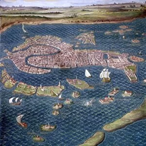
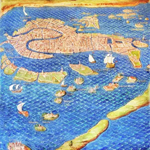
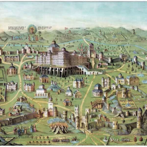
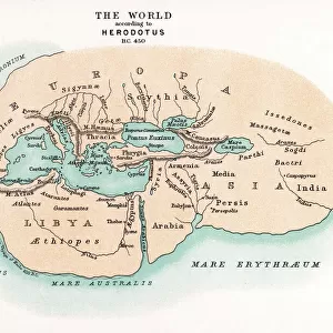
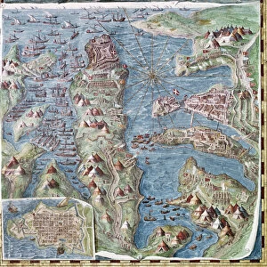
Premium Framed Print : MAP OF ITALY, c1585. By Ignazio Danti from Sistine Chapel Gallery of Maps


![]()
Framed Photos from Granger
MAP OF ITALY, c1585. By Ignazio Danti from Sistine Chapel Gallery of Maps
MAP OF ITALY, c1585.
By Ignazio Danti from Sistine Chapel Gallery of Maps
Granger holds millions of images spanning more than 25,000 years of world history, from before the Stone Age to the dawn of the Space Age
Media ID 12319654
17"x15" (43x38cm) Premium Frame
FSC real wood frame with double mounted 10x8 print. Double mounted with white conservation mountboard. Frame moulding comprises stained composite natural wood veneers (Finger Jointed Pine) 39mm wide by 21mm thick. Archival quality Fujifilm CA photo paper mounted onto 1mm card. Overall outside dimensions are 17x15 inches (431x381mm). Rear features Framing tape to cover staples, 50mm Hanger plate, cork bumpers. Glazed with durable thick 2mm Acrylic to provide a virtually unbreakable glass-like finish. Acrylic Glass is far safer, more flexible and much lighter than typical mineral glass. Moreover, its higher translucency makes it a perfect carrier for photo prints. Acrylic allows a little more light to penetrate the surface than conventional glass and absorbs UV rays so that the image and the picture quality doesn't suffer under direct sunlight even after many years. Easily cleaned with a damp cloth. Please note that, to prevent the paper falling through the mount window and to prevent cropping of the original artwork, the visible print may be slightly smaller to allow the paper to be securely attached to the mount without any white edging showing and to match the aspect ratio of the original artwork.
FSC Real Wood Frame and Double Mounted with White Conservation Mountboard - Professionally Made and Ready to Hang
Estimated Image Size (if not cropped) is 24.4cm x 17.4cm (9.6" x 6.9")
Estimated Product Size is 43.1cm x 38.1cm (17" x 15")
These are individually made so all sizes are approximate
Artwork printed orientated as per the preview above, with landscape (horizontal) orientation to match the source image.
FEATURES IN THESE COLLECTIONS
> Granger Art on Demand
> Maps
> Arts
> Art Movements
> Renaissance Art
> Arts
> Landscape paintings
> Waterfall and river artworks
> River artworks
> Historic
> Renaissance art
> Italian Renaissance art
> Maps and Charts
> Italy
> Maps and Charts
> Related Images
EDITORS COMMENTS
This print showcases the exquisite "Map of Italy, c1585" created by the talented Italian cartographer Ignazio Danti. This masterpiece is part of the renowned Sistine Chapel Gallery of Maps collection and offers a fascinating glimpse into Renaissance-era geography. Danti's intricate map depicts Italy with remarkable precision, highlighting its diverse regions, cities, and rivers. The attention to detail is truly awe-inspiring as each element is meticulously rendered, capturing the essence of this beautiful country during that period. As we delve into this historical artifact, we are transported back in time to witness Italy's rich cultural heritage unfold before our eyes. From north to south, every corner of this enchanting land comes alive through vibrant colors and delicate strokes. It allows us to trace the path of famous rivers like the Po or Tiber and discover their significance in shaping Italy's history. Beyond its aesthetic appeal, Danti's map serves as a testament to human curiosity and exploration during an era when knowledge was expanding rapidly. It reminds us that maps were not just tools for navigation but also works of art that celebrated both scientific accuracy and artistic expression. Whether you are an admirer of Italian culture or a lover of cartography, this stunning print will undoubtedly captivate your imagination while offering a window into Italy's past like never before.
MADE IN THE UK
Safe Shipping with 30 Day Money Back Guarantee
FREE PERSONALISATION*
We are proud to offer a range of customisation features including Personalised Captions, Color Filters and Picture Zoom Tools
SECURE PAYMENTS
We happily accept a wide range of payment options so you can pay for the things you need in the way that is most convenient for you
* Options may vary by product and licensing agreement. Zoomed Pictures can be adjusted in the Basket.