Premium Framed Print > Fine Art Storehouse > Map
Premium Framed Print : Africa map 1878


![]()
Framed Photos from Fine Art Storehouse
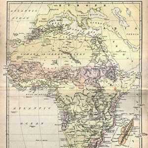
Africa map 1878
Encyclopedia Britannica 9th Edition Vol I New York, Samuel Hall 1878
Unleash your creativity and transform your space into a visual masterpiece!
THEPALMER
Media ID 13609273
© This content is subject to copyright
Central Africa East Africa Madagascar Sahara Desert
17"x15" (43x38cm) Premium Frame
FSC real wood frame with double mounted 10x8 print. Double mounted with white conservation mountboard. Frame moulding comprises stained composite natural wood veneers (Finger Jointed Pine) 39mm wide by 21mm thick. Archival quality Fujifilm CA photo paper mounted onto 1mm card. Overall outside dimensions are 17x15 inches (431x381mm). Rear features Framing tape to cover staples, 50mm Hanger plate, cork bumpers. Glazed with durable thick 2mm Acrylic to provide a virtually unbreakable glass-like finish. Acrylic Glass is far safer, more flexible and much lighter than typical mineral glass. Moreover, its higher translucency makes it a perfect carrier for photo prints. Acrylic allows a little more light to penetrate the surface than conventional glass and absorbs UV rays so that the image and the picture quality doesn't suffer under direct sunlight even after many years. Easily cleaned with a damp cloth. Please note that, to prevent the paper falling through the mount window and to prevent cropping of the original artwork, the visible print may be slightly smaller to allow the paper to be securely attached to the mount without any white edging showing and to match the aspect ratio of the original artwork.
FSC Real Wood Frame and Double Mounted with White Conservation Mountboard - Professionally Made and Ready to Hang
Estimated Image Size (if not cropped) is 19.1cm x 24.4cm (7.5" x 9.6")
Estimated Product Size is 38.1cm x 43.1cm (15" x 17")
These are individually made so all sizes are approximate
Artwork printed orientated as per the preview above, with portrait (vertical) orientation to match the source image.
FEATURES IN THESE COLLECTIONS
> Fine Art Storehouse
> Map
> Historical Maps
> Fine Art Storehouse
> Ultimate Earth Prints
> Amazing Deserts
EDITORS COMMENTS
This print showcases an exquisite piece of history - the Africa map from the Encyclopedia Britannica 9th Edition, published in 1878. Crafted by Samuel Hall in New York, this engraving and etching is a true testament to the artistry and precision of cartography during that era. The map takes us on a journey through time, revealing the intricate details of Africa's physical geography as understood over a century ago. From its vertical orientation to its central focus on regions like Central Africa, East Africa, and Madagascar, every element has been meticulously captured in this lithograph. One cannot help but marvel at how this antique engraved image has stood the test of time. The Sahara Desert dominates vast stretches of North Africa while rivers and mountain ranges crisscross various territories. It serves as a reminder not only of our ever-changing world but also of the enduring beauty found within these old maps. "The Palmer" known for their expertise in sourcing fine art prints, presents this remarkable piece with utmost care and attention to detail. As we gaze upon it, we are transported back to an era when exploration was paramount and cartographers were revered for their ability to bring distant lands closer through illustrations such as these. Whether you're an avid collector or simply appreciate historical artifacts, this print offers a glimpse into the past that will surely captivate any viewer.
MADE IN THE UK
Safe Shipping with 30 Day Money Back Guarantee
FREE PERSONALISATION*
We are proud to offer a range of customisation features including Personalised Captions, Color Filters and Picture Zoom Tools
SECURE PAYMENTS
We happily accept a wide range of payment options so you can pay for the things you need in the way that is most convenient for you
* Options may vary by product and licensing agreement. Zoomed Pictures can be adjusted in the Basket.