Premium Framed Print > Europe > United Kingdom > England > Kent > Green Street Green
Premium Framed Print : Canterbury Kent UK City Street Map


![]()
Framed Photos from Fine Art Storehouse
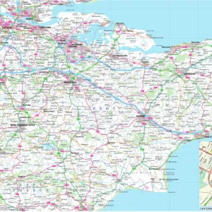
Canterbury Kent UK City Street Map
Vector Illustration of a City Street Map of Canterbury, Kent, UK. Included files are EPS (v10) and Hi-Res JPG.
Data courtesy from Ordnance Survey: VectorMap District
https:/ordnancesurvey.co.uk/business-and-government/products/vectormap-district.html
OS OpenData is free to use under the Open Government Licence (OGL).
Contains OS data eCrown copyright and database right 2017.
http:/nationalarchives.gov.uk/doc/open-government-licence/version/3/
Unleash your creativity and transform your space into a visual masterpiece!
Frank Ramspott
Media ID 15055235
© Frank Ramspott, all rights reserved
Aerial View Canterbury Computer Graphic Directly Above Gray Green Kent Road Map Street Map Text Digitally Generated Image River Stour
31"x27" (79x69cm) Premium Frame
FSC real wood frame with double mounted 24x20 print. Double mounted with white conservation mountboard. Frame moulding comprises stained composite natural wood veneers (Finger Jointed Pine) 39mm wide by 21mm thick. Archival quality Fujifilm CA photo paper mounted onto 1mm card. Overall outside dimensions are 31x27 inches (787x685mm). Rear features Framing tape to cover staples, 50mm Hanger plate, cork bumpers. Glazed with durable thick 2mm Acrylic to provide a virtually unbreakable glass-like finish. Acrylic Glass is far safer, more flexible and much lighter than typical mineral glass. Moreover, its higher translucency makes it a perfect carrier for photo prints. Acrylic allows a little more light to penetrate the surface than conventional glass and absorbs UV rays so that the image and the picture quality doesn't suffer under direct sunlight even after many years. Easily cleaned with a damp cloth. Please note that, to prevent the paper falling through the mount window and to prevent cropping of the original artwork, the visible print may be slightly smaller to allow the paper to be securely attached to the mount without any white edging showing and to match the aspect ratio of the original artwork.
FSC Real Wood Frame and Double Mounted with White Conservation Mountboard - Professionally Made and Ready to Hang
Estimated Image Size (if not cropped) is 59.9cm x 59.9cm (23.6" x 23.6")
Estimated Product Size is 68.5cm x 78.7cm (27" x 31")
These are individually made so all sizes are approximate
Artwork printed orientated as per the preview above, with landscape (horizontal) or portrait (vertical) orientation to match the source image.
FEATURES IN THESE COLLECTIONS
> Fine Art Storehouse
> Map
> Street Maps
> Aerial Photography
> Related Images
> Arts
> Contemporary art
> Digital artwork
> Street art
> Arts
> Landscape paintings
> Waterfall and river artworks
> River artworks
> Arts
> Portraits
> Pop art gallery
> Street art portraits
> Arts
> Street art graffiti
> Digital art
> Digital paintings
> Arts
> Street art graffiti
> Digital art
> Vector illustrations
> Europe
> United Kingdom
> England
> Kent
> Canterbury
> Europe
> United Kingdom
> England
> Kent
> Green Street Green
> Europe
> United Kingdom
> England
> Kent
> Kent Street
> Europe
> United Kingdom
> Maps
EDITORS COMMENTS
This stunning print captures the intricate details of Canterbury, a charming city in Kent, UK. The vector illustration showcases the city's street map with precision and clarity. Created by Frank Ramspott, this digitally generated image is a testament to his exceptional cartography skills. The print includes essential files such as EPS (v10) and Hi-Res JPG, ensuring high-quality reproduction. The data used for this artwork is courtesy of Ordnance Survey: VectorMap District, a reliable source known for its accuracy in mapping information. Highlighted in the image are notable features like the meandering River Stour that gracefully winds through Canterbury. The architectural beauty of buildings can be seen lining the streets, adding character to this historic town. With no people present in the picture, all focus remains on the captivating design and layout of Canterbury's urban landscape. The color scheme blends shades of gray, green, blue, and white harmoniously to create an aesthetically pleasing visual representation. This aerial view from directly above provides a unique perspective on Canterbury's physical geography. It serves as both an informative tool for navigation and an artistic piece that celebrates the artistry behind map-making.
MADE IN THE UK
Safe Shipping with 30 Day Money Back Guarantee
FREE PERSONALISATION*
We are proud to offer a range of customisation features including Personalised Captions, Color Filters and Picture Zoom Tools
SECURE PAYMENTS
We happily accept a wide range of payment options so you can pay for the things you need in the way that is most convenient for you
* Options may vary by product and licensing agreement. Zoomed Pictures can be adjusted in the Basket.