Premium Framed Print > Africa > Djibouti > Maps
Premium Framed Print : Djibouti country map


Resolution may be poor at this size (77 DPI)
![]()
Framed Photos from Fine Art Storehouse
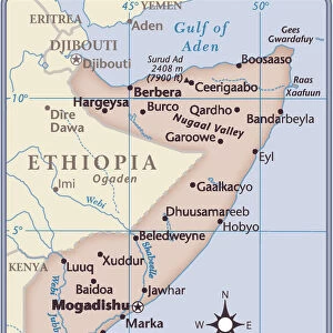
Djibouti country map
2011 edition
Unleash your creativity and transform your space into a visual masterpiece!
Media ID 14432071
17"x15" (43x38cm) Premium Frame
FSC real wood frame with double mounted 10x8 print. Double mounted with white conservation mountboard. Frame moulding comprises stained composite natural wood veneers (Finger Jointed Pine) 39mm wide by 21mm thick. Archival quality Fujifilm CA photo paper mounted onto 1mm card. Overall outside dimensions are 17x15 inches (431x381mm). Rear features Framing tape to cover staples, 50mm Hanger plate, cork bumpers. Glazed with durable thick 2mm Acrylic to provide a virtually unbreakable glass-like finish. Acrylic Glass is far safer, more flexible and much lighter than typical mineral glass. Moreover, its higher translucency makes it a perfect carrier for photo prints. Acrylic allows a little more light to penetrate the surface than conventional glass and absorbs UV rays so that the image and the picture quality doesn't suffer under direct sunlight even after many years. Easily cleaned with a damp cloth. Please note that, to prevent the paper falling through the mount window and to prevent cropping of the original artwork, the visible print may be slightly smaller to allow the paper to be securely attached to the mount without any white edging showing and to match the aspect ratio of the original artwork.
FSC Real Wood Frame and Double Mounted with White Conservation Mountboard - Professionally Made and Ready to Hang
Estimated Image Size (if not cropped) is 24.4cm x 20.6cm (9.6" x 8.1")
Estimated Product Size is 43.1cm x 38.1cm (17" x 15")
These are individually made so all sizes are approximate
Artwork printed orientated as per the preview above, with landscape (horizontal) orientation to match the source image.
FEATURES IN THESE COLLECTIONS
> Fine Art Storehouse
> Map
> Reference Maps
> Africa
> Djibouti
> Related Images
> Maps and Charts
> Related Images
EDITORS COMMENTS
This print showcases the Djibouti country map, specifically the 2011 edition. With intricate details and vibrant colors, it offers a visually stunning representation of this East African nation. The map highlights various geographical features, including mountains, rivers, and coastlines that define Djibouti's unique landscape. The composition of this artwork is truly remarkable; every contour and boundary has been meticulously captured to provide an accurate depiction of the country's topography. From afar, one can appreciate the overall shape of Djibouti as it sits strategically at the entrance to the Red Sea. As we delve deeper into this image, our eyes are drawn to specific landmarks such as Lake Assal - a mesmerizing saltwater lake known for its striking turquoise hue. We can also spot iconic cities like Djibouti City with its bustling port and urban sprawl. Beyond its aesthetic appeal, this print serves as more than just a decorative piece; it invites us to explore and learn about Djibouti's rich history and cultural heritage. Whether you have personal ties to this fascinating nation or simply possess an affinity for cartography, this artwork will undoubtedly spark conversations and ignite curiosity about one of Africa's hidden gems.
MADE IN THE UK
Safe Shipping with 30 Day Money Back Guarantee
FREE PERSONALISATION*
We are proud to offer a range of customisation features including Personalised Captions, Color Filters and Picture Zoom Tools
SECURE PAYMENTS
We happily accept a wide range of payment options so you can pay for the things you need in the way that is most convenient for you
* Options may vary by product and licensing agreement. Zoomed Pictures can be adjusted in the Basket.