Premium Framed Print > Arts > Artists > I > Italian School Italian School
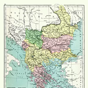
Premium Framed Print : Map of Central Europe 1895


![]()
Framed Photos from Fine Art Storehouse
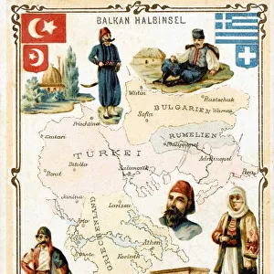
Map of Central Europe 1895
The Rand-McNally Grammar School Geography 1895 - Chicago & New York
Unleash your creativity and transform your space into a visual masterpiece!
THEPALMER
Media ID 14824625
© This content is subject to copyright
Austria Bulgaria Denmark Portugal Russia Serbia Sweden
17"x15" (43x38cm) Premium Frame
FSC real wood frame with double mounted 10x8 print. Double mounted with white conservation mountboard. Frame moulding comprises stained composite natural wood veneers (Finger Jointed Pine) 39mm wide by 21mm thick. Archival quality Fujifilm CA photo paper mounted onto 1mm card. Overall outside dimensions are 17x15 inches (431x381mm). Rear features Framing tape to cover staples, 50mm Hanger plate, cork bumpers. Glazed with durable thick 2mm Acrylic to provide a virtually unbreakable glass-like finish. Acrylic Glass is far safer, more flexible and much lighter than typical mineral glass. Moreover, its higher translucency makes it a perfect carrier for photo prints. Acrylic allows a little more light to penetrate the surface than conventional glass and absorbs UV rays so that the image and the picture quality doesn't suffer under direct sunlight even after many years. Easily cleaned with a damp cloth. Please note that, to prevent the paper falling through the mount window and to prevent cropping of the original artwork, the visible print may be slightly smaller to allow the paper to be securely attached to the mount without any white edging showing and to match the aspect ratio of the original artwork.
FSC Real Wood Frame and Double Mounted with White Conservation Mountboard - Professionally Made and Ready to Hang
Estimated Image Size (if not cropped) is 19.2cm x 24.4cm (7.6" x 9.6")
Estimated Product Size is 38.1cm x 43.1cm (15" x 17")
These are individually made so all sizes are approximate
Artwork printed orientated as per the preview above, with portrait (vertical) orientation to match the source image.
FEATURES IN THESE COLLECTIONS
> Fine Art Storehouse
> Map
> Denmark Maps
> Fine Art Storehouse
> Map
> Historical Maps
> Fine Art Storehouse
> Map
> Italian Maps
> Arts
> Artists
> I
> Italian School Italian School
> Arts
> Artists
> P
> Portuguese School
> Arts
> Artists
> S
> Spanish School
> Europe
> Austria
> Related Images
> Europe
> Bulgaria
> Related Images
EDITORS COMMENTS
In this print titled "Map of Central Europe 1895" artist THEPALMER takes us on a journey back in time to the late 19th century. The image showcases an intricately detailed map from "The Rand-McNally Grammar School Geography 1895" publication, originating from Chicago and New York. With its vintage charm, the map transports us to a bygone era when borders were different and nations had yet to experience significant geopolitical changes. We can trace our fingers across Portugal's western coast, Austria's majestic peaks, Bulgaria's rich cultural heritage, Denmark's picturesque landscapes, and many more iconic European destinations. This historical snapshot invites us to explore the diverse tapestry of Central Europe as it stood over a century ago. From France's romantic allure to Germany's industrial prowess, Italy's artistic legacy to Russia's vast expanse – each country holds its own unique story waiting to be discovered. As we gaze upon this remarkable piece of artistry, we are reminded of the power maps have in shaping our understanding of the world around us. They serve as windows into history while igniting our curiosity about distant lands and cultures. "The Map of Central Europe 1895" by THEPALMER is not just a mere depiction; it is an invitation for exploration and reflection on how our world has evolved throughout time. It serves as a reminder that beneath political boundaries lie shared histories that connect all humanity together.
MADE IN THE UK
Safe Shipping with 30 Day Money Back Guarantee
FREE PERSONALISATION*
We are proud to offer a range of customisation features including Personalised Captions, Color Filters and Picture Zoom Tools
SECURE PAYMENTS
We happily accept a wide range of payment options so you can pay for the things you need in the way that is most convenient for you
* Options may vary by product and licensing agreement. Zoomed Pictures can be adjusted in the Basket.