Premium Framed Print > Asia > Turkey > Istanbul
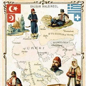
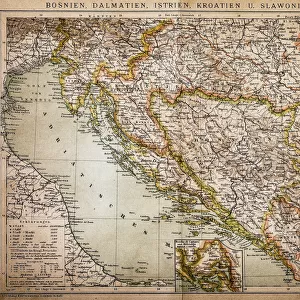
Premium Framed Print : Balkan Peninsula in 1878, lithograph


![]()
Framed Photos from Fine Art Storehouse
Balkan Peninsula in 1878, lithograph
Ancient map Balkan. The political classification of the Balkan Peninsula after the Treaty of Berlin in 1878. Lithograph, published in 1878
Unleash your creativity and transform your space into a visual masterpiece!
Media ID 13666833
© ZU_09
Adriatic Sea Aegean Sea Albania Austria Austria Hungary Balkans Black Sea Bosnia And Hercegovina Bulgaria Bulgarian Culture Contour Drawing Country Geographic Area Crete Greece Greek Culture Hungary Ionian Sea Istanbul Land Mediterranean Sea Montenegro Ottoman Empire Romania Serbia Serbian Culture Topographic Map Topography Transylvania Turkey Middle East Albanian Culture Obsolete Romanian Culture
17"x15" (43x38cm) Premium Frame
FSC real wood frame with double mounted 10x8 print. Double mounted with white conservation mountboard. Frame moulding comprises stained composite natural wood veneers (Finger Jointed Pine) 39mm wide by 21mm thick. Archival quality Fujifilm CA photo paper mounted onto 1mm card. Overall outside dimensions are 17x15 inches (431x381mm). Rear features Framing tape to cover staples, 50mm Hanger plate, cork bumpers. Glazed with durable thick 2mm Acrylic to provide a virtually unbreakable glass-like finish. Acrylic Glass is far safer, more flexible and much lighter than typical mineral glass. Moreover, its higher translucency makes it a perfect carrier for photo prints. Acrylic allows a little more light to penetrate the surface than conventional glass and absorbs UV rays so that the image and the picture quality doesn't suffer under direct sunlight even after many years. Easily cleaned with a damp cloth. Please note that, to prevent the paper falling through the mount window and to prevent cropping of the original artwork, the visible print may be slightly smaller to allow the paper to be securely attached to the mount without any white edging showing and to match the aspect ratio of the original artwork.
FSC Real Wood Frame and Double Mounted with White Conservation Mountboard - Professionally Made and Ready to Hang
Estimated Image Size (if not cropped) is 20.5cm x 24.4cm (8.1" x 9.6")
Estimated Product Size is 38.1cm x 43.1cm (15" x 17")
These are individually made so all sizes are approximate
Artwork printed orientated as per the preview above, with portrait (vertical) orientation to match the source image.
FEATURES IN THESE COLLECTIONS
> Fine Art Storehouse
> Map
> Historical Maps
> Asia
> Turkey
> Related Images
> Europe
> Albania
> Related Images
> Europe
> Austria
> Related Images
EDITORS COMMENTS
This lithograph takes us back in time to the year 1878, offering a glimpse into the political landscape of the Balkan Peninsula after the Treaty of Berlin. The intricate details and exquisite craftsmanship make this ancient map a true treasure for cartography enthusiasts and history buffs alike. As we explore this engraved image, we are transported to a bygone era when empires reigned supreme. The Ottoman Empire's influence is palpable, stretching across vast territories that encompassed present-day Turkey, parts of the Middle East, Hungary, Romania, Bulgaria, Albania, Montenegro, Serbia, Bosnia and Herzegovina. The Balkans emerge as a complex mosaic of cultures and histories intertwined with Greek influences from Crete all the way to Austria. The topographic map reveals stunning geographical features such as the Adriatic Sea caressing Croatia's coastline while Greece basks in its connection to both the Ionian Sea and Aegean Sea. Further east lies the majestic Black Sea alongside other significant bodies of water like the Mediterranean Sea. This lithograph serves as an invaluable window into a world long gone but not forgotten. It allows us to appreciate how borders have shifted over time while celebrating diverse cultural legacies etched upon these lands. Let it be a reminder that our past shapes our present and offers valuable lessons for generations yet to come.
MADE IN THE UK
Safe Shipping with 30 Day Money Back Guarantee
FREE PERSONALISATION*
We are proud to offer a range of customisation features including Personalised Captions, Color Filters and Picture Zoom Tools
SECURE PAYMENTS
We happily accept a wide range of payment options so you can pay for the things you need in the way that is most convenient for you
* Options may vary by product and licensing agreement. Zoomed Pictures can be adjusted in the Basket.