Premium Framed Print > Fine Art Storehouse > The Magical World of Illustration > Palmer Illustrated Collection
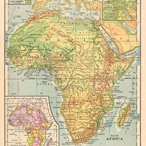
Premium Framed Print : Map of Africa 1869


![]()
Framed Photos from Fine Art Storehouse
Map of Africa 1869
Cornells Grammars-School Geography - S.S. Cornell - New York D. Appleton and Company 1869
Unleash your creativity and transform your space into a visual masterpiece!
THEPALMER
Media ID 13668853
© Roberto A Sanchez
Egypt Ethiopia Horn Of Africa Indian Ocean Middle East Obsolete
17"x15" (43x38cm) Premium Frame
FSC real wood frame with double mounted 10x8 print. Double mounted with white conservation mountboard. Frame moulding comprises stained composite natural wood veneers (Finger Jointed Pine) 39mm wide by 21mm thick. Archival quality Fujifilm CA photo paper mounted onto 1mm card. Overall outside dimensions are 17x15 inches (431x381mm). Rear features Framing tape to cover staples, 50mm Hanger plate, cork bumpers. Glazed with durable thick 2mm Acrylic to provide a virtually unbreakable glass-like finish. Acrylic Glass is far safer, more flexible and much lighter than typical mineral glass. Moreover, its higher translucency makes it a perfect carrier for photo prints. Acrylic allows a little more light to penetrate the surface than conventional glass and absorbs UV rays so that the image and the picture quality doesn't suffer under direct sunlight even after many years. Easily cleaned with a damp cloth. Please note that, to prevent the paper falling through the mount window and to prevent cropping of the original artwork, the visible print may be slightly smaller to allow the paper to be securely attached to the mount without any white edging showing and to match the aspect ratio of the original artwork.
FSC Real Wood Frame and Double Mounted with White Conservation Mountboard - Professionally Made and Ready to Hang
Estimated Image Size (if not cropped) is 20.3cm x 24.4cm (8" x 9.6")
Estimated Product Size is 38.1cm x 43.1cm (15" x 17")
These are individually made so all sizes are approximate
Artwork printed orientated as per the preview above, with portrait (vertical) orientation to match the source image.
FEATURES IN THESE COLLECTIONS
> Fine Art Storehouse
> The Magical World of Illustration
> Palmer Illustrated Collection
> Fine Art Storehouse
> Map
> Historical Maps
EDITORS COMMENTS
This print showcases a remarkable piece of cartographic history - the "Map of Africa 1869" from Cornells Grammars-School Geography. A product of its time, this engraved image transports us back to an era when physical geography was still being explored and understood. The intricate details and delicate engravings on this map offer a glimpse into the world as it was perceived in the late 19th century. Spanning across the vertical frame, we can trace our eyes over vast stretches of land and water, exploring the diverse regions that make up Africa. From Ethiopia to Egypt, every country is meticulously outlined with precision and care. The Indian Ocean glistens in vibrant blue hues, reminding us of its importance as a trade route connecting continents. The Middle East and Horn of Africa are also prominently featured, highlighting their significance in both historical context and contemporary geopolitics. This illustration serves as a visual testament to how borders have shifted over time while capturing the essence of African geography during this period. As we admire this antique masterpiece by THEPALMER from Fine Art Storehouse, we are reminded not only of its aesthetic value but also its educational significance. It invites us to reflect on how our understanding of maps has evolved throughout history while appreciating the artistry involved in creating such detailed engravings.
MADE IN THE UK
Safe Shipping with 30 Day Money Back Guarantee
FREE PERSONALISATION*
We are proud to offer a range of customisation features including Personalised Captions, Color Filters and Picture Zoom Tools
SECURE PAYMENTS
We happily accept a wide range of payment options so you can pay for the things you need in the way that is most convenient for you
* Options may vary by product and licensing agreement. Zoomed Pictures can be adjusted in the Basket.