Premium Framed Print > Fine Art Storehouse > Map
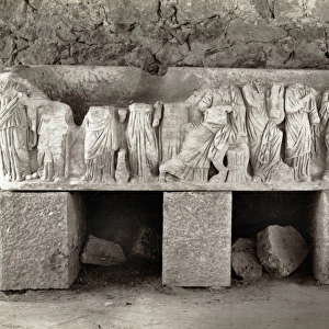
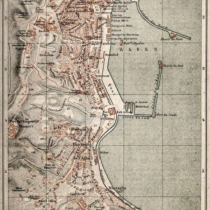
Premium Framed Print : Algeria surroundings map 1895


![]()
Framed Photos from Fine Art Storehouse
Algeria surroundings map 1895
Meyers Konversations-Lexikon. Ein Nachschlagewerk des allgemeinen Wissens, 5th edition 17 volumes Bibliographisches Institut - Leipzig 1895-1897
Unleash your creativity and transform your space into a visual masterpiece!
THEPALMER
Media ID 13611805
© This content is subject to copyright
Algeria Arabic Berber North Africa
23"x19" (58x48cm) Premium Frame
FSC real wood frame with double mounted 16x12 print. Double mounted with white conservation mountboard. Frame moulding comprises stained composite natural wood veneers (Finger Jointed Pine) 39mm wide by 21mm thick. Archival quality Fujifilm CA photo paper mounted onto 1mm card. Overall outside dimensions are 23x19 inches (584x482mm). Rear features Framing tape to cover staples, 50mm Hanger plate, cork bumpers. Glazed with durable thick 2mm Acrylic to provide a virtually unbreakable glass-like finish. Acrylic Glass is far safer, more flexible and much lighter than typical mineral glass. Moreover, its higher translucency makes it a perfect carrier for photo prints. Acrylic allows a little more light to penetrate the surface than conventional glass and absorbs UV rays so that the image and the picture quality doesn't suffer under direct sunlight even after many years. Easily cleaned with a damp cloth. Please note that, to prevent the paper falling through the mount window and to prevent cropping of the original artwork, the visible print may be slightly smaller to allow the paper to be securely attached to the mount without any white edging showing and to match the aspect ratio of the original artwork.
FSC Real Wood Frame and Double Mounted with White Conservation Mountboard - Professionally Made and Ready to Hang
Estimated Image Size (if not cropped) is 19.2cm x 39.6cm (7.6" x 15.6")
Estimated Product Size is 48.2cm x 58.4cm (19" x 23")
These are individually made so all sizes are approximate
Artwork printed orientated as per the preview above, with portrait (vertical) orientation to match the source image.
FEATURES IN THESE COLLECTIONS
> Fine Art Storehouse
> The Magical World of Illustration
> Palmer Illustrated Collection
> Fine Art Storehouse
> Map
> Historical Maps
> Fine Art Storehouse
> Map
> USA Maps
EDITORS COMMENTS
This print showcases a vintage map of Algeria's surroundings, dating back to 1895. Taken from the renowned Meyers Konversations-Lexikon, this piece is an exquisite representation of historical cartography. The intricate engraving and attention to detail transport us back in time, offering a glimpse into the rich cultural tapestry of North Africa. The map encompasses not only the capital city Algiers but also various regions inhabited by Arabic and Berber communities. Its vertical panoramic layout allows for a comprehensive view of Algeria's diverse landscapes and geographical features. From vast deserts to lush oases, this map captures the essence of this fascinating country. As we admire this illustration, we are reminded of the importance that maps hold in understanding our world's history and geography. They serve as windows into different eras, providing valuable insights into past civilizations and their connections with one another. "The Algerian Surroundings Map" by THEPALMER invites us on a visual journey through time while celebrating the artistry involved in creating such detailed engravings. Whether displayed in homes or offices, it serves as both an educational tool and a stunning piece of artwork that sparks curiosity about Algeria's past.
MADE IN THE UK
Safe Shipping with 30 Day Money Back Guarantee
FREE PERSONALISATION*
We are proud to offer a range of customisation features including Personalised Captions, Color Filters and Picture Zoom Tools
SECURE PAYMENTS
We happily accept a wide range of payment options so you can pay for the things you need in the way that is most convenient for you
* Options may vary by product and licensing agreement. Zoomed Pictures can be adjusted in the Basket.