Premium Framed Print > Animals > Mammals > Muridae > Desert Mouse
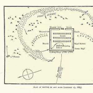
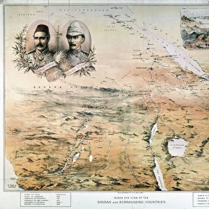
Premium Framed Print : Map of the area arounf the Battle of Abu Klea, 1885


![]()
Framed Photos from Fine Art Storehouse
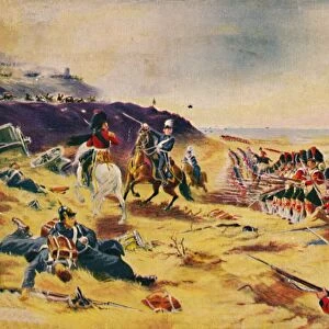
Map of the area arounf the Battle of Abu Klea, 1885
Vintage illustration of Map of the area arounf the Battle of Abu Klea, 1885. The Battle of Abu Klea, or the Battle of Abu Tulayh took place between the dates of 16 and 18 January 1885, at Abu Klea, Sudan, between the British Desert Column and Mahdist forces encamped near Abu Klea
Unleash your creativity and transform your space into a visual masterpiece!
duncan1890
Media ID 21157917
© of Duncan P Walker
Mahdist Mahdist War Sudan Campaign Abu Klea
17"x15" (43x38cm) Premium Frame
FSC real wood frame with double mounted 10x8 print. Double mounted with white conservation mountboard. Frame moulding comprises stained composite natural wood veneers (Finger Jointed Pine) 39mm wide by 21mm thick. Archival quality Fujifilm CA photo paper mounted onto 1mm card. Overall outside dimensions are 17x15 inches (431x381mm). Rear features Framing tape to cover staples, 50mm Hanger plate, cork bumpers. Glazed with durable thick 2mm Acrylic to provide a virtually unbreakable glass-like finish. Acrylic Glass is far safer, more flexible and much lighter than typical mineral glass. Moreover, its higher translucency makes it a perfect carrier for photo prints. Acrylic allows a little more light to penetrate the surface than conventional glass and absorbs UV rays so that the image and the picture quality doesn't suffer under direct sunlight even after many years. Easily cleaned with a damp cloth. Please note that, to prevent the paper falling through the mount window and to prevent cropping of the original artwork, the visible print may be slightly smaller to allow the paper to be securely attached to the mount without any white edging showing and to match the aspect ratio of the original artwork.
FSC Real Wood Frame and Double Mounted with White Conservation Mountboard - Professionally Made and Ready to Hang
Estimated Image Size (if not cropped) is 24.4cm x 19.5cm (9.6" x 7.7")
Estimated Product Size is 43.1cm x 38.1cm (17" x 15")
These are individually made so all sizes are approximate
Artwork printed orientated as per the preview above, with landscape (horizontal) orientation to match the source image.
FEATURES IN THESE COLLECTIONS
> Fine Art Storehouse
> History
> Battles & Wars
> Historcal Battle Maps and Plans
> Africa
> Sudan
> Related Images
> Animals
> Mammals
> Muridae
> Desert Mouse
> Historic
> Battles
> Related Images
> Maps and Charts
> Related Images
EDITORS COMMENTS
This vintage illustration captures the intricate details of a map depicting the area surrounding the historic Battle of Abu Klea in 1885. The battle, also known as the Battle of Abu Tulayh, unfolded between January 16th and 18th in Sudan. It pitted the British Desert Column against Mahdist forces who had established their camp near Abu Klea. The print showcases the strategic landscape where this significant clash took place during the larger context of the Mahdist War and Sudan Campaign. With meticulous precision, it highlights key geographical features that played a crucial role in shaping military tactics and outcomes. As we delve into this visual representation, we are transported back to an era when colonial powers vied for control over vast territories. The map serves as a testament to both historical events and cartographic artistry. Duncan1890's expertly preserved print allows us to appreciate not only its aesthetic value but also its educational significance. It offers viewers an opportunity to explore and understand how battles were fought on unfamiliar terrains, shedding light on strategies employed by both sides. Whether you are a history enthusiast or simply intrigued by maps from yesteryears, this remarkable piece is sure to captivate your imagination with its rich historical narrative woven into every contour line and symbol displayed on its surface.
MADE IN THE UK
Safe Shipping with 30 Day Money Back Guarantee
FREE PERSONALISATION*
We are proud to offer a range of customisation features including Personalised Captions, Color Filters and Picture Zoom Tools
SECURE PAYMENTS
We happily accept a wide range of payment options so you can pay for the things you need in the way that is most convenient for you
* Options may vary by product and licensing agreement. Zoomed Pictures can be adjusted in the Basket.