Premium Framed Print > Arts > Art Movements > Art Nouveau
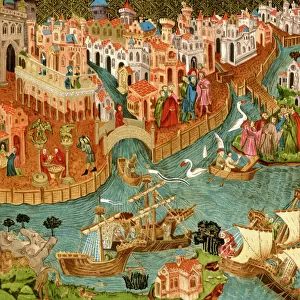
Premium Framed Print : Map of Palmanova, from Les Villes de Venetie, 1704


![]()
Framed Photos from Fine Art Finder
Map of Palmanova, from Les Villes de Venetie, 1704
REV345809 Map of Palmanova, from Les Villes de Venetie, 1704, published by Rutgert Alberts in the Hague (engraving) by French School, (18th century); Private Collection; (add.info.: plan; Atlas Nouveau Theatre d Italie ; revolutionary miltary fortress designed by Vincenzo Scamozzi (1548-1616); commemorates the Battle of Lepanto in 1571; bataille de Lepante; Friuli; Frioul; Venetia; Veneto; border with Slovenia; ); French, out of copyright
Media ID 22376448
© Bridgeman Images
Birds Eye Birds Eye View Cartographical Fortifications Fortified Gate Gates Mapping Moat Rampart Star Topographical Walls
31"x27" (79x69cm) Premium Frame
FSC real wood frame with double mounted 24x20 print. Double mounted with white conservation mountboard. Frame moulding comprises stained composite natural wood veneers (Finger Jointed Pine) 39mm wide by 21mm thick. Archival quality Fujifilm CA photo paper mounted onto 1mm card. Overall outside dimensions are 31x27 inches (787x685mm). Rear features Framing tape to cover staples, 50mm Hanger plate, cork bumpers. Glazed with durable thick 2mm Acrylic to provide a virtually unbreakable glass-like finish. Acrylic Glass is far safer, more flexible and much lighter than typical mineral glass. Moreover, its higher translucency makes it a perfect carrier for photo prints. Acrylic allows a little more light to penetrate the surface than conventional glass and absorbs UV rays so that the image and the picture quality doesn't suffer under direct sunlight even after many years. Easily cleaned with a damp cloth. Please note that, to prevent the paper falling through the mount window and to prevent cropping of the original artwork, the visible print may be slightly smaller to allow the paper to be securely attached to the mount without any white edging showing and to match the aspect ratio of the original artwork.
FSC Real Wood Frame and Double Mounted with White Conservation Mountboard - Professionally Made and Ready to Hang
Estimated Image Size (if not cropped) is 59.9cm x 54.6cm (23.6" x 21.5")
Estimated Product Size is 78.7cm x 68.5cm (31" x 27")
These are individually made so all sizes are approximate
Artwork printed orientated as per the preview above, with landscape (horizontal) orientation to match the source image.
FEATURES IN THESE COLLECTIONS
> Fine Art Finder
> Artists
> French School
> Fine Art Finder
> Maps (celestial & Terrestrial)
> Fine Art Finder
> War & Military Scenes Pre-20th Century
> Arts
> Art Movements
> Art Nouveau
> Arts
> Artists
> I
> Italian School Italian School
> Europe
> Italy
> Veneto
> Related Images
> Europe
> Italy
> Veneto
> Venice
> Europe
> Slovenia
> Related Images
> Historic
> Battles
> Related Images
EDITORS COMMENTS
This print showcases a historical treasure - the Map of Palmanova from Les Villes de Venetie, 1704. Published by Rutgert Alberts in the Hague, this engraving is a remarkable example of French School artistry from the 18th century. The map itself depicts Palmanova, an extraordinary military fortress designed by Vincenzo Scamozzi to commemorate the Battle of Lepanto in 1571. Situated on the border with Slovenia in Friuli-Venezia Giulia region, Italy, this nine-pointed star-shaped city stands as a testament to Italian ingenuity and architectural brilliance. With its intricate fortifications and imposing walls captured in meticulous detail, this birds-eye view offers a glimpse into the strategic planning that went into creating such an impregnable stronghold. The moat surrounding Palmanova adds another layer of defense while beautifully accentuating its geometric layout. As we explore this cartographical masterpiece further, we are reminded of Venice's influence on Italian history and culture. The Venetian mapping style shines through in every stroke of this engraving, transporting us back to an era when fortified towns like Palmanova played vital roles in safeguarding European territories. This print not only serves as a visual delight but also invites us to delve deeper into Europe's rich past and appreciate the artistic prowess behind these historical maps. A true gem for any admirer of cartography or lover of European heritage!
MADE IN THE UK
Safe Shipping with 30 Day Money Back Guarantee
FREE PERSONALISATION*
We are proud to offer a range of customisation features including Personalised Captions, Color Filters and Picture Zoom Tools
SECURE PAYMENTS
We happily accept a wide range of payment options so you can pay for the things you need in the way that is most convenient for you
* Options may vary by product and licensing agreement. Zoomed Pictures can be adjusted in the Basket.