Premium Framed Print > Arts > Artists > H > Franz Hogenberg
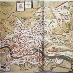
Premium Framed Print : Map of Barcelona and Ecija from Civitates Orbis Terrarum by Georg Braun


![]()
Framed Photos from Fine Art Finder
Map of Barcelona and Ecija from Civitates Orbis Terrarum by Georg Braun
AIS5366552 Map of Barcelona and Ecija from Civitates Orbis Terrarum by Georg Braun, 1541-1622 and Franz Hogenberg, 1540-1590 (engraving) by Hogenberg, Franz (1540-c.1590); Biblioteca Universidad, Salamanca, Spain; (add.info.: Cartography, Spain, 16th century. Map of Barcelona and Ecija. From Civitates Orbis Terrarum by Georg Braun (1541-1622) and Franz Hogenberg (1540-1590), Cologne. Engraving); eIberfoto; Netherlandish, out of copyright
Media ID 23712112
© Iberfoto / Bridgeman Images
16th Andalusia Barcelona Cartography And Historic Topography Catalonia Elevated View Horse Cart Human Representation Physical Geography Townscape Centuries Ecija
17"x15" (43x38cm) Premium Frame
FSC real wood frame with double mounted 10x8 print. Double mounted with white conservation mountboard. Frame moulding comprises stained composite natural wood veneers (Finger Jointed Pine) 39mm wide by 21mm thick. Archival quality Fujifilm CA photo paper mounted onto 1mm card. Overall outside dimensions are 17x15 inches (431x381mm). Rear features Framing tape to cover staples, 50mm Hanger plate, cork bumpers. Glazed with durable thick 2mm Acrylic to provide a virtually unbreakable glass-like finish. Acrylic Glass is far safer, more flexible and much lighter than typical mineral glass. Moreover, its higher translucency makes it a perfect carrier for photo prints. Acrylic allows a little more light to penetrate the surface than conventional glass and absorbs UV rays so that the image and the picture quality doesn't suffer under direct sunlight even after many years. Easily cleaned with a damp cloth. Please note that, to prevent the paper falling through the mount window and to prevent cropping of the original artwork, the visible print may be slightly smaller to allow the paper to be securely attached to the mount without any white edging showing and to match the aspect ratio of the original artwork.
FSC Real Wood Frame and Double Mounted with White Conservation Mountboard - Professionally Made and Ready to Hang
Estimated Image Size (if not cropped) is 24.4cm x 16.8cm (9.6" x 6.6")
Estimated Product Size is 43.1cm x 38.1cm (17" x 15")
These are individually made so all sizes are approximate
Artwork printed orientated as per the preview above, with landscape (horizontal) orientation to match the source image.
FEATURES IN THESE COLLECTIONS
> Fine Art Finder
> Artists
> Franz Hogenberg
> Fine Art Finder
> Artists
> Miguel Cabrera
> Arts
> Art Movements
> Landscapes
> Arts
> Artists
> H
> Franz Hogenberg
> Arts
> Contemporary art
> Landscapes
> Mountain landscapes
> Arts
> Landscape paintings
> Cityscape art
> Landscape paintings
> Arts
> Landscape paintings
> Cityscape art
> Arts
> Landscape paintings
> Landscape art
> Mountain landscapes
> Arts
> Landscape paintings
> Landscape art
> Arts
> Landscape paintings
> Waterfall and river artworks
> Landscape paintings
> Arts
> Landscape paintings
> Waterfall and river artworks
> River artworks
> Arts
> Landscape paintings
> Waterfall and river artworks
EDITORS COMMENTS
This print showcases a remarkable piece of cartography from the 16th century. The "Map of Barcelona and Ecija" is an engraving created by Georg Braun and Franz Hogenberg, two renowned artists of their time. This particular print can be found in the Biblioteca Universidad in Salamanca, Spain. The map itself offers a fascinating glimpse into the past, depicting the cities of Barcelona and Ecija with intricate detail. It provides a unique perspective on the physical geography of these regions, showcasing mountains, rivers, and even sailing boats along the coast. The vibrant colors used in this artwork bring life to the landscape, capturing both the beauty and historical significance of Catalonia and Andalusia. The absence of people allows us to focus solely on appreciating this masterpiece as a work of art. As we explore every inch of this map, we are transported back to a time when cartography was not only functional but also considered an art form. The precision with which every street and building is depicted demonstrates Braun's and Hogenberg's dedication to accuracy. This print serves as a reminder that history can be preserved through artistic expression. It invites us to delve into centuries-old manuscripts like Civitates Orbis Terrarum for insights into our world's rich past.
MADE IN THE UK
Safe Shipping with 30 Day Money Back Guarantee
FREE PERSONALISATION*
We are proud to offer a range of customisation features including Personalised Captions, Color Filters and Picture Zoom Tools
SECURE PAYMENTS
We happily accept a wide range of payment options so you can pay for the things you need in the way that is most convenient for you
* Options may vary by product and licensing agreement. Zoomed Pictures can be adjusted in the Basket.