Premium Framed Print > Europe > United Kingdom > England > London > Museums > National Army Museum
Premium Framed Print : Three printed coloured maps: Fairburns New Chart Exhibiting the Route of General


![]()
Framed Photos from Fine Art Finder
Three printed coloured maps: Fairburns New Chart Exhibiting the Route of General
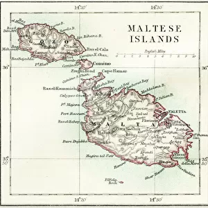
3062961 Three printed coloured maps: Fairburns New Chart Exhibiting the Route of General Bonaparte in the Mediterranean Sea, 1798 (engraving) by English School, (18th century); National Army Museum, London; (add.info.: With the Countries through which the French Army must pass, viz Egypt and the Red Sea; or the Gulf of Persia, & to Mangalore in the Territory of Tippoo Sahib, in the East Indies. To which is annexed A Particular Plan of the Island and Harbour of Malta.
Published 13 Aug 1798.
Associated with the Wars of the French Revolution, Egypt (1799-1801).); eNational Army Museum; English, out of copyright
Media ID 23115082
© National Army Museum / Bridgeman Images
Islands Malta Mediterranean Sea Napoleon Bonaparte General Bonaparte Gulf Of Persia
23"x19" (58x48cm) Premium Frame
FSC real wood frame with double mounted 16x12 print. Double mounted with white conservation mountboard. Frame moulding comprises stained composite natural wood veneers (Finger Jointed Pine) 39mm wide by 21mm thick. Archival quality Fujifilm CA photo paper mounted onto 1mm card. Overall outside dimensions are 23x19 inches (584x482mm). Rear features Framing tape to cover staples, 50mm Hanger plate, cork bumpers. Glazed with durable thick 2mm Acrylic to provide a virtually unbreakable glass-like finish. Acrylic Glass is far safer, more flexible and much lighter than typical mineral glass. Moreover, its higher translucency makes it a perfect carrier for photo prints. Acrylic allows a little more light to penetrate the surface than conventional glass and absorbs UV rays so that the image and the picture quality doesn't suffer under direct sunlight even after many years. Easily cleaned with a damp cloth. Please note that, to prevent the paper falling through the mount window and to prevent cropping of the original artwork, the visible print may be slightly smaller to allow the paper to be securely attached to the mount without any white edging showing and to match the aspect ratio of the original artwork.
FSC Real Wood Frame and Double Mounted with White Conservation Mountboard - Professionally Made and Ready to Hang
Estimated Image Size (if not cropped) is 39.6cm x 26cm (15.6" x 10.2")
Estimated Product Size is 58.4cm x 48.2cm (23" x 19")
These are individually made so all sizes are approximate
Artwork printed orientated as per the preview above, with landscape (horizontal) orientation to match the source image.
FEATURES IN THESE COLLECTIONS
> Fine Art Finder
> Artists
> English School
> Fine Art Finder
> Maps (celestial & Terrestrial)
> Africa
> Egypt
> Related Images
> Africa
> Related Images
> Europe
> Malta
> Related Images
> Europe
> United Kingdom
> England
> London
> Museums
> National Army Museum
EDITORS COMMENTS
This print showcases three beautifully colored maps titled "Fairburns New Chart Exhibiting the Route of General Bonaparte in the Mediterranean Sea, 1798". Created by an anonymous English School artist from the 18th century, these maps are housed at the National Army Museum in London. The intricate engravings depict various regions and countries that were significant during the time of Napoleon Bonaparte's military campaign. The first map highlights Egypt and the Red Sea, illustrating the path taken by the French Army. The second map extends to Mangalore in Tippoo Sahib's territory in East Indies, showcasing its strategic importance. Lastly, a detailed plan of Malta and its harbor is annexed to provide a comprehensive view. Published on August 13th, 1798, these maps hold historical significance as they are associated with the Wars of the French Revolution and specifically with Napoleon's expedition to Egypt between 1799-1801. They offer valuable insights into European expansionism during this era. Preserved by eNational Army Museum and made available through Bridgeman Images' collection on Fine Art Finder platform, this print allows viewers to delve into an important chapter of world history. With their vibrant colors and meticulous details, these maps serve as both educational tools for understanding past events and stunning pieces of art capturing cartographic excellence.
MADE IN THE UK
Safe Shipping with 30 Day Money Back Guarantee
FREE PERSONALISATION*
We are proud to offer a range of customisation features including Personalised Captions, Color Filters and Picture Zoom Tools
SECURE PAYMENTS
We happily accept a wide range of payment options so you can pay for the things you need in the way that is most convenient for you
* Options may vary by product and licensing agreement. Zoomed Pictures can be adjusted in the Basket.