Premium Framed Print > North America > United States of America > New York > New York > Maps
Premium Framed Print : A plan of New York Island, with part of Long Island, Staten Island & East New Jersey


![]()
Framed Photos from Fine Art Finder
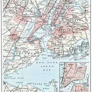
A plan of New York Island, with part of Long Island, Staten Island & East New Jersey
1079221 A plan of New York Island, with part of Long Island, Staten Island & East New Jersey, with a particular description of the engagement on the woody heights of Long Island between Flatbush and Brooklyn on the 27th of August 1776, 1776 (black ink and colour wash on paper) by Faden, William (1750-1836); 17x56 cm; Collection of the New-York Historical Society, USA; (add.info.: A plan of New York Island, with part of Long Island, Staten Island & East New Jersey, with a particular description of the engagement on the woody heights of Long Island between Flatbush and Brooklyn on the 27th of August 1776, 17 x 56 cm.); eNew York Historical Society; British, out of copyright
Media ID 22621838
© New York Historical Society / Bridgeman Images
Brooklyn Long Island Manhattan New Jersey Staten Island Surveys
17"x15" (43x38cm) Premium Frame
FSC real wood frame with double mounted 10x8 print. Double mounted with white conservation mountboard. Frame moulding comprises stained composite natural wood veneers (Finger Jointed Pine) 39mm wide by 21mm thick. Archival quality Fujifilm CA photo paper mounted onto 1mm card. Overall outside dimensions are 17x15 inches (431x381mm). Rear features Framing tape to cover staples, 50mm Hanger plate, cork bumpers. Glazed with durable thick 2mm Acrylic to provide a virtually unbreakable glass-like finish. Acrylic Glass is far safer, more flexible and much lighter than typical mineral glass. Moreover, its higher translucency makes it a perfect carrier for photo prints. Acrylic allows a little more light to penetrate the surface than conventional glass and absorbs UV rays so that the image and the picture quality doesn't suffer under direct sunlight even after many years. Easily cleaned with a damp cloth. Please note that, to prevent the paper falling through the mount window and to prevent cropping of the original artwork, the visible print may be slightly smaller to allow the paper to be securely attached to the mount without any white edging showing and to match the aspect ratio of the original artwork.
FSC Real Wood Frame and Double Mounted with White Conservation Mountboard - Professionally Made and Ready to Hang
Estimated Image Size (if not cropped) is 17.7cm x 24.4cm (7" x 9.6")
Estimated Product Size is 38.1cm x 43.1cm (15" x 17")
These are individually made so all sizes are approximate
Artwork printed orientated as per the preview above, with portrait (vertical) orientation to match the source image.
FEATURES IN THESE COLLECTIONS
> Fine Art Finder
> Artists
> American School
> Fine Art Finder
> Artists
> William Faden
> Arts
> Artists
> F
> William Faden
> Maps and Charts
> Early Maps
> Maps and Charts
> Related Images
> North America
> United States of America
> Maps
> North America
> United States of America
> New Jersey
> Jersey City
> North America
> United States of America
> New Jersey
> Related Images
> North America
> United States of America
> New York
> New York
> Brooklyn
> Related Images
> North America
> United States of America
> New York
> New York
> Manhattan
> Related Images
> North America
> United States of America
> New York
> New York
> Maps
EDITORS COMMENTS
This print showcases a historical treasure, "A plan of New York Island, with part of Long Island, Staten Island & East New Jersey". Created by William Faden in 1776, this black ink and color wash on paper artwork measures 17x56 cm and is currently housed in the esteemed collection of the New-York Historical Society in the USA. The intricate details of this map provide a fascinating glimpse into the past. It offers a particular description of the engagement that took place on August 27th, 1776, between Flatbush and Brooklyn on the woody heights of Long Island. This significant event during the American Revolution is depicted with precision and accuracy. As you explore this image further, you'll notice how it captures not only Manhattan but also parts of Long Island, Staten Island, and East New Jersey. The map serves as an invaluable resource for historians studying early American settlements and military strategies. With its rich history and detailed cartography, this print transports us back to a pivotal moment in time. It allows us to appreciate both the artistic skill involved in creating such maps during that era as well as their practical significance for understanding our nation's past. Whether you're an avid history enthusiast or simply intrigued by old maps, this remarkable piece from Fine Art Finder is sure to captivate your imagination.
MADE IN THE UK
Safe Shipping with 30 Day Money Back Guarantee
FREE PERSONALISATION*
We are proud to offer a range of customisation features including Personalised Captions, Color Filters and Picture Zoom Tools
SECURE PAYMENTS
We happily accept a wide range of payment options so you can pay for the things you need in the way that is most convenient for you
* Options may vary by product and licensing agreement. Zoomed Pictures can be adjusted in the Basket.