Premium Framed Print > Africa > Sudan > Maps
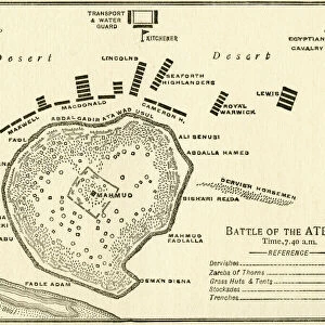
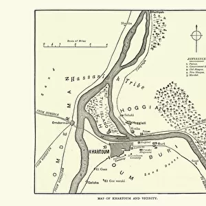
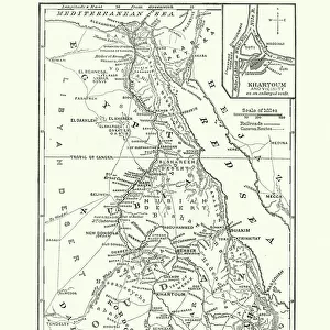
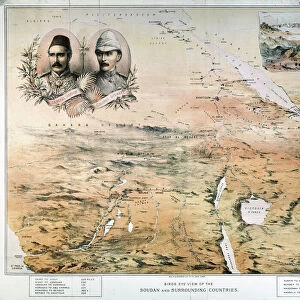
Premium Framed Print : Map Of The Battle Of Omdurman, Khartoum, Sudan, 1898, Showing The 1st Attack At 6. 45 A. m. And The Khalifas Attack At 9. 40 A. m. From Field Marshal Lord Kitchener, His Life And Work For The Empire, Published 1916


![]()
Framed Photos from Design Pics
Map Of The Battle Of Omdurman, Khartoum, Sudan, 1898, Showing The 1st Attack At 6. 45 A. m. And The Khalifas Attack At 9. 40 A. m. From Field Marshal Lord Kitchener, His Life And Work For The Empire, Published 1916
Map Of The Battle Of Omdurman, Khartoum, Sudan, 1898, Showing The 1st Attack At 6.45 A.m. And The Khalifas Attack At 9.40 A.m. From Field Marshal Lord Kitchener, His Life And Work For The Empire, Published 1916
Design Pics offers Distinctively Different Imagery representing over 1,500 contributors
Media ID 18199747
© Ken Welsh / Design Pics
1898 Anglo Attack Battle Revolt Showing Sudan Sudanese Anglo Sudan War Khalifas Khartoum Mahdist Mahdist Revolt Mahdist War Omdurman
23"x19" (58x48cm) Premium Frame
FSC real wood frame with double mounted 16x12 print. Double mounted with white conservation mountboard. Frame moulding comprises stained composite natural wood veneers (Finger Jointed Pine) 39mm wide by 21mm thick. Archival quality Fujifilm CA photo paper mounted onto 1mm card. Overall outside dimensions are 23x19 inches (584x482mm). Rear features Framing tape to cover staples, 50mm Hanger plate, cork bumpers. Glazed with durable thick 2mm Acrylic to provide a virtually unbreakable glass-like finish. Acrylic Glass is far safer, more flexible and much lighter than typical mineral glass. Moreover, its higher translucency makes it a perfect carrier for photo prints. Acrylic allows a little more light to penetrate the surface than conventional glass and absorbs UV rays so that the image and the picture quality doesn't suffer under direct sunlight even after many years. Easily cleaned with a damp cloth. Please note that, to prevent the paper falling through the mount window and to prevent cropping of the original artwork, the visible print may be slightly smaller to allow the paper to be securely attached to the mount without any white edging showing and to match the aspect ratio of the original artwork.
FSC Real Wood Frame and Double Mounted with White Conservation Mountboard - Professionally Made and Ready to Hang
Estimated Image Size (if not cropped) is 25.7cm x 39.6cm (10.1" x 15.6")
Estimated Product Size is 48.2cm x 58.4cm (19" x 23")
These are individually made so all sizes are approximate
Artwork printed orientated as per the preview above, with portrait (vertical) orientation to match the source image.
FEATURES IN THESE COLLECTIONS
> Africa
> Sudan
> Related Images
> Maps and Charts
> Related Images
EDITORS COMMENTS
This print showcases a historically significant moment in the Battle of Omdurman, Khartoum, Sudan in 1898. The detailed map depicts two crucial attacks during the conflict: the first attack at 6.45 a. m. , followed by the Khalifas' attack at 9.40 a. m. This remarkable piece is sourced from "Field Marshal Lord Kitchener, His Life And Work For The Empire" published in 1916. The Battle of Omdurman was part of the larger Mahdist War and marked a turning point in Anglo-Sudanese relations. It was fought between British-Egyptian forces led by General Horatio Herbert Kitchener and Sudanese Mahdist rebels under Khalifa Abdullahi ibn Muhammad's leadership. As you study this map, you can imagine the intensity and strategic planning that went into these attacks as both sides vied for control over Khartoum. The intricate details provide insight into how military tactics were employed during this era. Ken Welsh's expertly captured print allows us to delve into history and understand the complexities of this pivotal battle better. It serves as a reminder of Lord Kitchener's contributions to his empire and sheds light on an important chapter in Sudanese history
MADE IN THE UK
Safe Shipping with 30 Day Money Back Guarantee
FREE PERSONALISATION*
We are proud to offer a range of customisation features including Personalised Captions, Color Filters and Picture Zoom Tools
SECURE PAYMENTS
We happily accept a wide range of payment options so you can pay for the things you need in the way that is most convenient for you
* Options may vary by product and licensing agreement. Zoomed Pictures can be adjusted in the Basket.