Poster Print > Maps and Charts > Related Images
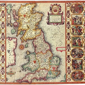
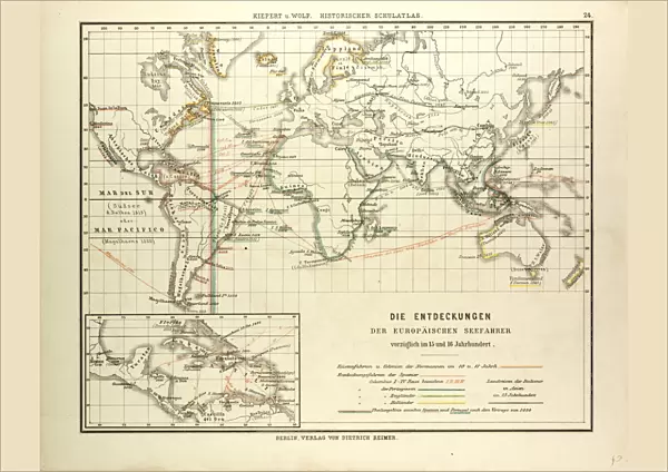
Poster Print : MAP OF THE DISCOVERIES OF EUROPEAN SEAFARERS IN THE 15TH AND 16TH CENTURIES


![]()
Poster Prints from Universal Images Group (UIG)
MAP OF THE DISCOVERIES OF EUROPEAN SEAFARERS IN THE 15TH AND 16TH CENTURIES
Universal Images Group (UIG) manages distribution for many leading specialist agencies worldwide
Media ID 20165135
© Universal Images Group
15th Century 16th Century 1872 Engraving Discoveries Heir Nineteenth Century Map Wandering
A2 (59.4 x 42cm) Poster Print
Step back in time and explore the fascinating world of European maritime exploration with our stunning vintage map print from the Universal History Archive. This intricately detailed map, titled "MAP OF THE DISCOVERIES OF EUROPEAN SEAFARERS IN THE 15TH AND 16TH CENTURIES" (000035 from Universal Images Group), beautifully illustrates the major discoveries and routes made by intrepid European seafarers during the Age of Discovery. A must-have for history enthusiasts, educators, or anyone with a passion for the past, this vintage map print makes a captivating addition to any wall in your home or office.
A2 Poster (59.4 x 42cm, 23.4" x 16.5" inches) printed on 170gsm Satin Poster Paper. Securely packaged, rolled and inserted into a strong mailing tube and shipped tracked. Poster Prints are of comparable archival quality to our Photographic prints, they are simply printed on thinner Poster Paper. Whilst we only use Photographic Prints in our frames, you can frame Poster Prints if they are carefully supported to prevent sagging over time.
Poster prints are budget friendly enlarged prints in standard poster paper sizes (A0, A1, A2, A3 etc). Whilst poster paper is sometimes thinner and less durable than our other paper types, they are still ok for framing and should last many years. Our Archival Quality Photo Prints and Fine Art Paper Prints are printed on higher quality paper and the choice of which largely depends on your budget.
Estimated Image Size (if not cropped) is 52.3cm x 42cm (20.6" x 16.5")
Estimated Product Size is 59.4cm x 42cm (23.4" x 16.5")
These are individually made so all sizes are approximate
Artwork printed orientated as per the preview above, with landscape (horizontal) orientation to match the source image.
FEATURES IN THESE COLLECTIONS
> Maps and Charts
> Related Images
> Universal Images Group (UIG)
> History
> Historical Maps
EDITORS COMMENTS
This 19th-century engraving, titled "Map of the Discoveries of European Seafarers in the 15th and 16th Centuries" takes us on a nostalgic journey through history. Created in 1872, it beautifully captures the spirit of exploration that defined this era. The intricately detailed map showcases the remarkable voyages undertaken by European seafarers during the 15th and 16th centuries. It serves as a testament to their courage, curiosity, and determination to chart unknown territories across vast oceans. Rendered in a retro Victorian style, this vintage print exudes an air of historic charm. The illustrative technique employed here is truly remarkable; every line and contour meticulously engraved to bring forth an heirloom-quality piece of art. As we gaze upon this enchanting image, we are transported back in time – imagining ourselves aboard those ancient vessels sailing towards uncharted horizons. We can almost feel the excitement pulsating through these brave sailors as they set foot on new lands and encountered diverse cultures. This engraving from Universal History Archive not only celebrates human ingenuity but also pays homage to our collective thirst for knowledge and adventure. It reminds us that throughout history, mankind has always been driven by an innate desire to explore beyond what is known - pushing boundaries with unwavering curiosity. So let us cherish this magnificent piece of historical artwork – a window into our past filled with tales of discovery and wonderment.
MADE IN THE UK
Safe Shipping with 30 Day Money Back Guarantee
FREE PERSONALISATION*
We are proud to offer a range of customisation features including Personalised Captions, Color Filters and Picture Zoom Tools
SECURE PAYMENTS
We happily accept a wide range of payment options so you can pay for the things you need in the way that is most convenient for you
* Options may vary by product and licensing agreement. Zoomed Pictures can be adjusted in the Basket.