Poster Print > Maps and Charts > Related Images
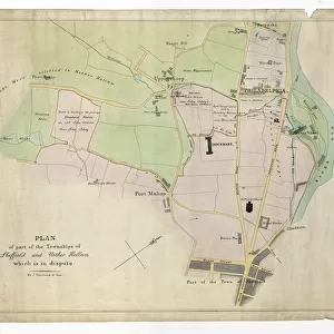
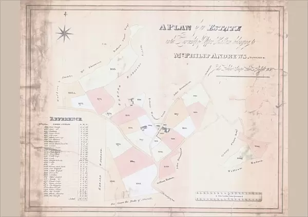
Poster Print : A Plan of an Estate in the Township of Upper Hallam belonging to Mr Philip Andrews, 1830


![]()
Poster Prints from Sheffield City Archives
A Plan of an Estate in the Township of Upper Hallam belonging to Mr Philip Andrews, 1830
Surveyor: John Leather.Original at Sheffield Local Studies Library:s (9) 1 L
Sheffield City Archives and Local Studies Library has an unrivalled collection of images of Sheffield, England
Media ID 14089489
© Sheffield City Council
A2 (59.4 x 42cm) Poster Print
"Step back in time with our exquisite Media Storehouse Poster Print of "A Plan of an Estate in the Township of Upper Hallam," originally surveyed by John Leather in 1830 for Mr. Philip Andrews. This fascinating historical print, which is housed at the Sheffield Local Studies Library, offers a unique glimpse into the past. The intricate detail of the estate plan reveals the layout of the land, its boundaries, and the names of adjacent properties, providing a valuable insight into the history of Upper Hallam over 180 years ago. Adorn your walls with this beautiful piece of local heritage and add character to any room in your home or office."
A2 Poster (59.4 x 42cm, 23.4" x 16.5" inches) printed on 170gsm Satin Poster Paper. Securely packaged, rolled and inserted into a strong mailing tube and shipped tracked. Poster Prints are of comparable archival quality to our Photographic prints, they are simply printed on thinner Poster Paper. Whilst we only use Photographic Prints in our frames, you can frame Poster Prints if they are carefully supported to prevent sagging over time.
Poster prints are budget friendly enlarged prints in standard poster paper sizes (A0, A1, A2, A3 etc). Whilst poster paper is sometimes thinner and less durable than our other paper types, they are still ok for framing and should last many years. Our Archival Quality Photo Prints and Fine Art Paper Prints are printed on higher quality paper and the choice of which largely depends on your budget.
Estimated Image Size (if not cropped) is 51.7cm x 42cm (20.4" x 16.5")
Estimated Product Size is 59.4cm x 42cm (23.4" x 16.5")
These are individually made so all sizes are approximate
Artwork printed orientated as per the preview above, with landscape (horizontal) orientation to match the source image.
FEATURES IN THESE COLLECTIONS
> Maps and Charts
> Related Images
> Sheffield City Archives
> Maps and Plans
> Maps of Sheffield
EDITORS COMMENTS
This print showcases a historical treasure, "A Plan of an Estate in the Township of Upper Hallam belonging to Mr Philip Andrews" dating back to 1830. The meticulous work of surveyor John Leather is evident in this remarkable piece, which can be found at the Sheffield Local Studies Library within the Sheffield City Archives. The image transports us back to a bygone era, offering a glimpse into the past and shedding light on the development and layout of Upper Hallam during that time. As we examine this plan closely, we are immersed in its intricate details: carefully drawn boundaries, precise measurements, and meticulously labeled landmarks. Through this snapshot from history, we gain insight into Mr Philip Andrews' estate - his property's size and shape intricately captured on paper. This visual representation allows us to appreciate how land was divided and utilized during that period. Preserved for generations to come at Sheffield Local Studies Library, this map serves as a testament to our city's rich heritage. It reminds us of the importance of preserving historical documents like these so that future generations can learn about their local roots. As we admire this print today, let it serve as a reminder not only of our collective history but also as an inspiration for further exploration into Sheffield's fascinating past.
MADE IN THE UK
Safe Shipping with 30 Day Money Back Guarantee
FREE PERSONALISATION*
We are proud to offer a range of customisation features including Personalised Captions, Color Filters and Picture Zoom Tools
SECURE PAYMENTS
We happily accept a wide range of payment options so you can pay for the things you need in the way that is most convenient for you
* Options may vary by product and licensing agreement. Zoomed Pictures can be adjusted in the Basket.