Poster Print > Arts > Artists > O > Oceanic Oceanic
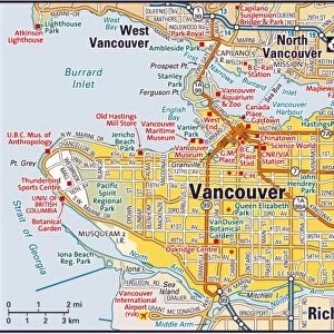
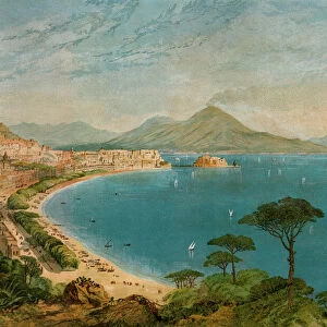
Poster Print : Vancouver Island map, 1870s


![]()
Poster Prints from North Wind
Vancouver Island map, 1870s
Map of Vancouver Island, British Columbia, Canada, 1870s.
Lithograph reproduction of a 19th-century illustration
North Wind Picture Archives brings history to life with stock images and hand-colored illustrations
Media ID 5879572
© North Wind Picture Archives
1870s 1880s British Columbia Canada Canadian Island Pacific Pacific Coast Pacific Northwest Pacific Ocean Strait Juan De Fuca Strait Puget Sound Vancouver Vancouver Island
A2 (59.4 x 42cm) Poster Print
Discover the rich history of Vancouver Island with our exquisite collection of vintage poster prints from Media Storehouse. This captivating reproduction showcases an 1870s map of Vancouver Island, taken from the North Wind Picture Archives. Transport yourself back in time with this intricately detailed lithograph, showcasing the unexplored territories and early settlements of British Columbia, Canada. Ideal for history enthusiasts, educators, or anyone who appreciates the beauty of historical cartography, this poster print makes a thoughtful addition to any room. Bring a piece of the past into your home or office today.
A2 Poster (59.4 x 42cm, 23.4" x 16.5" inches) printed on 170gsm Satin Poster Paper. Securely packaged, rolled and inserted into a strong mailing tube and shipped tracked. Poster Prints are of comparable archival quality to our Photographic prints, they are simply printed on thinner Poster Paper. Whilst we only use Photographic Prints in our frames, you can frame Poster Prints if they are carefully supported to prevent sagging over time.
Poster prints are budget friendly enlarged prints in standard poster paper sizes (A0, A1, A2, A3 etc). Whilst poster paper is sometimes thinner and less durable than our other paper types, they are still ok for framing and should last many years. Our Archival Quality Photo Prints and Fine Art Paper Prints are printed on higher quality paper and the choice of which largely depends on your budget.
Estimated Image Size (if not cropped) is 55.2cm x 42cm (21.7" x 16.5")
Estimated Product Size is 59.4cm x 42cm (23.4" x 16.5")
These are individually made so all sizes are approximate
Artwork printed orientated as per the preview above, with landscape (horizontal) orientation to match the source image.
FEATURES IN THESE COLLECTIONS
> North Wind Picture Archives
> Canadian history
> North Wind Picture Archives
> Maps
> Arts
> Artists
> O
> Oceanic Oceanic
> Maps and Charts
> Related Images
> North America
> Canada
> Maps
> North America
> Canada
> Related Images
> North America
> Canada
> Vancouver
> North America
> Related Images
> Popular Themes
> North Island
EDITORS COMMENTS
This lithograph reproduction takes us back to the 1870s, offering a glimpse into the rich history and heritage of Vancouver Island, British Columbia. The vintage map showcases the island's intricate details with remarkable precision and artistry. As we explore this piece of traditional artwork, our eyes are immediately drawn to the majestic Pacific Ocean that surrounds Vancouver Island. The map highlights its strategic location along the Pacific Coast, nestled between Juan de Fuca Strait and Puget Sound. The illustration beautifully captures the essence of this Canadian gem, depicting its lush landscapes, charming towns, and bustling ports. It serves as a testament to the island's significance during this era when it was rapidly developing as an important hub in North America. Every stroke on this historic map tells a story – from early settlements to indigenous territories – providing us with invaluable insights into how Vancouver Island evolved over time. This print is not just a visual delight; it is also an educational tool that allows us to delve deeper into Canada's past. Whether you are an art enthusiast or a history buff, this exquisite 19th-century lithograph offers a window into bygone days. It invites you on a journey through time while celebrating the natural beauty and cultural heritage of Vancouver Island – truly capturing its spirit for generations to come.
MADE IN THE UK
Safe Shipping with 30 Day Money Back Guarantee
FREE PERSONALISATION*
We are proud to offer a range of customisation features including Personalised Captions, Color Filters and Picture Zoom Tools
SECURE PAYMENTS
We happily accept a wide range of payment options so you can pay for the things you need in the way that is most convenient for you
* Options may vary by product and licensing agreement. Zoomed Pictures can be adjusted in the Basket.