Poster Print > Animals > Fishes > G > Grouper
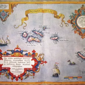
Poster Print : MAPS / AZORES


![]()
Poster Prints from Mary Evans Picture Library
MAPS / AZORES
maps of the individual islands of the Azores group Date: mid 19th century
Mary Evans Picture Library makes available wonderful images created for people to enjoy over the centuries
Media ID 20147619
© Bubblepunk
Atlantic Azores Individual Maps
A2 (59.4 x 42cm) Poster Print
Discover the enchanting beauty of the Azores with our exquisite collection of antique map prints from Media Storehouse, in partnership with Mary Evans Prints Online. These intricately detailed maps, dating back to the mid-19th century, offer a captivating glimpse into the history and geography of the individual islands that make up this unique archipelago in the Atlantic Ocean. Each print showcases the islands' rich topography, from volcanic landscapes to idyllic harbors, providing a stunning addition to any home or office space. Transport yourself to the heart of the Azores with these authentic and timeless pieces.
A2 Poster (59.4 x 42cm, 23.4" x 16.5" inches) printed on 170gsm Satin Poster Paper. Securely packaged, rolled and inserted into a strong mailing tube and shipped tracked. Poster Prints are of comparable archival quality to our Photographic prints, they are simply printed on thinner Poster Paper. Whilst we only use Photographic Prints in our frames, you can frame Poster Prints if they are carefully supported to prevent sagging over time.
Poster prints are budget friendly enlarged prints in standard poster paper sizes (A0, A1, A2, A3 etc). Whilst poster paper is sometimes thinner and less durable than our other paper types, they are still ok for framing and should last many years. Our Archival Quality Photo Prints and Fine Art Paper Prints are printed on higher quality paper and the choice of which largely depends on your budget.
Estimated Image Size (if not cropped) is 59.4cm x 35.8cm (23.4" x 14.1")
Estimated Product Size is 59.4cm x 42cm (23.4" x 16.5")
These are individually made so all sizes are approximate
Artwork printed orientated as per the preview above, with landscape (horizontal) orientation to match the source image.
FEATURES IN THESE COLLECTIONS
> Mary Evans Prints Online
> New Images July 2020
> Animals
> Fishes
> G
> Grouper
> Maps and Charts
> Related Images
EDITORS COMMENTS
This mid-19th century print showcases a collection of intricately detailed maps representing the individual islands of the enchanting Azores archipelago, located in the heart of the North Atlantic Ocean. The Azores, a Portuguese territory, consist of nine volcanic islands and are renowned for their breathtaking landscapes, unique culture, and natural beauty. Each map meticulously depicts the islands' topography, including their rugged coastlines, lush green valleys, and the distinctive conical shapes of their volcanic peaks. The islands' names are clearly labeled in elegant script, making it easy for the viewer to identify each one. The Azores have long been a source of fascination for explorers and travelers, and these maps offer a glimpse into the knowledge and understanding of the region during the mid-19th century. The intricate lines and precise cartography reveal the meticulous work of the mapmakers, who painstakingly documented the islands' features. The Azores' location in the mid-Atlantic Ocean, midway between Europe and North America, has made them a strategic point of interest throughout history. These maps provide valuable insight into the geography of the region during a time when long-distance travel was a significant challenge. This print is a beautiful reminder of the rich history and natural wonders of the Azores, and it invites the viewer to explore the islands' unique character and charm. Whether used as decorative pieces or as tools for research, these maps offer a fascinating glimpse into the past and serve as a testament to the enduring allure of the Azores.
MADE IN THE UK
Safe Shipping with 30 Day Money Back Guarantee
FREE PERSONALISATION*
We are proud to offer a range of customisation features including Personalised Captions, Color Filters and Picture Zoom Tools
SECURE PAYMENTS
We happily accept a wide range of payment options so you can pay for the things you need in the way that is most convenient for you
* Options may vary by product and licensing agreement. Zoomed Pictures can be adjusted in the Basket.