Poster Print > Europe > Netherlands > Maps
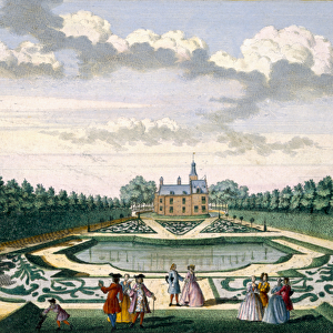
Poster Print : MAP / NETHERLANDS 1788


![]()
Poster Prints from Mary Evans Picture Library
MAP / NETHERLANDS 1788
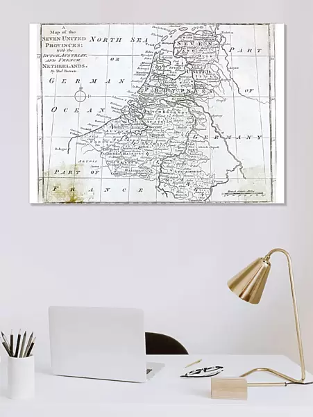
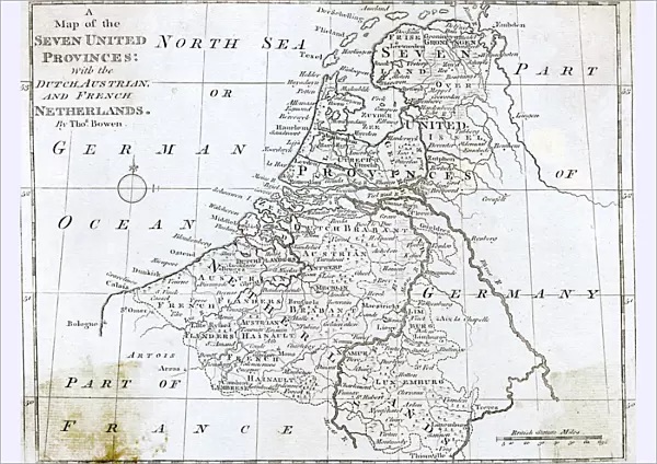
Map of the Seven United Provinces, with the Dutch, Austrian and French Netherlands Date: 1788
Mary Evans Picture Library makes available wonderful images created for people to enjoy over the centuries
Media ID 20153869
© Bubblepunk
1788 Austrian Maps Netherlands Provinces
A2 (59.4 x 42cm) Poster Print
Discover history in vibrant detail with our Media Storehouse Poster Prints featuring the intricately detailed map of "MAP / NETHERLANDS 1788." This historic map, sourced from Mary Evans Prints Online, showcases the Seven United Provinces of the Netherlands during the year 1788. The map illustrates the Dutch, Austrian, and French territories with precise cartography and rich coloring, transporting you back in time. Perfect for history enthusiasts, educators, or anyone interested in the intricacies of geography and historical cartography, our high-quality poster prints make for stunning wall art that adds depth and character to any room.
A2 Poster (59.4 x 42cm, 23.4" x 16.5" inches) printed on 170gsm Satin Poster Paper. Securely packaged, rolled and inserted into a strong mailing tube and shipped tracked. Poster Prints are of comparable archival quality to our Photographic prints, they are simply printed on thinner Poster Paper. Whilst we only use Photographic Prints in our frames, you can frame Poster Prints if they are carefully supported to prevent sagging over time.
Poster prints are budget friendly enlarged prints in standard poster paper sizes (A0, A1, A2, A3 etc). Whilst poster paper is sometimes thinner and less durable than our other paper types, they are still ok for framing and should last many years. Our Archival Quality Photo Prints and Fine Art Paper Prints are printed on higher quality paper and the choice of which largely depends on your budget.
Estimated Image Size (if not cropped) is 55.7cm x 42cm (21.9" x 16.5")
Estimated Product Size is 59.4cm x 42cm (23.4" x 16.5")
These are individually made so all sizes are approximate
Artwork printed orientated as per the preview above, with landscape (horizontal) orientation to match the source image.
FEATURES IN THESE COLLECTIONS
> Mary Evans Prints Online
> New Images July 2020
> Europe
> Austria
> Related Images
> Europe
> Netherlands
> Maps
> Europe
> Netherlands
> Posters
> Europe
> Netherlands
> Related Images
> Europe
> Related Images
EDITORS COMMENTS
This stunning map print, titled "Map of the Seven United Provinces, with the Dutch, Austrian and French Netherlands," dates back to 1788. The map provides a detailed and intricate depiction of Europe during a pivotal moment in its history. The Seven United Provinces, also known as the Dutch Republic, are prominently featured in the map, occupying the central and northern regions of the modern-day Netherlands. The map also highlights the Austrian and French territories, reflecting the complex political landscape of the time. The Austrian Netherlands, ruled by the Habsburg Monarchy, are shown to the south, while the French Netherlands, or the Austrian Netherlands under French control, are depicted to the southeast. The map also includes the Prussian territories, the Rhine River, and the North Sea. The intricate detail of this map is truly remarkable, with cities, towns, and villages marked with precision. The map also includes topographical features, such as mountains, forests, and bodies of water. The cartouche, or decorative border, features an elaborate design of a Dutch windmill, symbolizing the importance of the windmill industry in the Netherlands during this period. This map provides a fascinating glimpse into the political and geographical landscape of Europe during the late 18th century. The intricate detail and beautiful design make it a valuable addition to any collection of historical maps or European studies. The map also serves as a reminder of the complex political alliances and territorial disputes that shaped Europe during this period, as well as the importance of the Netherlands as a major European power.
MADE IN THE UK
Safe Shipping with 30 Day Money Back Guarantee
FREE PERSONALISATION*
We are proud to offer a range of customisation features including Personalised Captions, Color Filters and Picture Zoom Tools
SECURE PAYMENTS
We happily accept a wide range of payment options so you can pay for the things you need in the way that is most convenient for you
* Options may vary by product and licensing agreement. Zoomed Pictures can be adjusted in the Basket.