Poster Print > Europe > United Kingdom > Wales > Maps
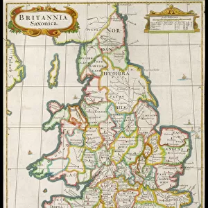
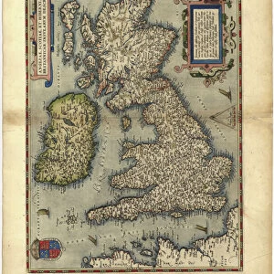
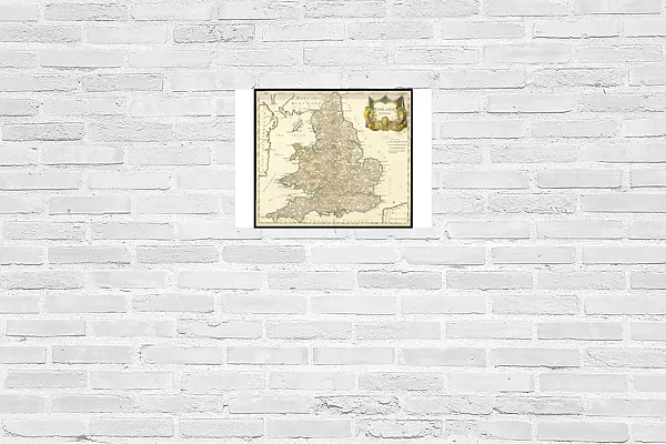
Poster Print : Map / England & Wales 1810


![]()
Poster Prints from Mary Evans Picture Library
Map / England & Wales 1810
England and Wales
Mary Evans Picture Library makes available wonderful images created for people to enjoy over the centuries
Media ID 573979
© Mary Evans Picture Library 2015 - https://copyrighthub.org/s0/hub1/creation/maryevans/MaryEvansPictureID/10009511
A2 (59.4 x 42cm) Poster Print
Discover the rich history of England and Wales in the 19th century with our stunning Map / England & Wales 1810 print from Mary Evans Picture Library. Part of our Media Storehouse collection, this poster print showcases intricate cartographical details, capturing the essence of a bygone era. Ideal for history enthusiasts, educators, and those who appreciate fine art, this print is a must-have for any room in your home or office. Bring a piece of the past into your present with this beautifully detailed and authentic representation of England and Wales in 1810.
A2 Poster (59.4 x 42cm, 23.4" x 16.5" inches) printed on 170gsm Satin Poster Paper. Securely packaged, rolled and inserted into a strong mailing tube and shipped tracked. Poster Prints are of comparable archival quality to our Photographic prints, they are simply printed on thinner Poster Paper. Whilst we only use Photographic Prints in our frames, you can frame Poster Prints if they are carefully supported to prevent sagging over time.
Poster prints are budget friendly enlarged prints in standard poster paper sizes (A0, A1, A2, A3 etc). Whilst poster paper is sometimes thinner and less durable than our other paper types, they are still ok for framing and should last many years. Our Archival Quality Photo Prints and Fine Art Paper Prints are printed on higher quality paper and the choice of which largely depends on your budget.
Estimated Image Size (if not cropped) is 47.7cm x 42cm (18.8" x 16.5")
Estimated Product Size is 59.4cm x 42cm (23.4" x 16.5")
These are individually made so all sizes are approximate
Artwork printed orientated as per the preview above, with landscape (horizontal) orientation to match the source image.
FEATURES IN THESE COLLECTIONS
> Mary Evans Prints Online
> Maps
> Europe
> United Kingdom
> England
> Maps
> Europe
> United Kingdom
> England
> Posters
> Europe
> United Kingdom
> England
> Related Images
> Europe
> United Kingdom
> Wales
> Maps
> Europe
> United Kingdom
> Wales
> Posters
> Europe
> United Kingdom
> Wales
> Related Images
> Maps and Charts
> Early Maps
> Maps and Charts
> Related Images
> Maps and Charts
> Wales
EDITORS COMMENTS
This map print, titled "England and Wales," dates back to the year 1810 and offers a fascinating glimpse into the historical geography of Britain during that era. Published during the Regency period, this map meticulously depicts the political boundaries and topographical features of England and Wales at the time. The map is adorned with intricate detail, revealing the counties, cities, towns, and villages that dotted the English and Welsh landscapes over two centuries ago. The River Thames, the Severn Estuary, and other major waterways are clearly marked, as are important roads and transportation routes. The border between England and Wales is distinctly demarcated, reflecting the political and cultural divide between the two countries. The map also includes a rich array of annotations and symbols, denoting various features such as coal mines, forests, and ancient monuments. The historical significance of this map is immense, as it provides valuable insight into the geographical and political landscape of England and Wales during a pivotal period in their shared history. The map's intricate detail and antique charm make it a captivating addition to any historical or cartographical collection. This map print, from the Mary Evans Picture Library, is a testament to the rich history and cultural heritage of England and Wales. Its intricate detail and historical accuracy make it an invaluable resource for scholars, historians, and anyone with an interest in the history of the British Isles. Whether displayed as a decorative piece or used for research purposes, this map print is sure to inspire wonder and fascination for generations to come.
MADE IN THE UK
Safe Shipping with 30 Day Money Back Guarantee
FREE PERSONALISATION*
We are proud to offer a range of customisation features including Personalised Captions, Color Filters and Picture Zoom Tools
SECURE PAYMENTS
We happily accept a wide range of payment options so you can pay for the things you need in the way that is most convenient for you
* Options may vary by product and licensing agreement. Zoomed Pictures can be adjusted in the Basket.