Poster Print > Maps and Charts > Early Maps
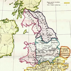
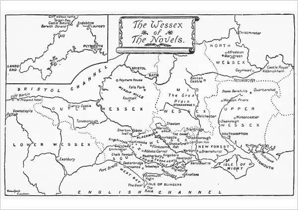
Poster Print : Map of Wessex


![]()
Poster Prints from Mary Evans Picture Library
Map of Wessex
A map of the Wessex of the novels
Mary Evans Picture Library makes available wonderful images created for people to enjoy over the centuries
Media ID 590984
© Mary Evans Picture Library 2015 - https://copyrighthub.org/s0/hub1/creation/maryevans/MaryEvansPictureID/10164775
A2 (59.4 x 42cm) Poster Print
Introducing the captivating collection of Map of Wessex poster prints from Media Storehouse, brought to you in collaboration with Mary Evans Picture Library from Mary Evans Prints Online. This beautiful poster depicts a map of the fictional county of Wessex, famously featured in the novels of Thomas Hardy. transport yourself to the heart of Hardy's literary world, adorn your walls with this evocative and intricately detailed map. Perfect for any literary or history enthusiast, this poster print adds an element of charm and sophistication to any room. Bring the timeless tales of Thomas Hardy to life with this exquisite and authentic reproduction.
A2 Poster (59.4 x 42cm, 23.4" x 16.5" inches) printed on 170gsm Satin Poster Paper. Securely packaged, rolled and inserted into a strong mailing tube and shipped tracked. Poster Prints are of comparable archival quality to our Photographic prints, they are simply printed on thinner Poster Paper. Whilst we only use Photographic Prints in our frames, you can frame Poster Prints if they are carefully supported to prevent sagging over time.
Poster prints are budget friendly enlarged prints in standard poster paper sizes (A0, A1, A2, A3 etc). Whilst poster paper is sometimes thinner and less durable than our other paper types, they are still ok for framing and should last many years. Our Archival Quality Photo Prints and Fine Art Paper Prints are printed on higher quality paper and the choice of which largely depends on your budget.
Estimated Image Size (if not cropped) is 59.4cm x 37.8cm (23.4" x 14.9")
Estimated Product Size is 59.4cm x 42cm (23.4" x 16.5")
These are individually made so all sizes are approximate
Artwork printed orientated as per the preview above, with landscape (horizontal) orientation to match the source image.
FEATURES IN THESE COLLECTIONS
> Maps and Charts
> Early Maps
> Maps and Charts
> Related Images
EDITORS COMMENTS
This stunning print of a Map of Wessex offers a glimpse into the world of Thomas Hardy's novels, bringing to life the historical setting of his beloved works. Published in 1872, this map showcases the intricate details and geographical features that inspired Hardy's storytelling.
Wessex, a fictional region created by Hardy, is depicted with precision and care on this beautifully crafted map. From rolling hills to quaint villages, every corner of this landscape exudes charm and character. As you trace your finger along its winding rivers and meandering roads, you can almost hear the echoes of Hardy's characters as they navigate through their tumultuous lives.
For fans of literature and history alike, this Map of Wessex serves as a visual treasure trove, offering insight into the rich tapestry of settings that shaped some of England's most iconic novels. Whether you're a seasoned reader familiar with Hardy's works or simply appreciate the beauty of cartography, this print is sure to captivate your imagination.
So take a moment to immerse yourself in the world of Wessex through this exquisite map - let it transport you back in time to an era where romance and tragedy intertwined amidst the rugged landscapes and picturesque villages. Let it be a reminder that sometimes, all it takes is a map to unlock the door to another world.
MADE IN THE UK
Safe Shipping with 30 Day Money Back Guarantee
FREE PERSONALISATION*
We are proud to offer a range of customisation features including Personalised Captions, Color Filters and Picture Zoom Tools
SECURE PAYMENTS
We happily accept a wide range of payment options so you can pay for the things you need in the way that is most convenient for you
* Options may vary by product and licensing agreement. Zoomed Pictures can be adjusted in the Basket.