Poster Print > Europe > France > Paris > Maps
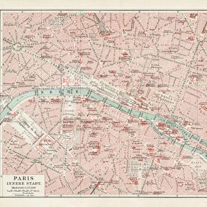
Poster Print : Map of Paris in 1908 with geographic and demographical data


![]()
Poster Prints from Mary Evans Picture Library
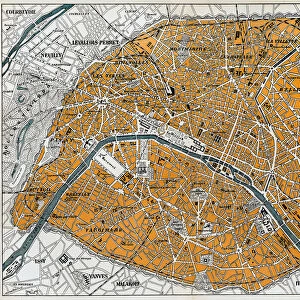
Map of Paris in 1908 with geographic and demographical data
Map of Paris in 1908 with geographic and demographic data featured (as well as the location of all of the major sites in the city centre). Date: 1908
Mary Evans Picture Library makes available wonderful images created for people to enjoy over the centuries
Media ID 14251044
© Mary Evans / Grenville Collins Postcard Collection
Data Demographic Geographic Locations Major Parisian Seine Sites Tourist
A2 (59.4 x 42cm) Poster Print
Discover the rich history of Paris with our stunning Map of Paris in 1908 from Media Storehouse. This exquisite poster print, sourced from Mary Evans Prints Online, showcases a detailed and intriguing map of the city, complete with geographic and demographic data. With the location of all major sites in the city center clearly marked, this print is an essential addition to any space inspired by the City of Light. Delve into the past and bring the history of Paris into your home or office.
A2 Poster (59.4 x 42cm, 23.4" x 16.5" inches) printed on 170gsm Satin Poster Paper. Securely packaged, rolled and inserted into a strong mailing tube and shipped tracked. Poster Prints are of comparable archival quality to our Photographic prints, they are simply printed on thinner Poster Paper. Whilst we only use Photographic Prints in our frames, you can frame Poster Prints if they are carefully supported to prevent sagging over time.
Poster prints are budget friendly enlarged prints in standard poster paper sizes (A0, A1, A2, A3 etc). Whilst poster paper is sometimes thinner and less durable than our other paper types, they are still ok for framing and should last many years. Our Archival Quality Photo Prints and Fine Art Paper Prints are printed on higher quality paper and the choice of which largely depends on your budget.
Estimated Image Size (if not cropped) is 59.4cm x 38.6cm (23.4" x 15.2")
Estimated Product Size is 59.4cm x 42cm (23.4" x 16.5")
These are individually made so all sizes are approximate
Artwork printed orientated as per the preview above, with landscape (horizontal) orientation to match the source image.
FEATURES IN THESE COLLECTIONS
> Arts
> Landscape paintings
> Waterfall and river artworks
> River artworks
> Europe
> France
> Paris
> Maps
> Europe
> France
> Paris
> Related Images
> Europe
> France
> Paris
> River Seine
> Maps and Charts
> Related Images
EDITORS COMMENTS
Step back in time and explore the vibrant and historic city of Paris as it appeared in 1908, with this intricately detailed map. The map provides an accurate representation of the city's geography during this period, including the winding paths of the Seine River and the layout of the city's many arrondissements. But this map is more than just a geographic representation, it also offers valuable demographic data, providing insights into the population density and distribution across the city. The map highlights the location of Paris's major sites, many of which remain popular tourist destinations today. The iconic Notre-Dame Cathedral, the Louvre Museum, and the Eiffel Tower are all clearly marked, inviting the viewer to imagine the bustling crowds that would have gathered around these landmarks over a century ago. The map also reveals the city's rich history and cultural heritage, with the location of various churches, markets, and historic monuments. The labyrinthine streets of the Latin Quarter, the elegant boulevards of the Marais, and the bohemian Montmartre district are all accounted for, offering a glimpse into the diverse and dynamic neighborhoods that make up this iconic city. As you explore this map of Paris in 1908, you'll gain a deeper appreciation for the city's rich history and the way it has evolved over time. From its iconic landmarks to its bustling streets and vibrant neighborhoods, this map offers a unique window into the past, inviting you to imagine the sights, sounds, and experiences of Paris a century ago.
MADE IN THE UK
Safe Shipping with 30 Day Money Back Guarantee
FREE PERSONALISATION*
We are proud to offer a range of customisation features including Personalised Captions, Color Filters and Picture Zoom Tools
SECURE PAYMENTS
We happily accept a wide range of payment options so you can pay for the things you need in the way that is most convenient for you
* Options may vary by product and licensing agreement. Zoomed Pictures can be adjusted in the Basket.