Poster Print > Europe > France > Canton > Allier
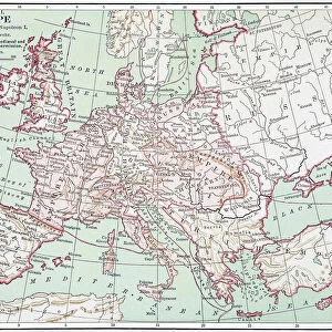
Poster Print : Map, Britain -- Spearhead of Attack, WW2


![]()
Poster Prints from Mary Evans Picture Library
Map, Britain -- Spearhead of Attack, WW2
Map, Britain -- Spearhead of Attack, WW2. Date: 1940s
Mary Evans Picture Library makes available wonderful images created for people to enjoy over the centuries
Media ID 14146038
© Mary Evans Picture Library/Onslow Auctions Limited
Allied Allies Attack Bombing Bombs Defence Effort Isles Manufacture Spearhead
A2 (59.4 x 42cm) Poster Print
Introducing the "Map, Britain -- Spearhead of Attack, WW2" print from the Media Storehouse collection, brought to you in partnership with Mary Evans Prints Online. This captivating image transports you back in time to the 1940s, providing a unique and insightful glimpse into the strategic planning of World War II. The map illustrates the British Isles with meticulous detail, adorned with annotations and markings that reveal the locations of key military installations and troop movements. The title "Spearhead of Attack" adds an intriguing sense of anticipation, inviting you to imagine the events that unfolded during this pivotal period in history. Each print is produced using premium materials and state-of-the-art printing techniques, ensuring vibrant colors and exceptional clarity that bring the image to life. This historic map print is not just a decorative piece, but a captivating window into the past, perfect for history enthusiasts, military buffs, or anyone with an appreciation for the richness of the world's historical records. Add a touch of history and intrigue to your home, office, or classroom with the "Map, Britain -- Spearhead of Attack, WW2" print from Media Storehouse. Order yours today!
A2 Poster (59.4 x 42cm, 23.4" x 16.5" inches) printed on 170gsm Satin Poster Paper. Securely packaged, rolled and inserted into a strong mailing tube and shipped tracked. Poster Prints are of comparable archival quality to our Photographic prints, they are simply printed on thinner Poster Paper. Whilst we only use Photographic Prints in our frames, you can frame Poster Prints if they are carefully supported to prevent sagging over time.
Poster prints are budget friendly enlarged prints in standard poster paper sizes (A0, A1, A2, A3 etc). Whilst poster paper is sometimes thinner and less durable than our other paper types, they are still ok for framing and should last many years. Our Archival Quality Photo Prints and Fine Art Paper Prints are printed on higher quality paper and the choice of which largely depends on your budget.
Estimated Image Size (if not cropped) is 59.4cm x 39.3cm (23.4" x 15.5")
Estimated Product Size is 59.4cm x 42cm (23.4" x 16.5")
These are individually made so all sizes are approximate
Artwork printed orientated as per the preview above, with landscape (horizontal) orientation to match the source image.
FEATURES IN THESE COLLECTIONS
> Animals
> Mammals
> Muridae
> Fortior
> Europe
> France
> Canton
> Allier
> Europe
> Related Images
> Europe
> Republic of Ireland
> Maps
> Europe
> United Kingdom
> Maps
> Historic
> World War I and II
> World War II
> Maps and Charts
> Early Maps
EDITORS COMMENTS
This evocative map print, titled "Map, Britain -- Spearhead of Attack, WW2," transports us back in time to the tumultuous 1940s during the Second World War. The intricate detail of the map reveals the strategic locations of the British Isles, Ireland, and parts of Europe, with a particular focus on the United Kingdom. The map serves as a testament to the critical role Britain played during this global conflict. The map is adorned with various symbols and notations, indicating key military installations, ports, and industrial centers. The red dots scattered across the map represent bombing raids, a stark reminder of the relentless air attacks that the British people endured. The presence of the British, American, and Allied flags signifies the unity and solidarity of the Allied forces in their joint efforts to defend against the Axis powers, primarily Germany. The map also highlights the importance of the British Navy, with various naval bases and shipping routes marked. The Royal Navy was instrumental in protecting the British Isles from invasion and maintaining the supply lines to the Allied forces in Europe. This map print offers a unique perspective on the historical context of the 1940s, showcasing the intricate planning and strategic maneuvers that were essential to the war effort. The intricate details and accurate depictions make it an invaluable resource for historians, military enthusiasts, and anyone interested in understanding the complexities of the Second World War.
MADE IN THE UK
Safe Shipping with 30 Day Money Back Guarantee
FREE PERSONALISATION*
We are proud to offer a range of customisation features including Personalised Captions, Color Filters and Picture Zoom Tools
SECURE PAYMENTS
We happily accept a wide range of payment options so you can pay for the things you need in the way that is most convenient for you
* Options may vary by product and licensing agreement. Zoomed Pictures can be adjusted in the Basket.