Poster Print > Arts > Artists > W > Nicolaes Witsen
Poster Print : Map MagnAŠ TartariAŠ magni Mogolis imperii IaponiAŠ et ChinAŠ


![]()
Poster Prints from Liszt Collection
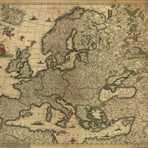
Map MagnAŠ TartariAŠ magni Mogolis imperii IaponiAŠ et ChinAŠ
Map, Magnae Tartariae, magni Mogolis imperii, Iaponiae et Chinae, nova descriptio ex tabula... D.N. Witsen... per F. de Witt, Frederick de Wit (1630-1706), Nicolaes Witsen (1641-1717), Copperplate print
Liszt Collection of nineteenth-century engravings and images to browse and enjoy
Media ID 19585053
© Artokoloro
1630 1706 Copperplate Print Frederick De Wit De Witt Nicolaes Witsen Witsen
A2 (59.4 x 42cm) Poster Print
Step back in time with our exquisite Map MagnAŠ TartariAŠ magni Mogolis imperii IaponiAŠ et ChinAŠ print from the renowned Liszt Collection. This stunning poster, derived from the original map created by Frederick de Wit and Nicolaes Witsen in 1652, offers a captivating glimpse into the historical geography of the Mughal Empire in India and China. The intricate details and vibrant colors bring the rich history of this region to life, making it a perfect addition to any home or office space. Immerse yourself in the beauty and depth of this historical masterpiece and transport yourself to a different era.
A2 Poster (59.4 x 42cm, 23.4" x 16.5" inches) printed on 170gsm Satin Poster Paper. Securely packaged, rolled and inserted into a strong mailing tube and shipped tracked. Poster Prints are of comparable archival quality to our Photographic prints, they are simply printed on thinner Poster Paper. Whilst we only use Photographic Prints in our frames, you can frame Poster Prints if they are carefully supported to prevent sagging over time.
Poster prints are budget friendly enlarged prints in standard poster paper sizes (A0, A1, A2, A3 etc). Whilst poster paper is sometimes thinner and less durable than our other paper types, they are still ok for framing and should last many years. Our Archival Quality Photo Prints and Fine Art Paper Prints are printed on higher quality paper and the choice of which largely depends on your budget.
Estimated Image Size (if not cropped) is 50.3cm x 42cm (19.8" x 16.5")
Estimated Product Size is 59.4cm x 42cm (23.4" x 16.5")
These are individually made so all sizes are approximate
Artwork printed orientated as per the preview above, with landscape (horizontal) orientation to match the source image.
FEATURES IN THESE COLLECTIONS
> Arts
> Artists
> W
> Frederick de Wit
> Arts
> Artists
> W
> Nicolaes Witsen
> Maps and Charts
> Related Images
EDITORS COMMENTS
This print showcases a historical map titled "Map Magnæ Tartariæ, magni Mogolis imperii, Iaponiæ et Chinæ". Created by the renowned cartographers Frederick de Wit and Nicolaes Witsen in the 17th century, this copperplate print is a true masterpiece. The intricate details of this map transport us back to an era when exploration and discovery were at their peak. The vast territories of Tartary, the mighty Mongol Empire, Japan, and China are meticulously depicted with precision and artistry. Every stroke on this print tells a story of adventure and curiosity. As we gaze upon this remarkable piece of history, we can't help but marvel at the skillful craftsmanship that went into its creation. The delicate lines forming coastlines, rivers, mountains, and cities showcase the immense knowledge these cartographers possessed about distant lands. This print from Liszt Collection serves as a window into a world long gone—a testament to human ingenuity in mapping uncharted territories. It reminds us of our ancestors' relentless pursuit of knowledge and their desire to understand the vastness of our planet. Whether you are an avid historian or simply appreciate exquisite artwork, this map print will undoubtedly captivate your imagination. Let it take you on a journey through time as you explore the ancient realms depicted within its borders.
MADE IN THE UK
Safe Shipping with 30 Day Money Back Guarantee
FREE PERSONALISATION*
We are proud to offer a range of customisation features including Personalised Captions, Color Filters and Picture Zoom Tools
SECURE PAYMENTS
We happily accept a wide range of payment options so you can pay for the things you need in the way that is most convenient for you
* Options may vary by product and licensing agreement. Zoomed Pictures can be adjusted in the Basket.