Poster Print > Liszt Collection > Engravings
Poster Print : Source Size = 1824 x 2744


![]()
Poster Prints from Liszt Collection
Source Size = 1824 x 2744
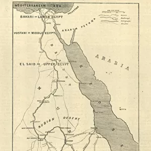
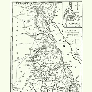
The Rebellion in the Soudan (Sudan): Map Showing Upper Egypt and the Seat of the Revolt, the Routes Across the Desert to Khartoum, and the Towns where Egyptian Garrisons are Beleaguered
Liszt Collection of nineteenth-century engravings and images to browse and enjoy
Media ID 12972539
© Quint Lox Limited
Abandon Desert Egyptian Insurrection Khartoum Leave Plan Rebellion Revolt Seat Showing Soudan Sudan Towns Upper Uprising Beleaguered Routes
A2 (59.4 x 42cm) Poster Print
Discover the captivating history of the Sudan Rebellion with our stunning poster prints from the Media Storehouse Liszt Collection. This particular print showcases an intriguing map titled "The Rebellion in the Soudan (Sudan): Map Showing Upper Egypt and the Seat of the Revolt." The map illustrates the key locations of the Egyptian garrisons under siege and the treacherous desert routes leading to Khartoum. Bring history to life in your home or office with this beautifully detailed and historically significant poster print.
A2 Poster (59.4 x 42cm, 23.4" x 16.5" inches) printed on 170gsm Satin Poster Paper. Securely packaged, rolled and inserted into a strong mailing tube and shipped tracked. Poster Prints are of comparable archival quality to our Photographic prints, they are simply printed on thinner Poster Paper. Whilst we only use Photographic Prints in our frames, you can frame Poster Prints if they are carefully supported to prevent sagging over time.
Poster prints are budget friendly enlarged prints in standard poster paper sizes (A0, A1, A2, A3 etc). Whilst poster paper is sometimes thinner and less durable than our other paper types, they are still ok for framing and should last many years. Our Archival Quality Photo Prints and Fine Art Paper Prints are printed on higher quality paper and the choice of which largely depends on your budget.
Estimated Image Size (if not cropped) is 38.7cm x 59.4cm (15.2" x 23.4")
Estimated Product Size is 42cm x 59.4cm (16.5" x 23.4")
These are individually made so all sizes are approximate
Artwork printed orientated as per the preview above, with portrait (vertical) orientation to match the source image.
EDITORS COMMENTS
This vintage print titled "The Rebellion in the Soudan: Map Showing Upper Egypt and the Seat of the Revolt" takes us back to a significant period in history. The intricately engraved image, with its retro-styled charm, offers a glimpse into the insurrection that unfolded in Sudan during Victorian times. With a source size of 1824 x 2744 pixels, this print showcases an illustrative technique that brings to life the rebellion's key elements. The detailed map highlights not only Upper Egypt but also Khartoum, where Egyptian garrisons faced immense challenges from rebellious forces. It meticulously outlines the routes across the desert that were used by both sides during this tumultuous time. The visual narrative captures the tension and turmoil of an uprising as towns are beleaguered and Egyptian garrisons find themselves isolated and under siege. This historical artifact serves as a valuable resource for those interested in studying this pivotal event. As we gaze upon this evocative piece from Liszt Collection's archives, it reminds us of how art can preserve moments from our past. It transports us to another era while offering insights into cultural perspectives and artistic techniques prevalent at that time.
MADE IN THE UK
Safe Shipping with 30 Day Money Back Guarantee
FREE PERSONALISATION*
We are proud to offer a range of customisation features including Personalised Captions, Color Filters and Picture Zoom Tools
SECURE PAYMENTS
We happily accept a wide range of payment options so you can pay for the things you need in the way that is most convenient for you
* Options may vary by product and licensing agreement. Zoomed Pictures can be adjusted in the Basket.