Poster Print > Asia > China > Maps
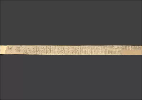
Poster Print : The Dunhuang Star map, ca 700. Artist: Anonymous master


![]()
Poster Prints from Heritage Images
The Dunhuang Star map, ca 700. Artist: Anonymous master
The Dunhuang Star map, ca 700. Found in the collection of the British Library
Heritage Images features heritage image collections
Media ID 15015614
© Fine Art Images
Anonymous Master British Library Cartography Ink On Paper Tang Dynasty
A2 (59.4 x 42cm) Poster Print
Discover the mysteries of ancient astronomy with our exquisite poster prints from Media Storehouse. Feast your eyes on the intricately detailed Dunhuang Star Map, dating back to around 700 AD. This rare and captivating artwork, sourced from the prestigious British Library, showcases the advanced knowledge of the stars and constellations held by the Anonymous master of that time. Bring a piece of history into your home or office with this stunning, museum-quality poster print. Order yours today and embark on a celestial journey through the ages.
A2 Poster (59.4 x 42cm, 23.4" x 16.5" inches) printed on 170gsm Satin Poster Paper. Securely packaged, rolled and inserted into a strong mailing tube and shipped tracked. Poster Prints are of comparable archival quality to our Photographic prints, they are simply printed on thinner Poster Paper. Whilst we only use Photographic Prints in our frames, you can frame Poster Prints if they are carefully supported to prevent sagging over time.
Poster prints are budget friendly enlarged prints in standard poster paper sizes (A0, A1, A2, A3 etc). Whilst poster paper is sometimes thinner and less durable than our other paper types, they are still ok for framing and should last many years. Our Archival Quality Photo Prints and Fine Art Paper Prints are printed on higher quality paper and the choice of which largely depends on your budget.
Estimated Image Size (if not cropped) is 59.4cm x 4cm (23.4" x 1.6")
Estimated Product Size is 59.4cm x 42cm (23.4" x 16.5")
These are individually made so all sizes are approximate
Artwork printed orientated as per the preview above, with landscape (horizontal) orientation to match the source image.
FEATURES IN THESE COLLECTIONS
> Historic
> Ancient civilizations
> Chinese Dynasties
> Historic
> Chinese dynasties paintings
> Maps and Charts
> Related Images
> Maps and Charts
> Star Charts
EDITORS COMMENTS
This print showcases "The Dunhuang Star map" a remarkable piece of ancient Chinese artistry and scientific knowledge. Created around 700 AD during the Tang Dynasty, this anonymous masterpiece is now housed in the esteemed collection of the British Library. Intricately detailed and delicately rendered with ink on paper, this fine example of graphic arts offers a fascinating glimpse into China's rich history of astronomy and cartography. The Dunhuang Star map presents an intricate network of stars, constellations, and celestial bodies meticulously charted by an unknown master artist. As we explore this extraordinary artwork, we are transported back in time to an era when humans sought to understand the vastness of our universe. This star chart not only served as a navigational tool but also reflected the profound connection between heaven and earth within Chinese culture. The significance of The Dunhuang Star map lies not only in its historical value but also in its artistic brilliance. Its elegant lines and meticulous details demonstrate the skillful craftsmanship that flourished during the Tang Dynasty. Through this photo print, we can appreciate both the beauty and intellectual prowess embedded within ancient Chinese astronomical studies. It serves as a testament to human curiosity, ingenuity, and our ceaseless quest for knowledge about our place in the cosmos.
MADE IN THE UK
Safe Shipping with 30 Day Money Back Guarantee
FREE PERSONALISATION*
We are proud to offer a range of customisation features including Personalised Captions, Color Filters and Picture Zoom Tools
SECURE PAYMENTS
We happily accept a wide range of payment options so you can pay for the things you need in the way that is most convenient for you
* Options may vary by product and licensing agreement. Zoomed Pictures can be adjusted in the Basket.