Poster Print > Europe > Iceland > Maps
Poster Print : MAP: ICELAND, 1958. Map of Iceland published by the Central Intelligence Agency, 1958


![]()
Poster Prints from Granger
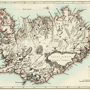
MAP: ICELAND, 1958. Map of Iceland published by the Central Intelligence Agency, 1958
MAP: ICELAND, 1958.
Map of Iceland published by the Central Intelligence Agency, 1958
Granger holds millions of images spanning more than 25,000 years of world history, from before the Stone Age to the dawn of the Space Age
Media ID 13637050
1958 Iceland Icelandic Island Print
A2 (59.4 x 42cm) Poster Print
Step back in time with our vintage Map: Iceland, 1958 print from Granger, NYC / The Granger Collection. This intriguing poster showcases an historical map of Iceland, originally published by the Central Intelligence Agency in 1958. Add an element of nostalgia and geographical charm to your space with this unique and authentic piece from Granger Art on Demand.
A2 Poster (59.4 x 42cm, 23.4" x 16.5" inches) printed on 170gsm Satin Poster Paper. Securely packaged, rolled and inserted into a strong mailing tube and shipped tracked. Poster Prints are of comparable archival quality to our Photographic prints, they are simply printed on thinner Poster Paper. Whilst we only use Photographic Prints in our frames, you can frame Poster Prints if they are carefully supported to prevent sagging over time.
Poster prints are budget friendly enlarged prints in standard poster paper sizes (A0, A1, A2, A3 etc). Whilst poster paper is sometimes thinner and less durable than our other paper types, they are still ok for framing and should last many years. Our Archival Quality Photo Prints and Fine Art Paper Prints are printed on higher quality paper and the choice of which largely depends on your budget.
Estimated Image Size (if not cropped) is 56.6cm x 42cm (22.3" x 16.5")
Estimated Product Size is 59.4cm x 42cm (23.4" x 16.5")
These are individually made so all sizes are approximate
Artwork printed orientated as per the preview above, with landscape (horizontal) orientation to match the source image.
FEATURES IN THESE COLLECTIONS
> Europe
> Iceland
> Related Images
> Maps and Charts
> Related Images
EDITORS COMMENTS
This print showcases a remarkable piece of history - the Map of Iceland published by the Central Intelligence Agency in 1958. With its intricate details and expertly crafted illustration, this map offers a glimpse into the past, transporting us to an era when cartography was both an art form and a vital tool for intelligence agencies. The map itself is a testament to the meticulousness of the CIA's work during that time. Every contour, river, and town is meticulously labeled, providing valuable information about Iceland's geography and topography. It serves as a window into understanding how our knowledge of this beautiful island nation has evolved over time. The significance of this particular map lies not only in its historical context but also in its artistic merit. The attention to detail is awe-inspiring; each stroke carefully placed to create an accurate representation of Iceland's landscape. From sprawling glaciers to rugged coastlines, every feature comes alive on this printed masterpiece. Granger Art on Demand has done justice to preserving this invaluable artifact with their high-quality print. The clarity and vibrancy allow viewers to appreciate every minute detail while immersing themselves in the rich history it represents. Whether you are an avid collector or simply fascinated by maps and history, this stunning print will undoubtedly be a cherished addition to any space. It serves as a reminder that even seemingly ordinary objects can hold immense value when viewed through the lens of time and appreciation for craftsmanship.
MADE IN THE UK
Safe Shipping with 30 Day Money Back Guarantee
FREE PERSONALISATION*
We are proud to offer a range of customisation features including Personalised Captions, Color Filters and Picture Zoom Tools
SECURE PAYMENTS
We happily accept a wide range of payment options so you can pay for the things you need in the way that is most convenient for you
* Options may vary by product and licensing agreement. Zoomed Pictures can be adjusted in the Basket.