Poster Print > Animals > Fishes > S > Sea Devil
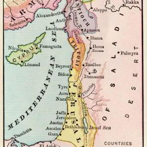
Poster Print : Middle East Ancient Map, Garden of Eden, 1675


![]()
Poster Prints from Fine Art Storehouse
Middle East Ancient Map, Garden of Eden, 1675
This may appear to be a straightforward map of the Middle East. However, closer inspection will reveal some extraordinary details, a number of descriptions on the map refer to stories from the Bible
Unleash your creativity and transform your space into a visual masterpiece!
BernardAllum
Media ID 15311440
© BernardAllum
Anatolia Angel Arabia Babil Beginnings Bible Bible Stories Cyprus Desert Devil Egypt Garden Of Eden Old Testament Globe Man Made Object Heaven Islam Israel Jacob Jerusalem Kingdom Medina District Mediterranean Sea Middle East Middle Eastern Ethnicity Noah Old Testament Parchment Persian Gulf Persian Gulf Countries Protestantism Red Sea Religious Text Syria Adam And Eve Euphrates River Retro Styled Tigris River Tower Of Babel War Zone
A2 (59.4 x 42cm) Poster Print
Step back in time with our exquisite Middle East Ancient Map, a captivating masterpiece from the Fine Art Storehouse by Bernard Allum. This 1675 map appears to be a traditional representation of the Middle East, but a closer look reveals intriguing biblical references. Embellishing the landscape are descriptions of places like the Garden of Eden, the River Euphrates, and the Red Sea. Bring the stories of the Bible to life in your home or office with this stunning and historically significant poster print. An extraordinary addition to any collection.
A2 Poster (59.4 x 42cm, 23.4" x 16.5" inches) printed on 170gsm Satin Poster Paper. Securely packaged, rolled and inserted into a strong mailing tube and shipped tracked. Poster Prints are of comparable archival quality to our Photographic prints, they are simply printed on thinner Poster Paper. Whilst we only use Photographic Prints in our frames, you can frame Poster Prints if they are carefully supported to prevent sagging over time.
Poster prints are budget friendly enlarged prints in standard poster paper sizes (A0, A1, A2, A3 etc). Whilst poster paper is sometimes thinner and less durable than our other paper types, they are still ok for framing and should last many years. Our Archival Quality Photo Prints and Fine Art Paper Prints are printed on higher quality paper and the choice of which largely depends on your budget.
Estimated Product Size is 59.4cm x 42cm (23.4" x 16.5")
These are individually made so all sizes are approximate
Artwork printed orientated as per the preview above, with landscape (horizontal) orientation to match the source image.
FEATURES IN THESE COLLECTIONS
> Fine Art Storehouse
> Map
> Historical Maps
> Fine Art Storehouse
> World Religion
> Africa
> Egypt
> Related Images
> Animals
> Fishes
> S
> Sea Devil
> Animals
> Mammals
> Muridae
> Desert Mouse
> Arts
> Artists
> J
> Jacob Jacobs
> Arts
> Artists
> S
> Syrian Syrian
> Arts
> Landscape paintings
> Waterfall and river artworks
> River artworks
> Asia
> Cyprus
> Related Images
EDITORS COMMENTS
This print titled "Middle East Ancient Map, Garden of Eden, 1675" takes viewers on a journey through time and faith. At first glance, it appears to be a traditional map of the Middle East, but upon closer inspection, extraordinary details emerge that connect this cartographic masterpiece to stories from the Bible. The intricate descriptions scattered across the map transport us back to ancient times when religious texts shaped civilizations. From the Euphrates River to the Tigris River, from Babylon to Anatolia, every landmark holds significance in biblical narratives. The Garden of Eden itself is depicted with an idyllic charm that evokes images of paradise lost. As we explore further into this retro-styled parchment artwork, we encounter references to Noah's Ark and Jacob's ladder. The Tower of Babel stands tall amidst other landmarks in this historical landscape. These symbols not only represent Protestantism and Old Testament tales but also bridge gaps between Islam and Christianity - two major religions deeply rooted in Middle Eastern ethnicity. This antique piece serves as a testament to history and religion intertwined. It reminds us of our shared beginnings and highlights how faith has shaped cultures over centuries. With Syria, Jerusalem, Israel, Arabia, Cyprus, Egypt all present on this map alongside heavenly figures like angels and even depictions of God and the devil themselves - it becomes clear that these lands have long been at the center stage of human spirituality. Bernard Allum's artistic creation transports us beyond geographical boundaries; it invites contemplation about
MADE IN THE UK
Safe Shipping with 30 Day Money Back Guarantee
FREE PERSONALISATION*
We are proud to offer a range of customisation features including Personalised Captions, Color Filters and Picture Zoom Tools
SECURE PAYMENTS
We happily accept a wide range of payment options so you can pay for the things you need in the way that is most convenient for you
* Options may vary by product and licensing agreement. Zoomed Pictures can be adjusted in the Basket.