Poster Print > Europe > United Kingdom > Related Images
Poster Print : United Kingdom country map


![]()
Poster Prints from Fine Art Storehouse
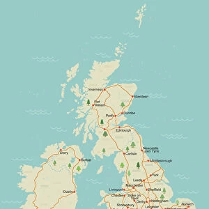
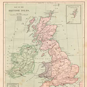
United Kingdom country map
2011 edition
Unleash your creativity and transform your space into a visual masterpiece!
Media ID 14432157
A2 (59.4 x 42cm) Poster Print
Discover the beauty of the United Kingdom with our exquisite Fine Art Storehouse Poster Print of the country map. This 2011 edition poster is a stunning addition to any room, showcasing intricate details of the United Kingdom's borders, cities, and regions. Bring a piece of British history and culture into your home or office with this high-quality, museum-grade print. Each print is carefully produced using archival inks and heavyweight paper, ensuring vibrant colors and longevity. Transport yourself to the land of castles, rolling hills, and rich history with this beautiful United Kingdom map poster from Media Storehouse.
A2 Poster (59.4 x 42cm, 23.4" x 16.5" inches) printed on 170gsm Satin Poster Paper. Securely packaged, rolled and inserted into a strong mailing tube and shipped tracked. Poster Prints are of comparable archival quality to our Photographic prints, they are simply printed on thinner Poster Paper. Whilst we only use Photographic Prints in our frames, you can frame Poster Prints if they are carefully supported to prevent sagging over time.
Poster prints are budget friendly enlarged prints in standard poster paper sizes (A0, A1, A2, A3 etc). Whilst poster paper is sometimes thinner and less durable than our other paper types, they are still ok for framing and should last many years. Our Archival Quality Photo Prints and Fine Art Paper Prints are printed on higher quality paper and the choice of which largely depends on your budget.
Estimated Image Size (if not cropped) is 42cm x 55.5cm (16.5" x 21.9")
Estimated Product Size is 42cm x 59.4cm (16.5" x 23.4")
These are individually made so all sizes are approximate
Artwork printed orientated as per the preview above, with portrait (vertical) orientation to match the source image.
FEATURES IN THESE COLLECTIONS
> Fine Art Storehouse
> Map
> Reference Maps
> Europe
> United Kingdom
> Related Images
> Maps and Charts
> Related Images
EDITORS COMMENTS
This print showcases the United Kingdom country map, specifically the 2011 edition. With intricate details and vibrant colors, this piece from Fine Art Storehouse is a true masterpiece that captures the essence of this historic nation. The map itself is meticulously crafted, highlighting every city, town, and village across England, Scotland, Wales, and Northern Ireland. From bustling metropolises like London and Edinburgh to charming coastal towns like Brighton and St Ives - each location is clearly marked with precision. What makes this particular print stand out is its ability to transport you into a world of exploration. As your eyes wander across the map's surface, you can't help but imagine embarking on an adventure through these diverse landscapes. Whether it's hiking in the breathtaking Scottish Highlands or exploring ancient castles in Wales - there are endless possibilities waiting to be discovered within these borders. As you admire this artwork on your wall or desk, it serves as a constant reminder of the rich history and cultural heritage that defines the United Kingdom. It sparks curiosity about its people, traditions, landmarks, and even local delicacies such as fish and chips or haggis! This print from Fine Art Storehouse encapsulates more than just geographical information; it captures a sense of national pride for those who call this beautiful island home or have fond memories of their time spent here.
MADE IN THE UK
Safe Shipping with 30 Day Money Back Guarantee
FREE PERSONALISATION*
We are proud to offer a range of customisation features including Personalised Captions, Color Filters and Picture Zoom Tools
SECURE PAYMENTS
We happily accept a wide range of payment options so you can pay for the things you need in the way that is most convenient for you
* Options may vary by product and licensing agreement. Zoomed Pictures can be adjusted in the Basket.