Poster Print > Europe > Norway > Maps
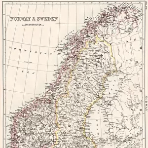
Poster Print : Map of Sweden and Norway 1896


![]()
Poster Prints from Fine Art Storehouse
Map of Sweden and Norway 1896
Andres Allgemeiner Handatlas - Bielefeld und Leipzig 1896
Unleash your creativity and transform your space into a visual masterpiece!
THEPALMER
Media ID 18356817
A2 (59.4 x 42cm) Poster Print
Step back in time with our stunning vintage Map of Sweden and Norway from ThePalmer's Andres Allgemeiner Handatlas, published in 1896. This beautiful poster print showcases intricate detail and historical accuracy, transporting you to a bygone era. Perfect for history enthusiasts, world travelers, or anyone who appreciates the beauty of vintage cartography. Bring this piece of history into your home or office and add a touch of timeless charm to your space.
A2 Poster (59.4 x 42cm, 23.4" x 16.5" inches) printed on 170gsm Satin Poster Paper. Securely packaged, rolled and inserted into a strong mailing tube and shipped tracked. Poster Prints are of comparable archival quality to our Photographic prints, they are simply printed on thinner Poster Paper. Whilst we only use Photographic Prints in our frames, you can frame Poster Prints if they are carefully supported to prevent sagging over time.
Poster prints are budget friendly enlarged prints in standard poster paper sizes (A0, A1, A2, A3 etc). Whilst poster paper is sometimes thinner and less durable than our other paper types, they are still ok for framing and should last many years. Our Archival Quality Photo Prints and Fine Art Paper Prints are printed on higher quality paper and the choice of which largely depends on your budget.
Estimated Image Size (if not cropped) is 53.9cm x 42cm (21.2" x 16.5")
Estimated Product Size is 59.4cm x 42cm (23.4" x 16.5")
These are individually made so all sizes are approximate
Artwork printed orientated as per the preview above, with landscape (horizontal) orientation to match the source image.
FEATURES IN THESE COLLECTIONS
> Fine Art Storehouse
> Map
> Historical Maps
> Europe
> Norway
> Related Images
> Europe
> Sweden
> Related Images
> Maps and Charts
> Related Images
EDITORS COMMENTS
This print showcases a remarkable piece of history, the "Map of Sweden and Norway 1896" from Andres Allgemeiner Handatlas. A true testament to cartographic excellence, this map offers a glimpse into the past, transporting us back to the late 19th century. The intricate details and craftsmanship displayed in this print are truly awe-inspiring. Every contour, river, and mountain range is meticulously depicted with utmost precision. The delicate strokes of ink bring life to each city and town, inviting us to explore these Scandinavian lands as they were over a century ago. As we delve into this vintage map, we can't help but marvel at how much has changed since its creation. Borders have shifted, cities have expanded or transformed entirely; yet amidst all these changes lies an undeniable sense of nostalgia for simpler times. "The Map of Sweden and Norway 1896" by THEPALMER serves as both a historical artifact and a work of art. It reminds us that maps not only guide our physical journeys but also allow us to embark on voyages through time itself. Whether you're an avid collector or simply appreciate the beauty found in antique cartography, this print is sure to captivate your imagination while providing an intriguing window into Scandinavia's rich heritage.
MADE IN THE UK
Safe Shipping with 30 Day Money Back Guarantee
FREE PERSONALISATION*
We are proud to offer a range of customisation features including Personalised Captions, Color Filters and Picture Zoom Tools
SECURE PAYMENTS
We happily accept a wide range of payment options so you can pay for the things you need in the way that is most convenient for you
* Options may vary by product and licensing agreement. Zoomed Pictures can be adjusted in the Basket.