Poster Print > Fine Art Storehouse > Map
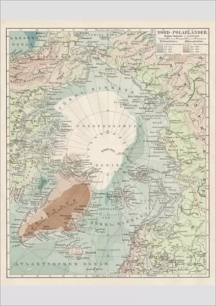
Poster Print : Map of North Pole 1900


![]()
Poster Prints from Fine Art Storehouse
Map of North Pole 1900
Meyers hand-Atlas Leipzig und Wien Verlag des Bibliographischen Instituts 1900
Unleash your creativity and transform your space into a visual masterpiece!
THEPALMER
Media ID 18356599
A2 (59.4 x 42cm) Poster Print
Discover the captivating history of exploration with our exquisite "Map of the North Pole 1900" by THEPALMER from our Media Storehouse Fine Art Prints collection. This rare and intriguing poster, taken from the esteemed Meyers Hand-Atlas published by the Bibliographisches Institut in Leipzig and Wien, showcases the vast, unexplored territories of the North Pole as understood in 1900. Bring a piece of historical cartography into your home or office, and transport yourself back in time with this beautiful and informative work of art.
A2 Poster (59.4 x 42cm, 23.4" x 16.5" inches) printed on 170gsm Satin Poster Paper. Securely packaged, rolled and inserted into a strong mailing tube and shipped tracked. Poster Prints are of comparable archival quality to our Photographic prints, they are simply printed on thinner Poster Paper. Whilst we only use Photographic Prints in our frames, you can frame Poster Prints if they are carefully supported to prevent sagging over time.
Poster prints are budget friendly enlarged prints in standard poster paper sizes (A0, A1, A2, A3 etc). Whilst poster paper is sometimes thinner and less durable than our other paper types, they are still ok for framing and should last many years. Our Archival Quality Photo Prints and Fine Art Paper Prints are printed on higher quality paper and the choice of which largely depends on your budget.
Estimated Image Size (if not cropped) is 42cm x 51.5cm (16.5" x 20.3")
Estimated Product Size is 42cm x 59.4cm (16.5" x 23.4")
These are individually made so all sizes are approximate
Artwork printed orientated as per the preview above, with portrait (vertical) orientation to match the source image.
FEATURES IN THESE COLLECTIONS
> Fine Art Storehouse
> Map
> Historical Maps
EDITORS COMMENTS
In this photo print, titled "Map of North Pole 1900". THEPALMER takes us on a journey back in time to the turn of the century. The image showcases an exquisite map from Meyers hand-Atlas Leipzig und Wien Verlag des Bibliographischen Instituts, dating all the way back to 1900. As we gaze upon this vintage piece, we are transported to an era when exploration and discovery were at their peak. The map itself is a testament to human curiosity and ambition, depicting the vast icy landscapes that make up the mysterious North Pole. The attention to detail in this print is truly remarkable - every contour line and geographical feature has been meticulously captured by THEPALMER's lens. The faded colors and delicate lines evoke a sense of nostalgia, reminding us of a time when cartography was both artistry and science. This photograph not only serves as a visual delight but also sparks our imagination about what lies beyond those frozen horizons. It invites us to ponder upon the brave explorers who ventured into these uncharted territories with nothing more than determination and sheer willpower. "The Map of North Pole 1900" by THEPALMER is not just a historical artifact; it is a window into our past, offering glimpses into an age where maps held secrets waiting to be unraveled. Through this photo print, we can appreciate both the beauty of antique cartography and its significance in shaping our understanding of the world around us.
MADE IN THE UK
Safe Shipping with 30 Day Money Back Guarantee
FREE PERSONALISATION*
We are proud to offer a range of customisation features including Personalised Captions, Color Filters and Picture Zoom Tools
SECURE PAYMENTS
We happily accept a wide range of payment options so you can pay for the things you need in the way that is most convenient for you
* Options may vary by product and licensing agreement. Zoomed Pictures can be adjusted in the Basket.