Poster Print > Arts > Artists > I > Irish School Irish School
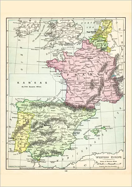
Poster Print : Map of Europe 1895


![]()
Poster Prints from Fine Art Storehouse
Map of Europe 1895
The Rand-McNally Grammar School Geography 1895 - Chicago & New York
Unleash your creativity and transform your space into a visual masterpiece!
THEPALMER
Media ID 14824645
© This content is subject to copyright
Ireland Mediterranean Portugal
A2 (59.4 x 42cm) Poster Print
Step back in time with our vintage Map of Europe 1895 print from ThePalmer, available in the Media Storehouse Poster Prints collection. This captivating piece, originally published by Rand-McNally for grammar school use in Chicago and New York in 1895, showcases intricate details of Europe's political landscape during that era. Add a touch of history and elegance to your space with this beautiful and informative poster print.
A2 Poster (59.4 x 42cm, 23.4" x 16.5" inches) printed on 170gsm Satin Poster Paper. Securely packaged, rolled and inserted into a strong mailing tube and shipped tracked. Poster Prints are of comparable archival quality to our Photographic prints, they are simply printed on thinner Poster Paper. Whilst we only use Photographic Prints in our frames, you can frame Poster Prints if they are carefully supported to prevent sagging over time.
Poster prints are budget friendly enlarged prints in standard poster paper sizes (A0, A1, A2, A3 etc). Whilst poster paper is sometimes thinner and less durable than our other paper types, they are still ok for framing and should last many years. Our Archival Quality Photo Prints and Fine Art Paper Prints are printed on higher quality paper and the choice of which largely depends on your budget.
Estimated Image Size (if not cropped) is 42cm x 51.5cm (16.5" x 20.3")
Estimated Product Size is 42cm x 59.4cm (16.5" x 23.4")
These are individually made so all sizes are approximate
Artwork printed orientated as per the preview above, with portrait (vertical) orientation to match the source image.
FEATURES IN THESE COLLECTIONS
> Fine Art Storehouse
> Map
> Historical Maps
> Arts
> Artists
> I
> Irish School Irish School
> Arts
> Artists
> P
> Portuguese School
> Arts
> Artists
> S
> Spanish School
> Europe
> Germany
> Related Images
> Europe
> Portugal
> Related Images
EDITORS COMMENTS
In this print titled "Map of Europe 1895" we are transported back in time to the late 19th century. The map, sourced from "The Rand-McNally Grammar School Geography 1895" publication, takes us on a visual journey through Europe as it was known over a century ago. Expertly captured by THEPALMER and made available by Fine Art Storehouse, this vintage piece offers a glimpse into the intricate details and craftsmanship that went into cartography during that era. With its rich colors and meticulous lines, the map showcases countries such as Portugal, England, France, Germany, Ireland, Spain - all interconnected like puzzle pieces across the European continent. As we study this historical artifact further, our eyes are drawn to the Mediterranean Sea at its center - an ancient body of water that has witnessed countless stories throughout human history. It serves as a reminder of Europe's close ties with Africa and Asia while also highlighting its own diverse cultures and landscapes. "The Map of Europe 1895" is not just a representation of geographical boundaries; it encapsulates an era when exploration and discovery were at their peak. It invites us to reflect upon how much has changed since then while appreciating the enduring beauty found within these timeless maps. This remarkable print is perfect for history enthusiasts or anyone seeking to add a touch of nostalgia to their space. Let it transport you back in time as you marvel at the artistry behind one of humanity's most essential tools – maps.
MADE IN THE UK
Safe Shipping with 30 Day Money Back Guarantee
FREE PERSONALISATION*
We are proud to offer a range of customisation features including Personalised Captions, Color Filters and Picture Zoom Tools
SECURE PAYMENTS
We happily accept a wide range of payment options so you can pay for the things you need in the way that is most convenient for you
* Options may vary by product and licensing agreement. Zoomed Pictures can be adjusted in the Basket.