Postcard > Europe > United Kingdom > England > Maps
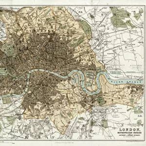
Postcard : Map of London


![]()
Cards from Universal Images Group (UIG)
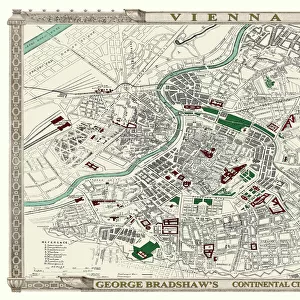
Map of London
Map of London 1836
Universal Images Group (UIG) manages distribution for many leading specialist agencies worldwide
Media ID 20165295
1830s Antiquarian Antiquarian Maps Geneology Journeys Travels Treks Trips Voyage
Postcards (8 pack of A6)
Set of 8, A6 Postcards, featuring the same image on all cards in a set. Printed on 350gsm premium white satin card, the back of the postcard includes space to write messages and an area for the address and stamp. Size of each postcard is 15cm x 10.6cm.
Photo postcards are a great way to stay in touch with family and friends.
Estimated Product Size is 15cm x 10.6cm (5.9" x 4.2")
These are individually made so all sizes are approximate
Artwork printed orientated as per the preview above, with landscape (horizontal) or portrait (vertical) orientation to match the source image.
FEATURES IN THESE COLLECTIONS
> Europe
> United Kingdom
> England
> Maps
> Maps and Charts
> Related Images
> Universal Images Group (UIG)
> History
> Historical Maps
EDITORS COMMENTS
This print showcases a remarkable piece of history - the "Map of London 1836". Dating back to the early 19th century, this antique map offers a fascinating glimpse into the past, taking us on a journey through time. With intricate details and exquisite craftsmanship, it serves as both an invaluable resource for genealogists and an enchanting visual representation of London's rich heritage. As we explore this vintage map, we are transported to a bygone era when horse-drawn carriages roamed the cobbled streets and towering landmarks dotted the cityscape. Every street corner, park, and river is meticulously depicted with utmost precision, allowing us to trace the footsteps of our ancestors or simply marvel at how much has changed over centuries. The Map of London 1836 not only serves as a testament to human ingenuity but also ignites our sense of adventure. It beckons us to embark on virtual voyages across neighborhoods long forgotten or rediscover familiar places in their former glory. Whether you're an avid traveler seeking inspiration for your next trip or an enthusiast delving into historical cartography, this print is sure to captivate your imagination. Thanks to PicturesNow UIG from Universal Images Group (UIG), this extraordinary piece can now be admired in all its splendor. So take a moment to immerse yourself in its beauty and let it transport you back in time - where old meets new and history comes alive before your eyes.
MADE IN THE UK
Safe Shipping with 30 Day Money Back Guarantee
FREE PERSONALISATION*
We are proud to offer a range of customisation features including Personalised Captions, Color Filters and Picture Zoom Tools
SECURE PAYMENTS
We happily accept a wide range of payment options so you can pay for the things you need in the way that is most convenient for you
* Options may vary by product and licensing agreement. Zoomed Pictures can be adjusted in the Basket.