Postcard > Arts > Artists > H > Hittite Hittite
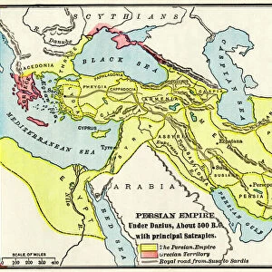
Postcard : Map of the Mideast in ancient times


![]()
Cards from North Wind
Map of the Mideast in ancient times
Map of the ancient Near East, birthplace of civilization.
Hand-colored woodcut of a 19th-century illustration
North Wind Picture Archives brings history to life with stock images and hand-colored illustrations
Media ID 5877997
© North Wind Picture Archives
Africa Ancient Ancient Civilization Ancient History Antiquity Arabia Asia Minor Babylon Babylonia Civilization Classical Classical Civilization Egypt Mediterranean Mediterranean Sea Mesopotamia Mid East Middle East North Africa Phoenicia Tyre Armenia Ethiopia Hittites Lydia Medea Nubia Red Sea
Postcards (8 pack of A6)
Set of 8, A6 Postcards, featuring the same image on all cards in a set. Printed on 350gsm premium white satin card, the back of the postcard includes space to write messages and an area for the address and stamp. Size of each postcard is 15cm x 10.6cm.
Photo postcards are a great way to stay in touch with family and friends.
Estimated Product Size is 10.6cm x 15cm (4.2" x 5.9")
These are individually made so all sizes are approximate
Artwork printed orientated as per the preview above, with landscape (horizontal) or portrait (vertical) orientation to match the source image.
FEATURES IN THESE COLLECTIONS
> North Wind Picture Archives
> Ancient history
> North Wind Picture Archives
> Maps
> Africa
> Egypt
> Related Images
> Africa
> Ethiopia (Abyssinia)
> Related Images
> Africa
> Ethiopia
> Related Images
> Africa
> Related Images
> Arts
> Artists
> H
> Hittite Hittite
> Asia
> Armenia
> Related Images
> Asia
> Related Images
EDITORS COMMENTS
This hand-colored woodcut print showcases a mesmerizing "Map of the Mideast in ancient times" offering a glimpse into the birthplace of civilization. Dating back to the 19th century, this vintage illustration takes us on an enchanting journey through history. The map encompasses various regions and civilizations that flourished during antiquity, such as Egypt, Phoenicia, Babylon, Lydia, Nubia, and many others. It highlights their interconnectedness and significance in shaping our understanding of ancient history. As we explore this intricate artwork, we are transported to a time when these lands were at the forefront of human progress and cultural development. The Mediterranean Sea acts as a central hub connecting different civilizations across Africa and Asia Minor. From majestic pyramids rising along the banks of the Nile River to bustling trade routes crisscrossing Arabia and Mesopotamia's fertile plains – every corner holds tales waiting to be discovered. This stunning piece not only celebrates classical civilization but also serves as a reminder of humanity's rich heritage rooted in these lands. It invites us to reflect upon our shared past while appreciating the diverse cultures that once thrived here. Whether you are an art enthusiast or history lover, this remarkable print is sure to captivate your imagination with its intricate details and vibrant colors. Let it transport you back in time as you delve into the wonders of ancient civilizations etched onto this timeless masterpiece.
MADE IN THE UK
Safe Shipping with 30 Day Money Back Guarantee
FREE PERSONALISATION*
We are proud to offer a range of customisation features including Personalised Captions, Color Filters and Picture Zoom Tools
SECURE PAYMENTS
We happily accept a wide range of payment options so you can pay for the things you need in the way that is most convenient for you
* Options may vary by product and licensing agreement. Zoomed Pictures can be adjusted in the Basket.