Postcard > Arts > Photorealistic artworks > Detailed art pieces > Masterful detailing in art
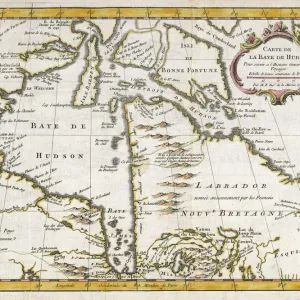
Postcard : Old Map of Northern India 1852 by Henry George Collins


![]()
Cards from MapSeeker
Old Map of Northern India 1852 by Henry George Collins
This is a finely detailed map of Northern India remastered from a rare Atlas of the World published in 1852 by Henry George Collins. Although these Henry Collins produced maps of the highest quality in his time unfortunately not the same could be said in terms of his business success. His maps were later obtained by the famous Stanford Map Company and used in their publications
Welcome to the Mapseeker Image library and enter an historic gateway to one of the largest on-line collections of Historic Maps, Nostalgic Views, Vista's and Panorama's from a World gone by.
Media ID 20347269
© Mapseeker Publishing Ltd
Collins Collins Atlas Collins Atlas Map Collins Map North India Northern India
Postcards (8 pack of A6)
Set of 8, A6 Postcards, featuring the same image on all cards in a set. Printed on 350gsm premium white satin card, the back of the postcard includes space to write messages and an area for the address and stamp. Size of each postcard is 15cm x 10.6cm.
Photo postcards are a great way to stay in touch with family and friends.
Estimated Product Size is 15cm x 10.6cm (5.9" x 4.2")
These are individually made so all sizes are approximate
Artwork printed orientated as per the preview above, with landscape (horizontal) or portrait (vertical) orientation to match the source image.
FEATURES IN THESE COLLECTIONS
> MapSeeker
> Maps of Asia and Middle East
> Maps of Countries in Asia PORTFOLIO
> Arts
> Photorealistic artworks
> Detailed art pieces
> Masterful detailing in art
> Asia
> India
> Related Images
> Maps and Charts
> India
> Maps and Charts
> Related Images
> Maps and Charts
> World
EDITORS COMMENTS
This beautifully preserved print showcases an Old Map of Northern India from 1852, meticulously crafted by the talented cartographer Henry George Collins. Remastered from a rare Atlas of the World published in that era, this map offers a fascinating glimpse into the geographical landscape and political boundaries of Northern India during that time. Henry Collins was renowned for his exceptional craftsmanship and attention to detail when it came to creating maps. His dedication to accuracy is evident in this piece, as every intricate feature is carefully depicted. From rivers and mountain ranges to cities and villages, this map provides an invaluable historical record of Northern India's geography. Despite his undeniable talent, Henry Collins did not achieve great success in terms of business ventures. However, fate smiled upon him when his remarkable maps caught the attention of the esteemed Stanford Map Company. Recognizing their value and quality, they acquired Collins' collection and incorporated them into their own publications. Nowadays, this remastered print serves as a testament to both Henry George Collins' skill as a cartographer and the enduring legacy of his work. It allows us to travel back in time and explore Northern India through the eyes of those who lived there over 150 years ago. A true treasure for history enthusiasts or anyone with an appreciation for fine craftsmanship.
MADE IN THE UK
Safe Shipping with 30 Day Money Back Guarantee
FREE PERSONALISATION*
We are proud to offer a range of customisation features including Personalised Captions, Color Filters and Picture Zoom Tools
SECURE PAYMENTS
We happily accept a wide range of payment options so you can pay for the things you need in the way that is most convenient for you
* Options may vary by product and licensing agreement. Zoomed Pictures can be adjusted in the Basket.