Fraud Blocker Skip to main content

Postcard > Europe > France > Paris > Maps

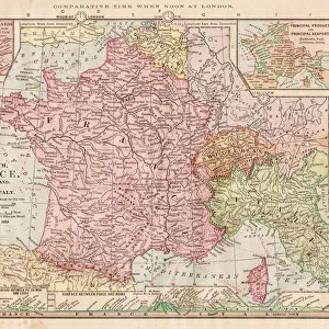
Postcard : Map of France 1896

Map of France 1896


-
+
£12.48

We accept all major credit cards


Photo Prints
Jigsaw Puzzles
Poster Prints
Canvas Prints
Fine Art Prints
Mounted Prints
Metal Prints
Cards
Home Decor


Fine Art Storehouse

Cards from Fine Art Storehouse

Map of France 1896

Andres Allgemeiner Handatlas - Bielefeld und Leipzig 1896

Unleash your creativity and transform your space into a visual masterpiece!

THEPALMER

Media ID 15133654

© This content is subject to copyright

Paris


Postcards (8 pack of A6)

Set of 8, A6 Postcards, featuring the same image on all cards in a set. Printed on 350gsm premium white satin card, the back of the postcard includes space to write messages and an area for the address and stamp. Size of each postcard is 15cm x 10.6cm.

Photo postcards are a great way to stay in touch with family and friends.

Estimated Product Size is 15cm x 10.6cm (5.9" x 4.2")

These are individually made so all sizes are approximate

Artwork printed orientated as per the preview above, with landscape (horizontal) or portrait (vertical) orientation to match the source image.


FEATURES IN THESE COLLECTIONS

> Fine Art Storehouse > Map > Historical Maps

> Fine Art Storehouse > Map

> Europe > France > Maps

> Europe > France > Paris > Maps

> Europe > France > Paris > Related Images

> Europe > Germany > Bielefeld

> Europe > Germany > Leipzig

> Europe > Germany > Maps

> Europe > Germany > Posters

> Europe > Germany > Related Images

> Europe > Related Images

> Maps and Charts > France


MADE IN THE UK
Safe Shipping with 30 Day Money Back Guarantee

FREE PERSONALISATION*
We are proud to offer a range of customisation features including Personalised Captions, Color Filters and Picture Zoom Tools

SECURE PAYMENTS
We happily accept a wide range of payment options so you can pay for the things you need in the way that is most convenient for you

* Options may vary by product and licensing agreement. Zoomed Pictures can be adjusted in the Basket.


globe_uk
Made in UK
thumb_up
Professional quality finish
diamond
Made with high-grade materials
inventory_2
Carefully packed to aid safe arrival


Related Images


MAP OF FRANCE, c1900. With inset detail of Paris and surrounding area
Cartoon map of Florida
Old Antique map of Egypt, detail of River Nile, Alexandria, Cairo, 1890s, Victorian 19th Century history
Map Europe European 1930's 20th Century Country
Africa map of 1869
Africa map of 1869
Antique map of France in Provinces, 1831
Antique Map of France - 19th Century
Map of Germany - Vector
Map of North and East sea 1896
Map of Great Britain and Ireland 1877
Map of France 1886
Map of France 1886
Antique map of France

+

Shipping

+

Choices

+

Reviews

+

Guaranteed


Related Collections


Map
Map
Browse 9,858 Prints
Europe Related Images
Browse 45,635 Prints
Germany Related Images
Browse 45,123 Prints
Leipzig
Leipzig
Browse 2,761 Prints
Bielefeld
Bielefeld
Browse 33 Prints
Maps
Maps
Browse 10,851 Prints
Maps
Maps
Browse 5,815 Prints
France
France
Browse 10,851 Prints
Paris Related Images
Browse 47,003 Prints
Maps
Maps
Browse 2,095 Prints
Posters
Posters
Browse 45,278 Prints
Historical Maps
Historical Maps
Browse 3,309 Prints