Postcard > Arts > Artists > R > Jacopo Russo
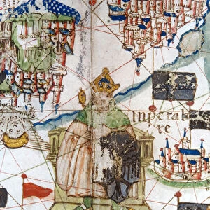
Postcard : Renaissance map of Europe, Jacopo Russo (after) 1528
 1528")
 1528")


![]()
Cards from Fine Art Finder
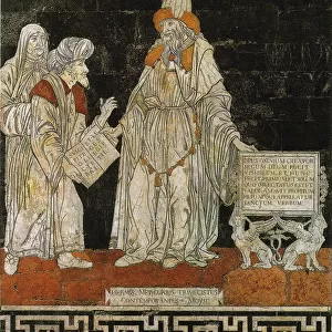
Renaissance map of Europe, Jacopo Russo (after) 1528
2910973 Renaissance map of Europe, Jacopo Russo (after) 1528 by Russo, Jacopo (15th century); (add.info.: Renaissance map of Europe, Jacopo Russo, 1528, detail, showing three sailing ships of 16th century.); Universal History Archive/UIG; Italian, out of copyright
Media ID 22717184
© Universal History Archive/UIG / Bridgeman Images
Postcards (8 pack of A6)
Set of 8, A6 Postcards, featuring the same image on all cards in a set. Printed on 350gsm premium white satin card, the back of the postcard includes space to write messages and an area for the address and stamp. Size of each postcard is 15cm x 10.6cm.
Photo postcards are a great way to stay in touch with family and friends.
Estimated Product Size is 15cm x 10.6cm (5.9" x 4.2")
These are individually made so all sizes are approximate
Artwork printed orientated as per the preview above, with landscape (horizontal) or portrait (vertical) orientation to match the source image.
FEATURES IN THESE COLLECTIONS
> Fine Art Finder
> Artists
> Jacopo Russo
> Fine Art Finder
> Artists
> Lewis Wickes Hine
> Fine Art Finder
> Maps (celestial & Terrestrial)
> Arts
> Art Movements
> Renaissance Art
> Arts
> Artists
> R
> Jacopo Russo
> Europe
> Italy
> Related Images
> Europe
> Related Images
> Historic
> Renaissance art
> Italian Renaissance art
> Maps and Charts
> Italy
EDITORS COMMENTS
This print showcases a Renaissance map of Europe, created by the talented Jacopo Russo in 1528. The intricate detail and artistry of this piece transport us back to the 16th century, allowing us to marvel at the advancements in cartography during the Renaissance period. The focal point of this image is three majestic sailing ships that dominate the scene. These vessels represent the maritime prowess and exploration spirit of that era. They serve as a reminder of Europe's rich history as a seafaring continent, with its navigators venturing into uncharted waters to discover new lands. As we delve deeper into this map, we are drawn to its meticulous depiction of geographical features. From mountain ranges and rivers to cities and coastlines, every element is intricately illustrated, showcasing Russo's attention to detail and commitment to accuracy. This particular print captures an essence of European identity during the Renaissance – a time when scientific discoveries were reshaping our understanding of geography and expanding horizons both literally and metaphorically. With its vibrant colors, historical significance, and undeniable beauty, this Renaissance map offers not only a glimpse into Europe's past but also serves as a testament to human curiosity and exploration. It reminds us that even centuries later, these maps continue to inspire awe for their artistic merit while providing valuable insights into our shared heritage.
MADE IN THE UK
Safe Shipping with 30 Day Money Back Guarantee
FREE PERSONALISATION*
We are proud to offer a range of customisation features including Personalised Captions, Color Filters and Picture Zoom Tools
SECURE PAYMENTS
We happily accept a wide range of payment options so you can pay for the things you need in the way that is most convenient for you
* Options may vary by product and licensing agreement. Zoomed Pictures can be adjusted in the Basket.