Postcard > Arts > Artists > P > Peruvian School Peruvian School
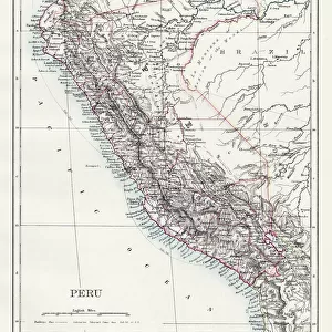
Postcard : Map of part of New Spain, the coast of Peru and the city of Lima


![]()
Cards from Fine Art Finder
Map of part of New Spain, the coast of Peru and the city of Lima
AIS5337946 Map of part of New Spain, the coast of Peru and the city of Lima, from " Mapas de las costas de America en el mar del Sur, desde la ltima poblaciAon de espaAnoles en ellas, que es la ciudad de Compostela, en adelante", 17th century (manuscript) by Spanish School, (17th century); 30 x 21 cm; Biblioteca Nacional, Madrid, Spain; (add.info.: Map of part of New Spain (New Spain) with the coasts of Peru and the city of Lima.
From " Mapas de las costas de America en el mar del Sur, desde la ltima poblaciAon de espaAnoles en ellas, que es la ciudad de Compostela, en adelante" (Ms. 2957. Sheet 95v. and 97.)
Madrid, National Library); eIberfoto; Spanish, out of copyright
Media ID 23342454
© Iberfoto / Bridgeman Images
Central America Lima Peru Peru Peruvian Peruvian Peruvians Geographical Map Latine America
Postcards (8 pack of A6)
Set of 8, A6 Postcards, featuring the same image on all cards in a set. Printed on 350gsm premium white satin card, the back of the postcard includes space to write messages and an area for the address and stamp. Size of each postcard is 15cm x 10.6cm.
Photo postcards are a great way to stay in touch with family and friends.
Estimated Product Size is 15cm x 10.6cm (5.9" x 4.2")
These are individually made so all sizes are approximate
Artwork printed orientated as per the preview above, with landscape (horizontal) or portrait (vertical) orientation to match the source image.
FEATURES IN THESE COLLECTIONS
> Fine Art Finder
> Artists
> Islamic School
> Fine Art Finder
> Artists
> Spanish School (after)
> Arts
> Artists
> P
> Peruvian School Peruvian School
> Arts
> Artists
> S
> Spanish School
> Europe
> Spain
> Related Images
> Maps and Charts
> Related Images
> Maps and Charts
> Spain
> South America
> Peru
> Lima
> South America
> Peru
> Maps
EDITORS COMMENTS
This 17th-century map print showcases a part of New Spain, the coast of Peru, and the magnificent city of Lima. Measuring 30 x 21 cm, this manuscript is housed in the Biblioteca Nacional in Madrid, Spain. The map provides a detailed depiction of New Spain with its sprawling coastline extending to Peru and highlighting the vibrant city of Lima. It offers a glimpse into the geographical landscape and cartography techniques used during that era. Originally featured in "Mapas de las costas de America en el mar del Sur" this particular section (Ms. 2957. Sheet 95v. and 97. ) captures the essence of Central America's maritime significance during colonial times. The Spanish School's craftsmanship shines through as they meticulously illustrate every coastal detail and geographic feature on this historic document. The intricate lines and careful shading bring to life an accurate representation of South America's western shores. As we explore this ancient artifact, it transports us back to a time when exploration was at its peak, showcasing how early navigators charted their way across uncharted territories. This remarkable piece serves as both an educational tool for understanding historical geography and as a testament to human curiosity about our world's vastness centuries ago. Its preservation allows us to appreciate not only the artistry but also gain insight into past civilizations' knowledge and aspirations for discovery.
MADE IN THE UK
Safe Shipping with 30 Day Money Back Guarantee
FREE PERSONALISATION*
We are proud to offer a range of customisation features including Personalised Captions, Color Filters and Picture Zoom Tools
SECURE PAYMENTS
We happily accept a wide range of payment options so you can pay for the things you need in the way that is most convenient for you
* Options may vary by product and licensing agreement. Zoomed Pictures can be adjusted in the Basket.