Postcard > Arts > Artists > L > Guillaume Le Testu
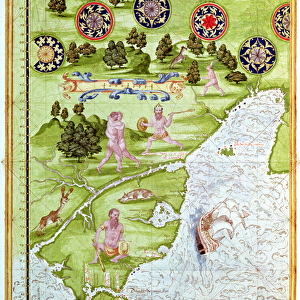
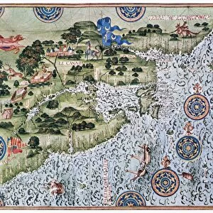
Postcard : Fol. 39v Map of the Magellan Straits, from Cosmographie Universelle, 1555


![]()
Cards from Fine Art Finder
Fol. 39v Map of the Magellan Straits, from Cosmographie Universelle, 1555
XIR161170 Fol.39v Map of the Magellan Straits, from Cosmographie Universelle, 1555 (w/c on paper) by Le Testu, Guillaume (c.1509-73); Min. Defense - Service Historique de l Armee de Terre, France; (add.info.: terre australe et detroit de Magellan; ); French, out of copyright
Media ID 12733992
© www.bridgemanimages.com
Compass Patagonia Savage Strait Tierra Del Fuego Cosmographie
Postcards (8 pack of A6)
Set of 8, A6 Postcards, featuring the same image on all cards in a set. Printed on 350gsm premium white satin card, the back of the postcard includes space to write messages and an area for the address and stamp. Size of each postcard is 15cm x 10.6cm.
Photo postcards are a great way to stay in touch with family and friends.
Estimated Product Size is 10.6cm x 15cm (4.2" x 5.9")
These are individually made so all sizes are approximate
Artwork printed orientated as per the preview above, with landscape (horizontal) or portrait (vertical) orientation to match the source image.
FEATURES IN THESE COLLECTIONS
> Fine Art Finder
> Artists
> Guillaume Le Testu
> Fine Art Finder
> Maps (celestial & Terrestrial)
> Arts
> Artists
> L
> Guillaume Le Testu
EDITORS COMMENTS
This print titled "Fol. 39v Map of the Magellan Straits, from Cosmographie Universelle, 1555" takes us back in time to explore the uncharted territories of Tierra del Fuego and Patagonia. Created by Guillaume Le Testu in the mid-16th century, this watercolor on paper masterpiece offers a glimpse into the early European understanding of South America's southernmost region. The map showcases not only geographical features but also provides insights into indigenous cultures and wildlife encountered during that era. The intricate details depict native inhabitants engaged in hunting activities while exotic birds soar above them. A ship sails through treacherous waters as it navigates the legendary Magellan Straits, an important passage connecting two oceans. Le Testu's work is a testament to his meticulousness as he includes compasses and other navigational tools within the map itself. This attention to detail highlights both his artistic skill and scientific knowledge prevalent during this period of exploration. As we gaze upon this historic print, we are transported to an age when much of our world remained unknown and untamed. It serves as a reminder of humanity's insatiable curiosity for discovery and our relentless pursuit to conquer new frontiers.
MADE IN THE UK
Safe Shipping with 30 Day Money Back Guarantee
FREE PERSONALISATION*
We are proud to offer a range of customisation features including Personalised Captions, Color Filters and Picture Zoom Tools
SECURE PAYMENTS
We happily accept a wide range of payment options so you can pay for the things you need in the way that is most convenient for you
* Options may vary by product and licensing agreement. Zoomed Pictures can be adjusted in the Basket.