Photographic Print > North America > Canada > Maps
Photographic Print : Quebec, 1870s

![]()
Photo Prints from North Wind
Quebec, 1870s
Map of Quebec province, Canada, 1870s.
Printed color lithograph
North Wind Picture Archives brings history to life with stock images and hand-colored illustrations
Media ID 5879745
© North Wind Picture Archives
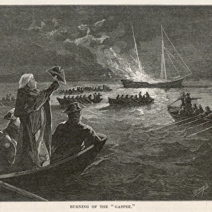
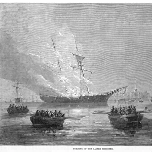
1870s Canada Canadian French Canada French Canadian Gaspee Quebec
12"x8" (30x20cm) Photo Print
Step back in time with our exquisite reproduction of a vintage lithograph from North Wind Picture Archives, depicting Quebec, Canada during the 1870s. This captivating photograph brings the history of the Quebec province to life with its rich, authentic details. The intricately mapped terrain, dotted with quaint villages and bustling towns, is a testament to the beauty and charm of the past. Bring this piece of history into your home or office and add a touch of timeless elegance to your decor. Order now and relive the past with our high-quality, museum-grade photographic prints.
Printed on archival quality paper for unrivalled stable artwork permanence and brilliant colour reproduction with accurate colour rendition and smooth tones. Printed on professional 234gsm Fujifilm Crystal Archive DP II paper. 12x8 for landscape images, 8x12 for portrait images.
Our Photo Prints are in a large range of sizes and are printed on Archival Quality Paper for excellent colour reproduction and longevity. They are ideal for framing (our Framed Prints use these) at a reasonable cost. Alternatives include cheaper Poster Prints and higher quality Fine Art Paper, the choice of which is largely dependant on your budget.
Estimated Product Size is 30.5cm x 20.3cm (12" x 8")
These are individually made so all sizes are approximate
Artwork printed orientated as per the preview above, with landscape (horizontal) orientation to match the source image.
FEATURES IN THESE COLLECTIONS
> North Wind Picture Archives
> Canadian history
> North Wind Picture Archives
> Maps
> Maps and Charts
> Related Images
> North America
> Canada
> Maps
> North America
> Canada
> Related Images
> North America
> Related Images
EDITORS COMMENTS
This vintage print takes us back to the 1870s, offering a glimpse into the rich history and heritage of Quebec province in Canada. The beautifully detailed map showcases the region's vast landscapes, towns, and rivers with intricate precision. Printed using lithograph techniques and adorned with vibrant colors, this artwork captures the essence of traditional cartography from a bygone era. The illustration transports us to a time when French Canadian culture thrived in Quebec. As we explore the map, we can imagine the bustling streets of historic cities like Montreal and Quebec City, where echoes of centuries-old architecture still stand today. The Gaspee Peninsula stands out prominently on this map as well – an area known for its natural beauty and historical significance. Beyond its aesthetic appeal, this piece serves as a valuable historical artifact that sheds light on Canada's past. It reminds us of how borders have evolved over time and offers insight into North America's changing landscape during the late 19th century. North Wind Picture Archives has expertly preserved this piece of artistry for future generations to appreciate. Whether you are an art enthusiast or a history buff, this print is sure to transport you back in time while celebrating the enduring legacy of French Canada in all its glory.
MADE IN THE UK
Safe Shipping with 30 Day Money Back Guarantee
FREE PERSONALISATION*
We are proud to offer a range of customisation features including Personalised Captions, Color Filters and Picture Zoom Tools
SECURE PAYMENTS
We happily accept a wide range of payment options so you can pay for the things you need in the way that is most convenient for you
* Options may vary by product and licensing agreement. Zoomed Pictures can be adjusted in the Basket.