Photographic Print > Arts > Artists > E > David Evans
Photographic Print : Trench maps belonging to Sergeant Ernest Blaikley


![]()
Photo Prints from Mary Evans Picture Library
Trench maps belonging to Sergeant Ernest Blaikley
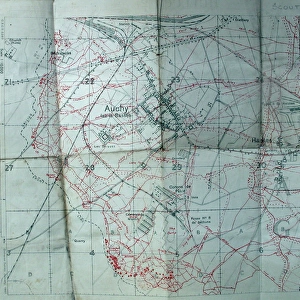
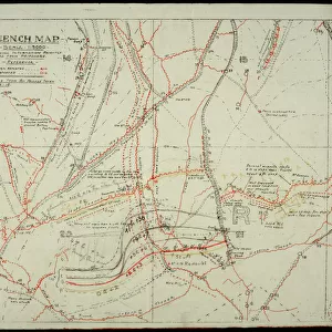
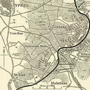
Trench maps belonging to 2903 Sergeant ERNEST BLAIKLEY, 28th Battalion London Regiment (Artists Rifles) (1885-1965). Attached S.O. & S. School (Sniping, Observation and Scouting School) at Linghem, Hesdin and Senlis.1. Trench map of France, Sheet 51C, 1/40, 000, First Edition (Arras/Albert). 2. Trench maps, 36 NE and 36a SW. 3. Trench map - 1/10, 000 dated January 1917 (Auchy-la-Bass饬 Hulluch). 4. Plan de la ville, Arras. Collection
Mary Evans Picture Library makes available wonderful images created for people to enjoy over the centuries
Media ID 14150641
© David Cohen Fine Art/Mary Evans Picture Library
10000 1885 1965 28th 2903 40000 Arras Attached Auchy Bass Bassae Battalion Belonging Dated Edition Ernest First Hesdin Hulluch Maps Observation Plan Regiment Rifles Sergeant Sheet Sniping Trench Ville Albert Blaikley January Scouting
10"x8" (25x20cm) Photo Print
Discover the historical depth of our Media Storehouse Photographic Prints collection with this captivating image of trench maps belonging to Sergeant Ernest Blaikley. These authentic World War I documents offer a glimpse into the past, providing a poignant reminder of the sacrifices made during this pivotal time in history. Sergeant Blaikley served with the 28th Battalion London Regiment (Artists Rifles), and these trench maps were an essential tool in his role as a Sergeant-in-Charge of a section during the conflict. The intricate details and annotations on the maps tell a story of strategy, planning, and survival. Our high-quality prints bring the history to life, allowing you to display this unique piece of military heritage in your home or office. Each print is produced using archival-quality materials to ensure the long-lasting beauty and authenticity of the image. Rights Managed through Mary Evans Prints Online, these prints are perfect for history enthusiasts, military collectors, or anyone looking to add a touch of historical significance to their space. Bring the past into the present with this exclusive Media Storehouse Photographic Print.
Printed on archival quality paper for unrivalled stable artwork permanence and brilliant colour reproduction with accurate colour rendition and smooth tones. Printed on professional 234gsm Fujifilm Crystal Archive DP II paper. 10x8 for landscape images, 8x10 for portrait images.
Our Photo Prints are in a large range of sizes and are printed on Archival Quality Paper for excellent colour reproduction and longevity. They are ideal for framing (our Framed Prints use these) at a reasonable cost. Alternatives include cheaper Poster Prints and higher quality Fine Art Paper, the choice of which is largely dependant on your budget.
Estimated Product Size is 25.4cm x 20.3cm (10" x 8")
These are individually made so all sizes are approximate
Artwork printed orientated as per the preview above, with landscape (horizontal) orientation to match the source image.
EDITORS COMMENTS
This collection of trench maps belonged to 2903 Sergeant Ernest Blaikley of the 28th Battalion London Regiment (Artists Rifles). Ernest served as an Attached Staff Officer and Instructor at the Sniping, Observation and Scouting School in Linghem, Hesdin, and Senlis during World War I. The maps provide insight into the complex network of trenches and fortifications in the Arras and Albert regions of France. The first map, Sheet 51C, 1/40,000, First Edition, covers the Arras and Albert area, providing a comprehensive overview of the battlefield. The second pair of maps, 36 NE and 36a SW, offer more detailed views of specific areas, likely used for targeted reconnaissance and planning. The final map, 1/10,000, dated January 1917, focuses on the area around Auchy-la-Bassée and Hulluch, providing a precise and up-to-date representation of the battlefield at a critical time in the war. The Plan de la ville, Arras, further illustrates the importance of detailed mapping during this period. These maps would have been essential tools for Ernest and his students as they honed their skills in sniping, observation, and scouting, contributing to the Allied war effort in the trenches of France.
MADE IN THE UK
Safe Shipping with 30 Day Money Back Guarantee
FREE PERSONALISATION*
We are proud to offer a range of customisation features including Personalised Captions, Color Filters and Picture Zoom Tools
SECURE PAYMENTS
We happily accept a wide range of payment options so you can pay for the things you need in the way that is most convenient for you
* Options may vary by product and licensing agreement. Zoomed Pictures can be adjusted in the Basket.