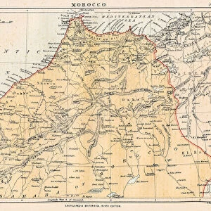
Photographic Print > Africa > Egypt > Maps
Photographic Print : MAP / AFRICA / EGYPT / COAST


![]()
Photo Prints from Mary Evans Picture Library
MAP / AFRICA / EGYPT / COAST
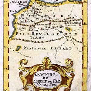
Map of Egypt: the coastline near Alexandria, at the time of the Battle of the Nile (1 August 1798) Date: 1798
Mary Evans Picture Library makes available wonderful images created for people to enjoy over the centuries
Media ID 20155191
© Bubblepunk
1798 Alexandria Coastline Maps Nile
10"x8" (25x20cm) Photo Print
Discover the rich history and beauty of Egypt with our exquisite Media Storehouse Photographic Prints. This captivating image depicts an intricately detailed map of Egypt from 1798, focusing on the coastline near Alexandria. Witness the strategic location of this area during the historic Battle of the Nile. Bring a piece of ancient history into your home or office with our high-quality, museum-grade prints. Perfect for history enthusiasts, educators, or anyone with a passion for the wonders of Egypt.
Printed on archival quality paper for unrivalled stable artwork permanence and brilliant colour reproduction with accurate colour rendition and smooth tones. Printed on professional 234gsm Fujifilm Crystal Archive DP II paper. 10x8 for landscape images, 8x10 for portrait images.
Our Photo Prints are in a large range of sizes and are printed on Archival Quality Paper for excellent colour reproduction and longevity. They are ideal for framing (our Framed Prints use these) at a reasonable cost. Alternatives include cheaper Poster Prints and higher quality Fine Art Paper, the choice of which is largely dependant on your budget.
Estimated Product Size is 25.4cm x 20.3cm (10" x 8")
These are individually made so all sizes are approximate
Artwork printed orientated as per the preview above, with landscape (horizontal) orientation to match the source image.
FEATURES IN THESE COLLECTIONS
> Mary Evans Prints Online
> Egypt
> Mary Evans Prints Online
> New Images July 2020
> Africa
> Egypt
> Alexandria
> Africa
> Egypt
> Related Images
> Africa
> Related Images
> Historic
> Battles
> Related Images
> Maps and Charts
> Related Images
EDITORS COMMENTS
This map print depicts the coastline of Egypt, specifically the area around Alexandria, during the historic time of the Battle of the Nile on August 1, 1798. The map, dated 1798, provides a detailed view of the Egyptian coast, with the delta region and the Nile River prominently featured. The Battle of the Nile was a pivotal moment in the Napoleonic Wars, as it marked the decisive defeat of the French Navy under the command of Napoleon Bonaparte by the British Royal Navy, under Admiral Horatio Nelson. This naval battle took place in the waters off the Egyptian coast, preventing the French troops from reinforcing their army in Egypt and ultimately leading to the withdrawal of the French forces from the region. The map serves as a fascinating historical artifact, offering a glimpse into the geography of the region during a time of great significance in world history. The intricate details of the map, from the labeled towns and landmarks to the precise depiction of the coastline, make it an essential resource for scholars, historians, and anyone with an interest in the history of Egypt and the wider world.
MADE IN THE UK
Safe Shipping with 30 Day Money Back Guarantee
FREE PERSONALISATION*
We are proud to offer a range of customisation features including Personalised Captions, Color Filters and Picture Zoom Tools
SECURE PAYMENTS
We happily accept a wide range of payment options so you can pay for the things you need in the way that is most convenient for you
* Options may vary by product and licensing agreement. Zoomed Pictures can be adjusted in the Basket.