Photographic Print > Animals > Mammals > Cricetidae > Meridionalis
Photographic Print : Map Comitatus Artesiae et Flandriae Meridionalis et regionum circumj


![]()
Photo Prints from Liszt Collection
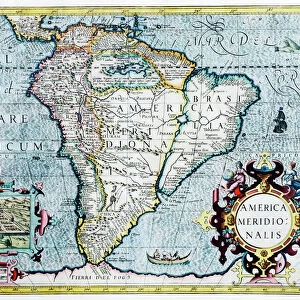
Map Comitatus Artesiae et Flandriae Meridionalis et regionum circumj
Map, Comitatus Artesiae et Flandriae Meridionalis et regionum circumjacentium nova descriptio =, Guillaume Delisle (1675-1726), Copperplate print
Liszt Collection of nineteenth-century engravings and images to browse and enjoy
Media ID 19586311
© Artokoloro
1675 1726 Copperplate Print Guillaume Delisle
10"x8" (25x20cm) Photo Print
Discover the rich history and intricate details of the Comitatus Artesiae et Flandriae Meridionalis et regionum circumjacentium nova descriptio map, a stunning masterpiece from the Liszt Collection. This exquisite copperplate print by Guillaume Delisle, created in 1675, showcases the Comté d'Artois and the Southern Netherlands, including modern-day Belgium and northern France. The intricate cartography and meticulous attention to detail make this print a must-have for history enthusiasts, geography aficionados, and art collectors alike. Bring a piece of the past into your home or office with the Media Storehouse range of Photographic Prints, expertly reproduced for the highest quality and vibrant color representation.
Printed on archival quality paper for unrivalled stable artwork permanence and brilliant colour reproduction with accurate colour rendition and smooth tones. Printed on professional 234gsm Fujifilm Crystal Archive DP II paper. 10x8 for landscape images, 8x10 for portrait images.
Our Photo Prints are in a large range of sizes and are printed on Archival Quality Paper for excellent colour reproduction and longevity. They are ideal for framing (our Framed Prints use these) at a reasonable cost. Alternatives include cheaper Poster Prints and higher quality Fine Art Paper, the choice of which is largely dependant on your budget.
Estimated Product Size is 25.4cm x 20.3cm (10" x 8")
These are individually made so all sizes are approximate
Artwork printed orientated as per the preview above, with landscape (horizontal) orientation to match the source image.
FEATURES IN THESE COLLECTIONS
> Animals
> Mammals
> Cricetidae
> Meridionalis
> Animals
> Mammals
> Sciuridae
> Meridionalis
> Maps and Charts
> Related Images
EDITORS COMMENTS
This copperplate print, titled "Map Comitatus Artesiae et Flandriae Meridionalis et regionum circumjacentium nova descriptio" is a masterpiece by the renowned cartographer Guillaume Delisle (1675-1726). Delisle's meticulous attention to detail and precision in his maps are evident in this stunning piece. The map showcases the southern regions of Artois and Flanders, along with their surrounding areas. Every line and contour on this print has been carefully engraved onto the copperplate, resulting in an intricate depiction of the landscape. From rivers snaking through towns to mountains rising majestically in the distance, every feature is captured with remarkable accuracy. Delisle's expertise shines through as he presents not only geographical information but also historical context. The names of cities, villages, and landmarks are meticulously labeled, providing invaluable insights into the cultural heritage of these regions during that era. As we gaze upon this exquisite work of art from Liszt Collection, we can't help but be transported back in time. It serves as a window into history—a testament to Delisle's mastery and dedication to his craft. This print would make a perfect addition for any enthusiast or collector who appreciates both beauty and historical significance
MADE IN THE UK
Safe Shipping with 30 Day Money Back Guarantee
FREE PERSONALISATION*
We are proud to offer a range of customisation features including Personalised Captions, Color Filters and Picture Zoom Tools
SECURE PAYMENTS
We happily accept a wide range of payment options so you can pay for the things you need in the way that is most convenient for you
* Options may vary by product and licensing agreement. Zoomed Pictures can be adjusted in the Basket.