Photographic Print > Arts > Artists > S > Syrian Syrian
Photographic Print : Pre-Persian, circa 600 B. C. c1915. Creator: Emery Walker Ltd

![]()
Photo Prints from Heritage Images
Pre-Persian, circa 600 B. C. c1915. Creator: Emery Walker Ltd
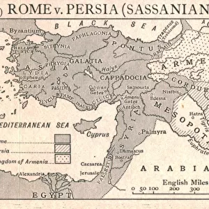
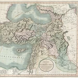
Pre-Persian, circa 600 B.C. c1915. Map of the eastern Mediterranean and near East, showing the ancient civilisations of empires of Lydia, Media, Babylonia, Independent States, and free Greek cities. From " The Caliphs Last Heritage, a short history of the Turkish Empire" by Lt.-Col. Sir Mark Sykes. [Macmillan & Co, London, 1915]
Heritage Images features heritage image collections
Media ID 19658843
© The Print Collector/Heritage Images
6th Baronet 6th Century Bc 7th Century Bc Anatolia Ancient World Armenia Armenian Babylonia Boutall Boutall Walker Cappadocia Cockerell Cockerell Walker Colonel Sir Tatton Benvenuto Mark Sykes Emery Emery Walker Limited Emery Walker Ltd Euphrates Lieutenant Colonel Sir Mark Sykes Macmillan Macmillan And Co Macmillan Publishers Macmillan Publishers Ltd Mark Mark Sykes Mediterranean Sea Mesopotamia Nile Nile Delta Phrygia Publishers Macmillan River Euphrates River Nile River Tigris Sir Mark Sykes Sykes Sykes Mark Sykes Mark Sir Sykes Tatton Benvenuto Mark Syria Tatton Benvenuto Mark Tatton Benvenuto Mark Sykes The Nile Thrace Tigris Tigris River Turkey Turkish Walker Walker Amp Walker And Boutall Walker And Cockerell Walker Boutall Walker Cockerell Walker Emery Ltd Mizraim
12"x8" (30x20cm) Photo Print
Step back in time with our exquisite Media Storehouse Photographic Prints, featuring the captivating work of Emery Walker Ltd. This particular print showcases a map of the Eastern Mediterranean and Near East, circa 600 B.C., offering a glimpse into the ancient civilizations of Lydia, Media, Babylonia, Independent States, and free Greek cities. Transport yourself to a world of rich history and culture with this stunning, vintage representation. Perfect for adding an air of antiquity to your home or office decor.
Printed on archival quality paper for unrivalled stable artwork permanence and brilliant colour reproduction with accurate colour rendition and smooth tones. Printed on professional 234gsm Fujifilm Crystal Archive DP II paper. 12x8 for landscape images, 8x12 for portrait images.
Our Photo Prints are in a large range of sizes and are printed on Archival Quality Paper for excellent colour reproduction and longevity. They are ideal for framing (our Framed Prints use these) at a reasonable cost. Alternatives include cheaper Poster Prints and higher quality Fine Art Paper, the choice of which is largely dependant on your budget.
Estimated Image Size (if not cropped) is 30.4cm x 18.7cm (12" x 7.4")
Estimated Product Size is 30.5cm x 20.3cm (12" x 8")
These are individually made so all sizes are approximate
Artwork printed orientated as per the preview above, with landscape (horizontal) orientation to match the source image.
FEATURES IN THESE COLLECTIONS
> Africa
> Egypt
> Related Images
> Arts
> Artists
> S
> Syrian Syrian
> Arts
> Landscape paintings
> Waterfall and river artworks
> River artworks
> Asia
> Armenia
> Related Images
> Asia
> Related Images
> Asia
> Syria
> Related Images
> Asia
> Turkey
> Related Images
EDITORS COMMENTS
This photo print, titled "Pre-Persian, circa 600 B. C. c1915" takes us back in time to the ancient civilizations of the eastern Mediterranean and near East. Created by Emery Walker Ltd in 1915, this map beautifully illustrates the empires of Lydia, Media, Babylonia, as well as independent states and free Greek cities. The intricate details showcased on this print provide a glimpse into the rich history of this region during the 6th and 7th centuries BC. From Anatolia to Egypt, from Armenia to Phrygia, every geographical feature is meticulously depicted with utmost precision. Lt. -Col. Sir Mark Sykes' book "The Caliphs Last Heritage: A Short History of the Turkish Empire" serves as a valuable reference for understanding these ancient civilizations that once thrived along the Nile Delta and Euphrates River. Emery Walker Limited's expertise shines through in their masterful creation of this historical map. The black-and-white aesthetic adds an air of sophistication while allowing viewers to focus on each country's location and its relationship with neighboring regions. As we gaze upon this remarkable piece of artistry from over a century ago, we are transported back to a time when empires rose and fell across these lands. It serves as a reminder that our present-day world is built upon the foundations laid by those who came before us - their stories etched into every contour and riverbed captured within this timeless image.
MADE IN THE UK
Safe Shipping with 30 Day Money Back Guarantee
FREE PERSONALISATION*
We are proud to offer a range of customisation features including Personalised Captions, Color Filters and Picture Zoom Tools
SECURE PAYMENTS
We happily accept a wide range of payment options so you can pay for the things you need in the way that is most convenient for you
* Options may vary by product and licensing agreement. Zoomed Pictures can be adjusted in the Basket.