Photographic Print > North America > Jamaica > Maps
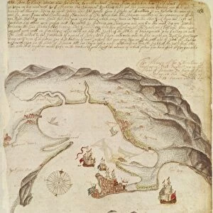
Photographic Print : MAP: JAMAICA, 1755. French map of Port Royal in Jamaica by Georges Louis Le Rouge, 1755

![]()
Photo Prints from Granger
MAP: JAMAICA, 1755. French map of Port Royal in Jamaica by Georges Louis Le Rouge, 1755
MAP: JAMAICA, 1755.
French map of Port Royal in Jamaica by Georges Louis Le Rouge, 1755
Granger holds millions of images spanning more than 25,000 years of world history, from before the Stone Age to the dawn of the Space Age
Media ID 12321394
1755 Island Jamaica Port Royal
12"x8" (30x20cm) Photo Print
Step back in time with our exquisite selection of antique maps from Granger, NYC's Media Storehouse. This captivating print showcases a rare 1755 French map of Port Royal in Jamaica by Georges Louis Le Rouge. Delve into the rich history of the Caribbean as you explore the intricate details of this beautifully preserved map. With its vibrant colors and intricate cartography, this print is not just a work of art, but a window into the past. Bring history into your home or office with this unique and intriguing piece from Granger Art on Demand.
Printed on archival quality paper for unrivalled stable artwork permanence and brilliant colour reproduction with accurate colour rendition and smooth tones. Printed on professional 234gsm Fujifilm Crystal Archive DP II paper. 12x8 for landscape images, 8x12 for portrait images.
Our Photo Prints are in a large range of sizes and are printed on Archival Quality Paper for excellent colour reproduction and longevity. They are ideal for framing (our Framed Prints use these) at a reasonable cost. Alternatives include cheaper Poster Prints and higher quality Fine Art Paper, the choice of which is largely dependant on your budget.
Estimated Product Size is 20.3cm x 30.5cm (8" x 12")
These are individually made so all sizes are approximate
Artwork printed orientated as per the preview above, with portrait (vertical) orientation to match the source image.
FEATURES IN THESE COLLECTIONS
> Granger Art on Demand
> Maps
> Maps and Charts
> Related Images
> North America
> Jamaica
> Maps
> North America
> Jamaica
> Related Images
EDITORS COMMENTS
This print takes us back in time to the year 1755, showcasing a meticulously detailed French map of Port Royal in Jamaica. Created by the talented cartographer Georges Louis Le Rouge, this historical artifact offers a fascinating glimpse into the past. The sepia tones add an air of nostalgia, enhancing our appreciation for the rich history embedded within this piece. The map itself is a testament to Le Rouge's skill and precision. Every street, building, and landmark is intricately depicted, allowing us to explore the layout of Port Royal as it stood centuries ago. From Fort Charles standing tall on its island perch to the surrounding coastline that hugs this bustling Jamaican town - every detail has been thoughtfully captured. As we delve deeper into this remarkable artwork, we are transported to an era where ships sailed across vast oceans and trade routes connected distant lands. The text accompanying the map provides valuable insights into its significance while adding another layer of authenticity. Granger Art on Demand has once again curated a masterpiece that not only showcases their expertise but also invites us to immerse ourselves in history. This print serves as a visual reminder of how far we have come and encourages us to appreciate both our present surroundings and those who came before us.
MADE IN THE UK
Safe Shipping with 30 Day Money Back Guarantee
FREE PERSONALISATION*
We are proud to offer a range of customisation features including Personalised Captions, Color Filters and Picture Zoom Tools
SECURE PAYMENTS
We happily accept a wide range of payment options so you can pay for the things you need in the way that is most convenient for you
* Options may vary by product and licensing agreement. Zoomed Pictures can be adjusted in the Basket.