Photographic Print > Fine Art Storehouse > Map
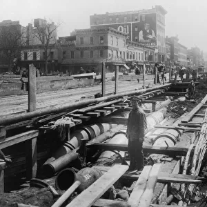
Photographic Print : City railways map 1895


![]()
Photo Prints from Fine Art Storehouse
City railways map 1895
Meyers Konversations-Lexikon. Ein Nachschlagewerk des allgemeinen Wissens, 5th edition 17 volumes Bibliographisches Institut - Leipzig 1895-1897
Unleash your creativity and transform your space into a visual masterpiece!
THEPALMER
Media ID 13609301
© This content is subject to copyright
Berlin London London England New York New York State Rail Transportation Railroad Track Railways Subway Vienna Vienna Austria Metro
10"x8" (25x20cm) Photo Print
Step back in time with our exquisite City Railways Map 1895 print from THEPALMER's collection at Media Storehouse. This captivating piece is taken from the fifth edition of Meyers Konversations-Lexikon, published by Bibliographisches Institut in Leipzig between 1895 and 1897. Delve into the rich history of urban transportation as you admire the intricate details of the city's railways system from over a century ago. Bring a piece of historical accuracy and charm to your home or office with this stunning fine art print.
Printed on archival quality paper for unrivalled stable artwork permanence and brilliant colour reproduction with accurate colour rendition and smooth tones. Printed on professional 234gsm Fujifilm Crystal Archive DP II paper. 10x8 for landscape images, 8x10 for portrait images.
Our Photo Prints are in a large range of sizes and are printed on Archival Quality Paper for excellent colour reproduction and longevity. They are ideal for framing (our Framed Prints use these) at a reasonable cost. Alternatives include cheaper Poster Prints and higher quality Fine Art Paper, the choice of which is largely dependant on your budget.
Estimated Product Size is 25.4cm x 20.3cm (10" x 8")
These are individually made so all sizes are approximate
Artwork printed orientated as per the preview above, with landscape (horizontal) orientation to match the source image.
FEATURES IN THESE COLLECTIONS
> Fine Art Storehouse
> Map
> Historical Maps
> Fine Art Storehouse
> Photo Libraries
> The Illustrated London News (ILN)
EDITORS COMMENTS
Discover the intricate web of city railways from a bygone era with this photo print. Taken from the pages of Meyers Konversations-Lexikon's 5th edition, published in Leipzig between 1895 and 1897, this vintage map offers a fascinating glimpse into the world's major metropolises at the turn of the century. Feast your eyes upon Berlin, London, New York City, and Vienna as their railway networks sprawl across the page in meticulous detail. Every railroad track is meticulously engraved and etched onto this antique illustration, showcasing not only the physical geography but also highlighting each city's unique transportation infrastructure. Transport yourself back to a time when subways were still a novelty and rail transportation was at its peak. Marvel at how these cities have evolved over time while tracing their historical roots through this stunning cartographic masterpiece. The fine craftsmanship of this print brings out every minute detail - from the delicate lines representing subway routes to the elegant typography that labels each station. Whether you're an avid collector or simply appreciate artful depictions of urban history, this print is sure to captivate your imagination. Add a touch of nostalgia to your home or office decor with 'City Railways Map 1895. ' Let it transport you back in time as you explore these iconic cities through their historic railway systems.
MADE IN THE UK
Safe Shipping with 30 Day Money Back Guarantee
FREE PERSONALISATION*
We are proud to offer a range of customisation features including Personalised Captions, Color Filters and Picture Zoom Tools
SECURE PAYMENTS
We happily accept a wide range of payment options so you can pay for the things you need in the way that is most convenient for you
* Options may vary by product and licensing agreement. Zoomed Pictures can be adjusted in the Basket.