Photographic Print > North America > United States of America > New York > New York > Maps
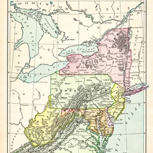
Photographic Print : Map Middle atlantic states 1877


![]()
Photo Prints from Fine Art Storehouse
Map Middle atlantic states 1877
Warrens Common School Geography 1877
Unleash your creativity and transform your space into a visual masterpiece!
THEPALMER
Media ID 14824581
© This content is subject to copyright
New Jersey New York Ohio Pennsylvania Virginia West Virginia
10"x8" (25x20cm) Photo Print
Step back in time with our vintage Map Middle Atlantic States 1877 print from THEPALMER at Fine Art Storehouse. This exquisite photographic print, taken from the Warrens Common School Geography 1877 textbook, offers a captivating glimpse into the past. The intricate details of the map showcase the geography of the Middle Atlantic States as it was depicted over a century ago. Add an air of history and character to your home or office with this unique and authentic piece of fine art. Order now and travel back in time with every glance.
Printed on archival quality paper for unrivalled stable artwork permanence and brilliant colour reproduction with accurate colour rendition and smooth tones. Printed on professional 234gsm Fujifilm Crystal Archive DP II paper. 10x8 for landscape images, 8x10 for portrait images.
Our Photo Prints are in a large range of sizes and are printed on Archival Quality Paper for excellent colour reproduction and longevity. They are ideal for framing (our Framed Prints use these) at a reasonable cost. Alternatives include cheaper Poster Prints and higher quality Fine Art Paper, the choice of which is largely dependant on your budget.
Estimated Product Size is 20.3cm x 25.4cm (8" x 10")
These are individually made so all sizes are approximate
Artwork printed orientated as per the preview above, with portrait (vertical) orientation to match the source image.
FEATURES IN THESE COLLECTIONS
> Fine Art Storehouse
> Map
> Historical Maps
> Fine Art Storehouse
> Map
> USA Maps
> Maps and Charts
> Related Images
> North America
> United States of America
> Maps
> North America
> United States of America
> New Jersey
> Related Images
> North America
> United States of America
> New York
> New York
> Maps
> North America
> United States of America
> New York
> Related Images
> North America
> United States of America
> Ohio
> Related Images
> North America
> United States of America
> Pennsylvania
> Related Images
> North America
> United States of America
> Virginia
> Related Images
> North America
> United States of America
> West Virginia
> Related Images
EDITORS COMMENTS
In this print titled "Map Middle Atlantic States 1877" we are transported back in time to the late 19th century, where cartography was an art form and exploration of new territories was still ongoing. This particular map, sourced from Warrens Common School Geography published in 1877, offers a fascinating glimpse into the geographical landscape of the Middle Atlantic states. The intricate details and vibrant colors of this vintage map draw us closer, inviting us to explore its rich history. From New Jersey to New York, Ohio to Pennsylvania, Virginia to West Virginia, each state is meticulously outlined with precision and care. The names of cities and towns dot the landscape like hidden treasures waiting to be discovered. As we examine this piece closely, it becomes apparent that it not only serves as a visual representation but also as a historical document capturing a specific moment in time. It reminds us of an era when these states were rapidly developing and shaping their identities amidst industrialization and westward expansion. "The Map Middle Atlantic States 1877" by THEPALMER showcases both artistic craftsmanship and educational significance. Its presence on display at Fine Art Storehouse allows viewers to appreciate the beauty inherent in maps while contemplating how our world has evolved over centuries. This print stands as a testament to human curiosity about our surroundings—a timeless reminder that even in today's digital age, there is something enchanting about holding a physical representation of our past within our hands.
MADE IN THE UK
Safe Shipping with 30 Day Money Back Guarantee
FREE PERSONALISATION*
We are proud to offer a range of customisation features including Personalised Captions, Color Filters and Picture Zoom Tools
SECURE PAYMENTS
We happily accept a wide range of payment options so you can pay for the things you need in the way that is most convenient for you
* Options may vary by product and licensing agreement. Zoomed Pictures can be adjusted in the Basket.