Photographic Print > Arts > Landscape paintings > Waterfall and river artworks > River artworks
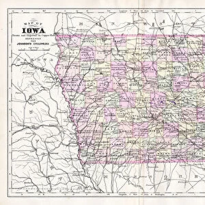
Photographic Print : Iowa 1852 Map


![]()
Photo Prints from Fine Art Storehouse
Iowa 1852 Map
Unleash your creativity and transform your space into a visual masterpiece!
benoitb
Media ID 13666899
© benoitb
Color Swatch Geographic Map Iowa Line Art Sketch State The Americas Us State Border Classical Style Drawing Art Product Painted Image Retro Styled Victorian Style
10"x8" (25x20cm) Photo Print
Printed on archival quality paper for unrivalled stable artwork permanence and brilliant colour reproduction with accurate colour rendition and smooth tones. Printed on professional 234gsm Fujifilm Crystal Archive DP II paper. 10x8 for landscape images, 8x10 for portrait images.
Our Photo Prints are in a large range of sizes and are printed on Archival Quality Paper for excellent colour reproduction and longevity. They are ideal for framing (our Framed Prints use these) at a reasonable cost. Alternatives include cheaper Poster Prints and higher quality Fine Art Paper, the choice of which is largely dependant on your budget.
Estimated Image Size (if not cropped) is 25.4cm x 18.2cm (10" x 7.2")
Estimated Product Size is 25.4cm x 20.3cm (10" x 8")
These are individually made so all sizes are approximate
Artwork printed orientated as per the preview above, with landscape (horizontal) orientation to match the source image.
FEATURES IN THESE COLLECTIONS
> Fine Art Storehouse
> Map
> Historical Maps
> Fine Art Storehouse
> Map
> USA Maps
> Arts
> Landscape paintings
> Waterfall and river artworks
> River artworks
> Maps and Charts
> Related Images
> North America
> United States of America
> Iowa
> Related Images
> North America
> United States of America
> Lakes
> Related Images
> North America
> United States of America
> Maps
EDITORS COMMENTS
This print showcases the Iowa 1852 Map, a stunning piece of cartography that takes us back to the 19th century. With its retro style and intricate details, this painted image resembles a sketch or line art drawing. The antique and engraved quality of the illustration adds an air of nostalgia and historical significance. The color swatches beautifully highlight the physical geography of Iowa, featuring lakes, rivers, and state borders in vibrant hues. This print is a true work of art that captures the essence of Victorian and classical styles. As we gaze upon this piece, we are transported to a bygone era when maps were meticulously crafted by hand. It serves as a reminder of our rich history and offers insight into how our understanding of geography has evolved over time. Benoitb's expertise shines through in every stroke, creating an enchanting visual representation of Iowa's landscape. Whether you're an avid collector or simply appreciate fine craftsmanship, this print is sure to be a cherished addition to any art collection.
MADE IN THE UK
Safe Shipping with 30 Day Money Back Guarantee
FREE PERSONALISATION*
We are proud to offer a range of customisation features including Personalised Captions, Color Filters and Picture Zoom Tools
SECURE PAYMENTS
We happily accept a wide range of payment options so you can pay for the things you need in the way that is most convenient for you
* Options may vary by product and licensing agreement. Zoomed Pictures can be adjusted in the Basket.