Photographic Print > Asia > Lebanon > Maps
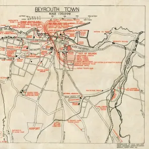
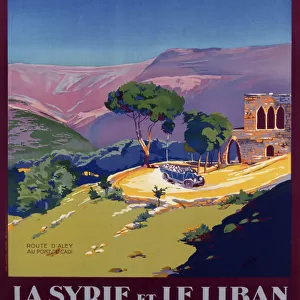
Photographic Print : Lebanon country map


Resolution may be poor at this size (92 DPI)
![]()
Photo Prints from Fine Art Storehouse
Lebanon country map
2011 edition
Unleash your creativity and transform your space into a visual masterpiece!
Media ID 14432087
10"x8" (25x20cm) Photo Print
Printed on archival quality paper for unrivalled stable artwork permanence and brilliant colour reproduction with accurate colour rendition and smooth tones. Printed on professional 234gsm Fujifilm Crystal Archive DP II paper. 10x8 for landscape images, 8x10 for portrait images.
Our Photo Prints are in a large range of sizes and are printed on Archival Quality Paper for excellent colour reproduction and longevity. They are ideal for framing (our Framed Prints use these) at a reasonable cost. Alternatives include cheaper Poster Prints and higher quality Fine Art Paper, the choice of which is largely dependant on your budget.
Estimated Product Size is 20.3cm x 25.4cm (8" x 10")
These are individually made so all sizes are approximate
Artwork printed orientated as per the preview above, with landscape (horizontal) or portrait (vertical) orientation to match the source image.
FEATURES IN THESE COLLECTIONS
> Fine Art Storehouse
> Map
> Reference Maps
> Asia
> Lebanon
> Related Images
> Maps and Charts
> Related Images
EDITORS COMMENTS
This print showcases the intricate details of Lebanon's country map, specifically the 2011 edition. The Fine Art Storehouse has expertly captured this piece, highlighting its artistic value rather than focusing on commercial use. The map itself is a testament to Lebanon's rich history and diverse geography. Every contour and boundary line tells a story of this enchanting Middle Eastern nation. From the rugged mountains that dominate its landscape to the picturesque Mediterranean coastline, every feature is meticulously depicted in this print. The vibrant colors used in this artwork bring life to each region, reflecting Lebanon's cultural diversity and natural beauty. As you gaze upon it, you can almost feel yourself wandering through bustling cities like Beirut or exploring ancient ruins such as Baalbek. Beyond being an informative tool for navigation, this print transcends into a work of art that celebrates Lebanon's unique identity. It serves as a reminder of the country's resilience and strength amidst historical challenges. Whether displayed in your home or office space, this stunning print will undoubtedly spark conversations about travel adventures or ignite curiosity about one of the most fascinating countries in the world. Let it transport you to distant lands while appreciating both its aesthetic appeal and educational significance.
MADE IN THE UK
Safe Shipping with 30 Day Money Back Guarantee
FREE PERSONALISATION*
We are proud to offer a range of customisation features including Personalised Captions, Color Filters and Picture Zoom Tools
SECURE PAYMENTS
We happily accept a wide range of payment options so you can pay for the things you need in the way that is most convenient for you
* Options may vary by product and licensing agreement. Zoomed Pictures can be adjusted in the Basket.