Photographic Print > Maps and Charts > Africa
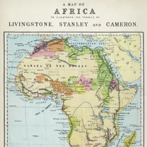
Photographic Print : Ethnographic map of Africa from 1898


![]()
Photo Prints from Fine Art Storehouse
Ethnographic map of Africa from 1898
Illustration of a Ethnographic map of Africa
Unleash your creativity and transform your space into a visual masterpiece!
Nastasic
Media ID 15489841
© This content is subject to copyright
10"x8" (25x20cm) Photo Print
Step back in time with our exquisite Ethnographic Map of Africa from 1898 by Nastasic, now available as a stunning photographic print from Media Storehouse. This captivating piece of historical cartography provides a fascinating insight into the ethnic divisions of Africa as understood during the late 19th century. Meticulously captured and printed in high definition, this fine art print brings the intricacies and details of the map to life, making it a mesmerizing addition to any wall in your home or office. Transport yourself to a bygone era and embark on a journey of discovery with Media Storehouse's Ethnographic Map of Africa from 1898.
Printed on archival quality paper for unrivalled stable artwork permanence and brilliant colour reproduction with accurate colour rendition and smooth tones. Printed on professional 234gsm Fujifilm Crystal Archive DP II paper. 10x8 for landscape images, 8x10 for portrait images.
Our Photo Prints are in a large range of sizes and are printed on Archival Quality Paper for excellent colour reproduction and longevity. They are ideal for framing (our Framed Prints use these) at a reasonable cost. Alternatives include cheaper Poster Prints and higher quality Fine Art Paper, the choice of which is largely dependant on your budget.
Estimated Product Size is 25.4cm x 20.3cm (10" x 8")
These are individually made so all sizes are approximate
Artwork printed orientated as per the preview above, with landscape (horizontal) orientation to match the source image.
FEATURES IN THESE COLLECTIONS
> Fine Art Storehouse
> Map
> Map Illustrations
> Africa
> Related Images
> Maps and Charts
> Related Images
EDITORS COMMENTS
This print showcases an extraordinary piece of history - an ethnographic map of Africa from 1898. Created by the talented artist Nastasic, this illustration offers a fascinating glimpse into the diverse cultures and tribes that inhabited the African continent during that era. The intricate details and vibrant colors used in this artwork bring to life the rich tapestry of African ethnic groups, highlighting their unique traditions, languages, and territories. From the Berbers in North Africa to the Zulu people in Southern Africa, every corner of this vast land is represented with utmost precision. As we gaze upon this remarkable map, we are reminded of how interconnected humanity truly is. It serves as a powerful reminder that despite our differences, we all share a common heritage rooted in our respective cultures and histories. Beyond its aesthetic appeal, this photograph print also holds immense educational value. It allows us to delve deeper into Africa's past and gain a better understanding of its complex social fabric. Whether displayed in classrooms or personal spaces, it sparks curiosity and encourages exploration. Nastasic's artistic prowess shines through every brushstroke on display here. This ethereal image transports us back in time while simultaneously celebrating the enduring beauty and diversity found within one of Earth's most enchanting continents – Africa.
MADE IN THE UK
Safe Shipping with 30 Day Money Back Guarantee
FREE PERSONALISATION*
We are proud to offer a range of customisation features including Personalised Captions, Color Filters and Picture Zoom Tools
SECURE PAYMENTS
We happily accept a wide range of payment options so you can pay for the things you need in the way that is most convenient for you
* Options may vary by product and licensing agreement. Zoomed Pictures can be adjusted in the Basket.